Cuba - Published 1906 by National Geographic
Early 20th Century Political Map | Post-Colonial Turning Point | Panoramic Format (710 × 347 mm) | Premium Finishes
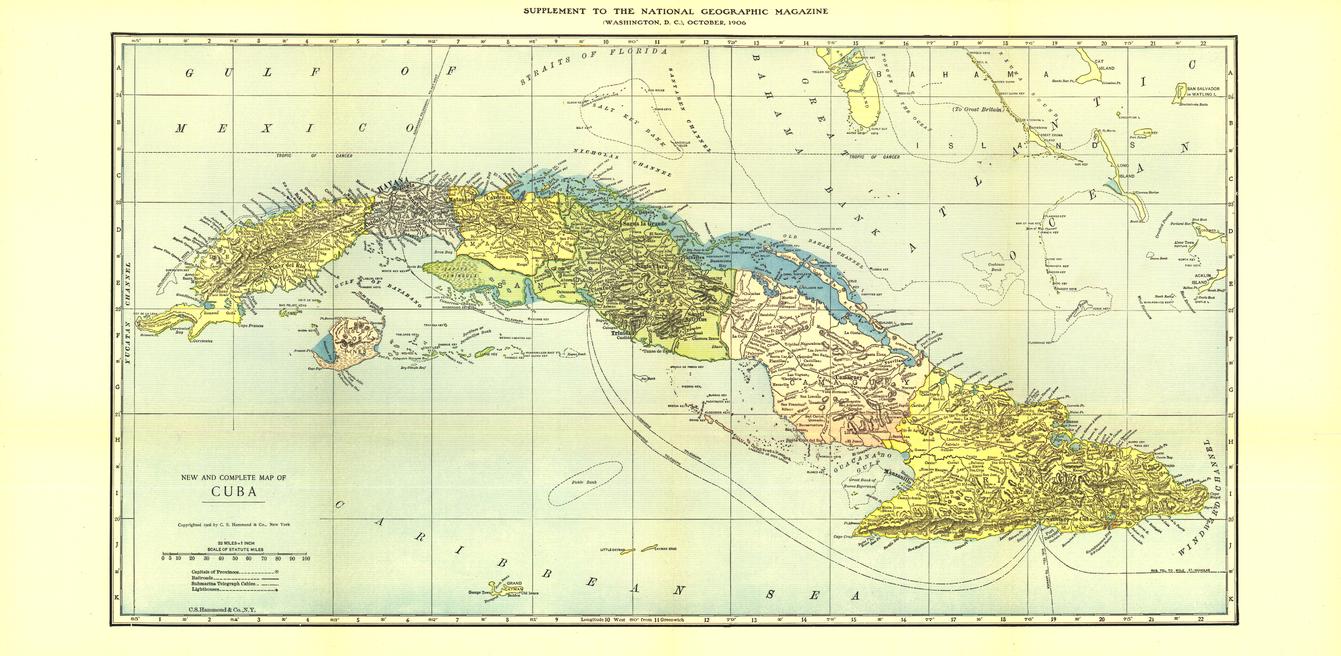
A compelling historical map capturing Cuba at a moment of political upheaval and transformation. Published by National Geographic in October 1906, this piece reflects a pivotal year when disputed elections led to unrest, prompting United States intervention and a temporary occupation of the island.
Rendered in the classic National Geographic style of the early 20th century, this map presents Cuba with clarity and balance—offering both a geographic reference and a window into a defining chapter of its history.
Why This Map Stands Out
A moment frozen in time
Captures Cuba during a key political transition in the early 1900s.
Classic National Geographic cartography
Clean linework, restrained colour, and precise labelling reflect the era’s cartographic standards.
Historical and political significance
Illustrates the island at the time of U.S. intervention and early republic instability.
A collector’s piece
An attractive and authentic historical map ideal for those interested in Caribbean history.
Elegant panoramic format
A wide, low-profile layout that suits a range of display settings.
🗺️ What the Map Shows
- The island of Cuba in full, with surrounding coastal waters
- Major cities and settlements across the island
- Political boundaries and administrative divisions of the period
- Key geographic features including coastlines, rivers, and terrain
- Transport routes and infrastructure as they existed in 1906
- A clear snapshot of Cuba’s geographic and political landscape in the early 20th century
📐 Size & Format
710 mm (W) × 347 mm (H)
Panoramic landscape orientation
A refined, horizontal format ideal for:
- Study walls and offices
- Historical and travel-themed interiors
- Gallery-style arrangements
- Collectors’ displays
✨ Premium Finishes
| Format | Description |
|---|---|
| 📜 Paper (160 gsm) | Heavyweight matte-coated paper—ideal for framing. Preserves the map’s historic tone and fine detail. |
| 🧼 Laminated (Encapsulated) | Sealed in 2 × 80-micron gloss laminate. Durable, wipe-clean, and suitable for regular handling. |
| 🪵 Laminated + Timber Hang Rails | Laminated map mounted with lacquered natural timber rails and hanging cord—ready to display. |
| 🖼️ Canvas (395 gsm HP Professional Matte) | Printed with archival pigment inks. Adds depth and texture to the historic design. |
| 🪵 Canvas + Timber Hang Rails | Canvas paired with timber rails for a refined, gallery-style presentation. |
🔨 Please allow up to 10 working days for professionally mounted hang-railed finishes.
📊 Specifications
| Feature | Detail |
|---|---|
| Title | Cuba — National Geographic Historical Map |
| Publisher | National Geographic |
| Published | 1906 |
| Scale | 1:2,090,880 |
| Dimensions | 710 mm × 347 mm |
| Orientation | Panoramic (Landscape) |
| Map Type | Political / Historical |
| Coverage | Cuba and surrounding Caribbean waters |
| Materials | 160 gsm matte paper / 2 × 80-micron laminate / 395 gsm HP Professional Matte Canvas |
| Printing | Pigment-based, fade-resistant inks |
| Origin | Printed in Australia |
🎯 Ideal For
- Collectors of early National Geographic and historical maps
- Enthusiasts of Caribbean and Cuban history
- Educators exploring post-colonial and geopolitical history
- Interiors styled around heritage, travel, or vintage themes
- Gift buyers seeking a unique and historically significant map
🏝️ An Island at a Turning Point
Cuba in 1906 stood at a crossroads:
- A young republic navigating political instability
- External intervention shaping governance and direction
- A landscape unchanged, yet a nation in transition
- A moment where geography and politics intersected dramatically
This map captures that moment—offering a rare glimpse into a time when the course of the island’s future was still being written.
🤝 Our Commitment
- Printed in Australia using archival-quality production
- Faithfully reproduced to preserve original tone and detail
- Premium materials selected for long-term durability
- Each map is hand-checked before dispatch
- Carefully packaged for safe delivery
🚚 Delivery
- Paper, Laminated, Canvas (rolled): Dispatch within 1–2 business days
- Hang-Railed Maps: Made to order—allow up to 10 working days
- Packaging: Securely rolled in protective tubing
Own a piece of Caribbean history—
a map that captures Cuba at a defining moment in time.
👉 Order now and add this historic map to your collection.
Original: $57.20
-65%$57.20
$20.02Product Information
Product Information
Shipping & Returns
Shipping & Returns
Description
Early 20th Century Political Map | Post-Colonial Turning Point | Panoramic Format (710 × 347 mm) | Premium Finishes
A compelling historical map capturing Cuba at a moment of political upheaval and transformation. Published by National Geographic in October 1906, this piece reflects a pivotal year when disputed elections led to unrest, prompting United States intervention and a temporary occupation of the island.
Rendered in the classic National Geographic style of the early 20th century, this map presents Cuba with clarity and balance—offering both a geographic reference and a window into a defining chapter of its history.
Why This Map Stands Out
A moment frozen in time
Captures Cuba during a key political transition in the early 1900s.
Classic National Geographic cartography
Clean linework, restrained colour, and precise labelling reflect the era’s cartographic standards.
Historical and political significance
Illustrates the island at the time of U.S. intervention and early republic instability.
A collector’s piece
An attractive and authentic historical map ideal for those interested in Caribbean history.
Elegant panoramic format
A wide, low-profile layout that suits a range of display settings.
🗺️ What the Map Shows
- The island of Cuba in full, with surrounding coastal waters
- Major cities and settlements across the island
- Political boundaries and administrative divisions of the period
- Key geographic features including coastlines, rivers, and terrain
- Transport routes and infrastructure as they existed in 1906
- A clear snapshot of Cuba’s geographic and political landscape in the early 20th century
📐 Size & Format
710 mm (W) × 347 mm (H)
Panoramic landscape orientation
A refined, horizontal format ideal for:
- Study walls and offices
- Historical and travel-themed interiors
- Gallery-style arrangements
- Collectors’ displays
✨ Premium Finishes
| Format | Description |
|---|---|
| 📜 Paper (160 gsm) | Heavyweight matte-coated paper—ideal for framing. Preserves the map’s historic tone and fine detail. |
| 🧼 Laminated (Encapsulated) | Sealed in 2 × 80-micron gloss laminate. Durable, wipe-clean, and suitable for regular handling. |
| 🪵 Laminated + Timber Hang Rails | Laminated map mounted with lacquered natural timber rails and hanging cord—ready to display. |
| 🖼️ Canvas (395 gsm HP Professional Matte) | Printed with archival pigment inks. Adds depth and texture to the historic design. |
| 🪵 Canvas + Timber Hang Rails | Canvas paired with timber rails for a refined, gallery-style presentation. |
🔨 Please allow up to 10 working days for professionally mounted hang-railed finishes.
📊 Specifications
| Feature | Detail |
|---|---|
| Title | Cuba — National Geographic Historical Map |
| Publisher | National Geographic |
| Published | 1906 |
| Scale | 1:2,090,880 |
| Dimensions | 710 mm × 347 mm |
| Orientation | Panoramic (Landscape) |
| Map Type | Political / Historical |
| Coverage | Cuba and surrounding Caribbean waters |
| Materials | 160 gsm matte paper / 2 × 80-micron laminate / 395 gsm HP Professional Matte Canvas |
| Printing | Pigment-based, fade-resistant inks |
| Origin | Printed in Australia |
🎯 Ideal For
- Collectors of early National Geographic and historical maps
- Enthusiasts of Caribbean and Cuban history
- Educators exploring post-colonial and geopolitical history
- Interiors styled around heritage, travel, or vintage themes
- Gift buyers seeking a unique and historically significant map
🏝️ An Island at a Turning Point
Cuba in 1906 stood at a crossroads:
- A young republic navigating political instability
- External intervention shaping governance and direction
- A landscape unchanged, yet a nation in transition
- A moment where geography and politics intersected dramatically
This map captures that moment—offering a rare glimpse into a time when the course of the island’s future was still being written.
🤝 Our Commitment
- Printed in Australia using archival-quality production
- Faithfully reproduced to preserve original tone and detail
- Premium materials selected for long-term durability
- Each map is hand-checked before dispatch
- Carefully packaged for safe delivery
🚚 Delivery
- Paper, Laminated, Canvas (rolled): Dispatch within 1–2 business days
- Hang-Railed Maps: Made to order—allow up to 10 working days
- Packaging: Securely rolled in protective tubing
Own a piece of Caribbean history—
a map that captures Cuba at a defining moment in time.
👉 Order now and add this historic map to your collection.


