Deep South - Published 1983 by National Geographic
Historical Regional Map | Culture, Landscape & Heritage | Large Wall Format (687 × 518 mm) | Premium Finishes
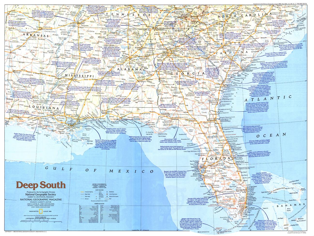
A richly detailed map exploring one of America’s most culturally distinctive regions. Published by National Geographic in August 1983 as part of the Making of America series, Deep South presents a layered view of the region’s geography, history, and cultural identity.
From river systems and coastal plains to historic towns and cultural landmarks, this map offers a compelling snapshot of the Deep South—revealing a landscape shaped by tradition, movement, and enduring heritage.
Why This Map Stands Out
A region rich in history and identity
Captures the Deep South’s unique blend of geography, culture, and historical significance.
Part of the “Making of America” series
Places the region within the broader story of American development and identity.
Classic National Geographic cartography
Clean typography, balanced colour, and precise detail ensure clarity and visual appeal.
A snapshot of 1980s America
Reflects infrastructure, regional connections, and cultural landmarks of the period.
A strong educational and decorative piece
Ideal for both reference and display in a variety of settings.
🗺️ What the Map Shows
- Detailed coverage of the Deep South region of the United States
- Major cities, towns, and transport routes
- River systems, coastal areas, and inland landscapes
- Locations of historic sites, cultural landmarks, and tourist attractions
- Regional features that define the South’s identity
- A geographic framework linking landscape, settlement, and history
📐 Size & Format
687 mm (W) × 518 mm (H)
Landscape orientation
A balanced, wall-friendly format ideal for:
- Home offices and studies
- Classrooms and history displays
- Libraries and research environments
- Interiors inspired by Americana and Southern heritage
✨ Premium Finishes
| Format | Description |
|---|---|
| 📜 Paper (160 gsm) | Heavyweight matte-coated paper—ideal for framing. Preserves crisp detail and subtle colour tones. |
| 🧼 Laminated (Encapsulated) | Sealed in 2 × 80-micron gloss laminate. Durable, wipe-clean, and suitable for frequent reference. |
| 🪵 Laminated + Timber Hang Rails | Laminated map mounted with lacquered natural timber rails and hanging cord—ready to display. |
| 🖼️ Canvas (395 gsm HP Professional Matte) | Printed with archival pigment inks. Rich texture enhances depth and presentation. |
| 🪵 Canvas + Timber Hang Rails | Canvas paired with timber rails for a refined, gallery-style display. |
🔨 Please allow up to 10 working days for professionally mounted hang-railed finishes.
📊 Specifications
| Feature | Detail |
|---|---|
| Title | Deep South |
| Publisher | National Geographic |
| Published | 1983 |
| Scale | 1:2,566,000 |
| Dimensions | 687 mm × 518 mm |
| Orientation | Landscape |
| Map Type | Regional / Historical |
| Series | Making of America |
| Coverage | Deep South, United States |
| Materials | 160 gsm matte paper / 2 × 80-micron laminate / 395 gsm HP Professional Matte Canvas |
| Printing | Pigment-based, fade-resistant inks |
| Origin | Printed in Australia |
🎯 Ideal For
- Collectors of National Geographic and historical maps
- Enthusiasts of Southern U.S. history and culture
- Educators teaching regional geography and heritage
- Interiors seeking a classic Americana aesthetic
- Gift buyers looking for a meaningful and region-specific map
🌾 A Region Shaped by Land and Legacy
The Deep South is a place of depth and continuity:
- River systems guiding settlement and commerce
- Landscapes tied to agriculture and tradition
- Towns and cities reflecting layered histories
- A cultural identity shaped by place, people, and time
This map captures that complexity—revealing a region where geography and heritage remain deeply connected.
🤝 Our Commitment
- Printed in Australia using archival-quality production
- Faithfully reproduced to preserve clarity and original detail
- Premium materials selected for durability and long-term display
- Each map is hand-checked before dispatch
- Carefully packaged for safe delivery
🚚 Delivery
- Paper, Laminated, Canvas (rolled): Dispatch within 1–2 business days
- Hang-Railed Maps: Made to order—allow up to 10 working days
- Packaging: Securely rolled in protective tubing
Explore the landscapes and legacy of the Deep South—
a map that brings history, culture, and geography together.
👉 Order now and own a classic piece of National Geographic cartography.
Original: $57.20
-65%$57.20
$20.02Product Information
Product Information
Shipping & Returns
Shipping & Returns
Description
Historical Regional Map | Culture, Landscape & Heritage | Large Wall Format (687 × 518 mm) | Premium Finishes
A richly detailed map exploring one of America’s most culturally distinctive regions. Published by National Geographic in August 1983 as part of the Making of America series, Deep South presents a layered view of the region’s geography, history, and cultural identity.
From river systems and coastal plains to historic towns and cultural landmarks, this map offers a compelling snapshot of the Deep South—revealing a landscape shaped by tradition, movement, and enduring heritage.
Why This Map Stands Out
A region rich in history and identity
Captures the Deep South’s unique blend of geography, culture, and historical significance.
Part of the “Making of America” series
Places the region within the broader story of American development and identity.
Classic National Geographic cartography
Clean typography, balanced colour, and precise detail ensure clarity and visual appeal.
A snapshot of 1980s America
Reflects infrastructure, regional connections, and cultural landmarks of the period.
A strong educational and decorative piece
Ideal for both reference and display in a variety of settings.
🗺️ What the Map Shows
- Detailed coverage of the Deep South region of the United States
- Major cities, towns, and transport routes
- River systems, coastal areas, and inland landscapes
- Locations of historic sites, cultural landmarks, and tourist attractions
- Regional features that define the South’s identity
- A geographic framework linking landscape, settlement, and history
📐 Size & Format
687 mm (W) × 518 mm (H)
Landscape orientation
A balanced, wall-friendly format ideal for:
- Home offices and studies
- Classrooms and history displays
- Libraries and research environments
- Interiors inspired by Americana and Southern heritage
✨ Premium Finishes
| Format | Description |
|---|---|
| 📜 Paper (160 gsm) | Heavyweight matte-coated paper—ideal for framing. Preserves crisp detail and subtle colour tones. |
| 🧼 Laminated (Encapsulated) | Sealed in 2 × 80-micron gloss laminate. Durable, wipe-clean, and suitable for frequent reference. |
| 🪵 Laminated + Timber Hang Rails | Laminated map mounted with lacquered natural timber rails and hanging cord—ready to display. |
| 🖼️ Canvas (395 gsm HP Professional Matte) | Printed with archival pigment inks. Rich texture enhances depth and presentation. |
| 🪵 Canvas + Timber Hang Rails | Canvas paired with timber rails for a refined, gallery-style display. |
🔨 Please allow up to 10 working days for professionally mounted hang-railed finishes.
📊 Specifications
| Feature | Detail |
|---|---|
| Title | Deep South |
| Publisher | National Geographic |
| Published | 1983 |
| Scale | 1:2,566,000 |
| Dimensions | 687 mm × 518 mm |
| Orientation | Landscape |
| Map Type | Regional / Historical |
| Series | Making of America |
| Coverage | Deep South, United States |
| Materials | 160 gsm matte paper / 2 × 80-micron laminate / 395 gsm HP Professional Matte Canvas |
| Printing | Pigment-based, fade-resistant inks |
| Origin | Printed in Australia |
🎯 Ideal For
- Collectors of National Geographic and historical maps
- Enthusiasts of Southern U.S. history and culture
- Educators teaching regional geography and heritage
- Interiors seeking a classic Americana aesthetic
- Gift buyers looking for a meaningful and region-specific map
🌾 A Region Shaped by Land and Legacy
The Deep South is a place of depth and continuity:
- River systems guiding settlement and commerce
- Landscapes tied to agriculture and tradition
- Towns and cities reflecting layered histories
- A cultural identity shaped by place, people, and time
This map captures that complexity—revealing a region where geography and heritage remain deeply connected.
🤝 Our Commitment
- Printed in Australia using archival-quality production
- Faithfully reproduced to preserve clarity and original detail
- Premium materials selected for durability and long-term display
- Each map is hand-checked before dispatch
- Carefully packaged for safe delivery
🚚 Delivery
- Paper, Laminated, Canvas (rolled): Dispatch within 1–2 business days
- Hang-Railed Maps: Made to order—allow up to 10 working days
- Packaging: Securely rolled in protective tubing
Explore the landscapes and legacy of the Deep South—
a map that brings history, culture, and geography together.
👉 Order now and own a classic piece of National Geographic cartography.


