Earths Dynamic Crust - Published 1985 by National Geographic
Global Tectonics Map | Plates, Volcanoes & Earthquakes | Wall Format (575 × 454 mm) | Premium Finishes
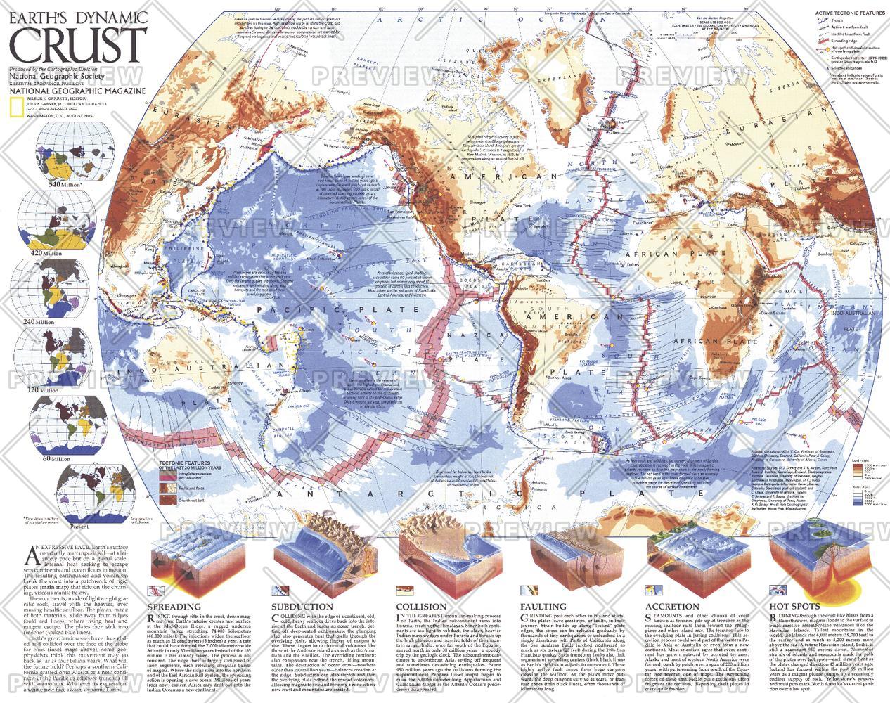
A clear and compelling look at the forces shaping our planet, Earth’s Dynamic Crust reveals the restless mechanics beneath Earth’s surface. Published by National Geographic in August 1985, this map was created as part of a two-piece set alongside The Shaping of a Continent: North America’s Active West and the article “Our Restless Planet Earth.”
Combining scientific explanation with global mapping, it illustrates how tectonic processes—often invisible to us—continually reshape continents, oceans, and landscapes.
Why This Map Stands Out
A global view of tectonic activity
Shows how Earth’s crust is constantly moving, colliding, and evolving.
Explains key geological processes
Breaks down complex concepts like subduction and spreading into clear visual form.
Data-driven and time-specific
Includes earthquake activity (magnitude 6.0+) recorded between 1975–1985.
National Geographic clarity
Combines scientific depth with accessible, well-balanced cartography.
An essential educational piece
Ideal for understanding the mechanics behind earthquakes, volcanoes, and continental movement.
🗺️ What the Map Shows
- Global distribution of tectonic plate boundaries
- Key geological processes including:
- Subduction zones
- Seafloor spreading
- Accretion
- Hot spots
- Locations of major volcanoes worldwide
- Earthquakes of magnitude 6.0 and greater (1975–1985)
- The relationship between tectonic movement and surface features
- A visual explanation of how Earth’s crust is shaped over time
📐 Size & Format
575 mm (W) × 454 mm (H)
Landscape orientation
A compact, information-rich format ideal for:
- Classrooms and science labs
- Home offices and study spaces
- Libraries and educational displays
- Interiors focused on science and natural processes
✨ Premium Finishes
| Format | Description |
|---|---|
| 📜 Paper (160 gsm) | Heavyweight matte-coated paper—ideal for framing. Preserves clarity and fine detail. |
| 🧼 Laminated (Encapsulated) | Sealed in 2 × 80-micron gloss laminate. Durable, wipe-clean, and ideal for frequent reference. |
| 🪵 Laminated + Timber Hang Rails | Laminated map mounted with lacquered natural timber rails and hanging cord—ready to display. |
| 🖼️ Canvas (395 gsm HP Professional Matte) | Printed with archival pigment inks. Rich texture enhances visual depth and presentation. |
| 🪵 Canvas + Timber Hang Rails | Canvas paired with timber rails for a refined, gallery-style display. |
🔨 Please allow up to 10 working days for professionally mounted hang-railed finishes.
📊 Specifications
| Feature | Detail |
|---|---|
| Title | Earth’s Dynamic Crust |
| Publisher | National Geographic |
| Published | 1985 |
| Dimensions | 575 mm × 454 mm |
| Orientation | Landscape |
| Map Type | Thematic / Scientific |
| Focus | Tectonic plates, earthquakes, volcanoes |
| Collections | World, Historical |
| Materials | 160 gsm matte paper / 2 × 80-micron laminate / 395 gsm HP Professional Matte Canvas |
| Printing | Pigment-based, fade-resistant inks |
| Origin | Printed in Australia |
🎯 Ideal For
- Students and educators of geology and earth science
- Enthusiasts of tectonics, volcanoes, and earthquakes
- Classrooms needing a clear visual teaching aid
- Offices and study spaces focused on science and global systems
- Gift buyers seeking a thoughtful and educational map
🌍 A Planet in Motion
Beneath our feet, the Earth is constantly changing:
- Plates drifting, colliding, and reshaping continents
- Volcanoes marking the release of internal energy
- Earthquakes signalling movement along hidden boundaries
- A dynamic system driving the evolution of our planet
This map brings those forces into view—revealing a world that is not static, but alive with movement and change.
🤝 Our Commitment
- Printed in Australia using archival-quality production
- Faithfully reproduced to preserve clarity and scientific detail
- Premium materials selected for durability and long-term use
- Each map is hand-checked before dispatch
- Carefully packaged for safe delivery
🚚 Delivery
- Paper, Laminated, Canvas (rolled): Dispatch within 1–2 business days
- Hang-Railed Maps: Made to order—allow up to 10 working days
- Packaging: Securely rolled in protective tubing
Understand the forces that shape our world—
a map that reveals the dynamic nature of the Earth beneath us.
👉 Order now and bring Earth science into sharp focus.
Original: $57.20
-65%$57.20
$20.02Product Information
Product Information
Shipping & Returns
Shipping & Returns
Description
Global Tectonics Map | Plates, Volcanoes & Earthquakes | Wall Format (575 × 454 mm) | Premium Finishes
A clear and compelling look at the forces shaping our planet, Earth’s Dynamic Crust reveals the restless mechanics beneath Earth’s surface. Published by National Geographic in August 1985, this map was created as part of a two-piece set alongside The Shaping of a Continent: North America’s Active West and the article “Our Restless Planet Earth.”
Combining scientific explanation with global mapping, it illustrates how tectonic processes—often invisible to us—continually reshape continents, oceans, and landscapes.
Why This Map Stands Out
A global view of tectonic activity
Shows how Earth’s crust is constantly moving, colliding, and evolving.
Explains key geological processes
Breaks down complex concepts like subduction and spreading into clear visual form.
Data-driven and time-specific
Includes earthquake activity (magnitude 6.0+) recorded between 1975–1985.
National Geographic clarity
Combines scientific depth with accessible, well-balanced cartography.
An essential educational piece
Ideal for understanding the mechanics behind earthquakes, volcanoes, and continental movement.
🗺️ What the Map Shows
- Global distribution of tectonic plate boundaries
- Key geological processes including:
- Subduction zones
- Seafloor spreading
- Accretion
- Hot spots
- Locations of major volcanoes worldwide
- Earthquakes of magnitude 6.0 and greater (1975–1985)
- The relationship between tectonic movement and surface features
- A visual explanation of how Earth’s crust is shaped over time
📐 Size & Format
575 mm (W) × 454 mm (H)
Landscape orientation
A compact, information-rich format ideal for:
- Classrooms and science labs
- Home offices and study spaces
- Libraries and educational displays
- Interiors focused on science and natural processes
✨ Premium Finishes
| Format | Description |
|---|---|
| 📜 Paper (160 gsm) | Heavyweight matte-coated paper—ideal for framing. Preserves clarity and fine detail. |
| 🧼 Laminated (Encapsulated) | Sealed in 2 × 80-micron gloss laminate. Durable, wipe-clean, and ideal for frequent reference. |
| 🪵 Laminated + Timber Hang Rails | Laminated map mounted with lacquered natural timber rails and hanging cord—ready to display. |
| 🖼️ Canvas (395 gsm HP Professional Matte) | Printed with archival pigment inks. Rich texture enhances visual depth and presentation. |
| 🪵 Canvas + Timber Hang Rails | Canvas paired with timber rails for a refined, gallery-style display. |
🔨 Please allow up to 10 working days for professionally mounted hang-railed finishes.
📊 Specifications
| Feature | Detail |
|---|---|
| Title | Earth’s Dynamic Crust |
| Publisher | National Geographic |
| Published | 1985 |
| Dimensions | 575 mm × 454 mm |
| Orientation | Landscape |
| Map Type | Thematic / Scientific |
| Focus | Tectonic plates, earthquakes, volcanoes |
| Collections | World, Historical |
| Materials | 160 gsm matte paper / 2 × 80-micron laminate / 395 gsm HP Professional Matte Canvas |
| Printing | Pigment-based, fade-resistant inks |
| Origin | Printed in Australia |
🎯 Ideal For
- Students and educators of geology and earth science
- Enthusiasts of tectonics, volcanoes, and earthquakes
- Classrooms needing a clear visual teaching aid
- Offices and study spaces focused on science and global systems
- Gift buyers seeking a thoughtful and educational map
🌍 A Planet in Motion
Beneath our feet, the Earth is constantly changing:
- Plates drifting, colliding, and reshaping continents
- Volcanoes marking the release of internal energy
- Earthquakes signalling movement along hidden boundaries
- A dynamic system driving the evolution of our planet
This map brings those forces into view—revealing a world that is not static, but alive with movement and change.
🤝 Our Commitment
- Printed in Australia using archival-quality production
- Faithfully reproduced to preserve clarity and scientific detail
- Premium materials selected for durability and long-term use
- Each map is hand-checked before dispatch
- Carefully packaged for safe delivery
🚚 Delivery
- Paper, Laminated, Canvas (rolled): Dispatch within 1–2 business days
- Hang-Railed Maps: Made to order—allow up to 10 working days
- Packaging: Securely rolled in protective tubing
Understand the forces that shape our world—
a map that reveals the dynamic nature of the Earth beneath us.
👉 Order now and bring Earth science into sharp focus.


