Eastern Mediterranean Atlas of the World, 11th Edition, National Geographic Wall Map
From National Geographic’s 11th Edition Atlas of the World
A breathtaking cartographic celebration of one of history’s most culturally rich and geopolitically important regions.
🌍 Explore the Crossroads of Civilisations
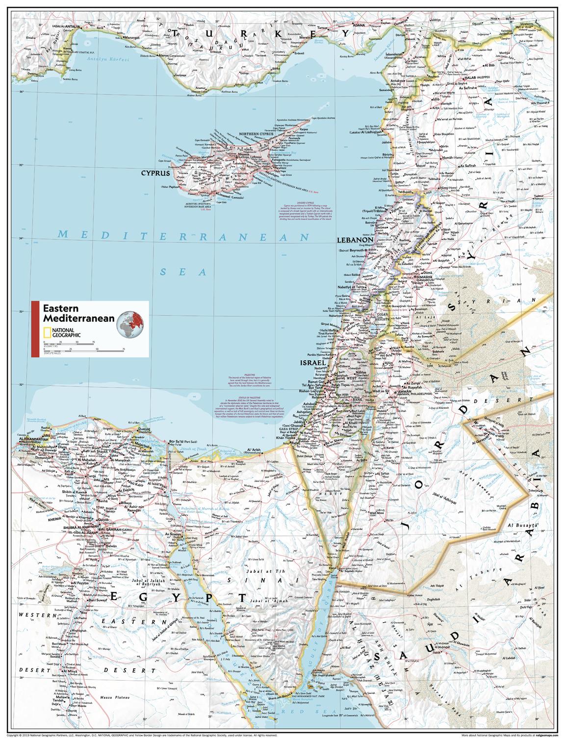
Step into the heart of the ancient world with the Eastern Mediterranean Wall Map, a detailed and beautifully crafted cartographic work from National Geographic. Capturing the sun-drenched coastlines, rugged mountains, and vibrant cities of this pivotal region, the map is both a powerful geographic reference and a striking wall feature.
This meticulously rendered map covers a diverse region that bridges Europe, Asia, and Africa — encompassing parts of Greece, Turkey, Cyprus, the Levant, and the eastern shores of the Mediterranean Sea. Whether you’re studying ancient trade routes, planning a journey, or enriching a classroom, this map brings the region to life with clarity and elegance.
🧭 Key Features
-
🗺️ Up-to-date political boundaries and major cities, ports, and capitals
-
🌊 Physical terrain shaded relief to illustrate mountains, rivers, deserts, and coastline contours
-
🎓 Ideal for education — perfect for teaching regional geography, history, and environmental studies
-
✍️ Crisp, clear typography ensures all place names are legible and beautifully balanced
-
🎨 Classic National Geographic colour palette with bright oceans and natural earth tones
🖼️ Premium Format Options
| 📌 Version | Description |
|---|---|
| 📄 Paper (160gsm Matte Coated) | Printed on premium matte-coated 160gsm paper — ideal for framing under glass. |
| 💧 Laminated (Gloss) | Encapsulated with 80-micron gloss laminate — durable, wipe-clean, and vibrant. |
| 🖼️ Canvas (395gsm) | Printed on HP Professional Matte Canvas with pigment inks — fade-resistant, archival quality. |
| 🪵 Laminated + Timber Rails | Gloss laminated map with natural timber hang rails and hanging cord — ready to display. |
| 🪵 Canvas + Timber Rails | Canvas map with timber hangers — tactile, gallery-style wall presentation. |
⏳ Please allow 10 working days for delivery of hang-railed versions as they are custom-finished by our local framer.
📐 Map Specifications
| Attribute | Details |
|---|---|
| Title | Eastern Mediterranean – Political & Physical Wall Map |
| Publisher | National Geographic |
| Edition | 11th Edition Atlas of the World |
| Available Sizes | STANDARD – 610 mm (W) × 790 mm (H) SUPERMAP – 915 mm (W) × 1197 mm (H) |
| Publication Year | 2019 |
| Made In | Australia |
✨ Why Choose This Map?
✔️ Authoritative cartography from one of the world’s most trusted mapmakers
✔️ A unique blend of aesthetics and information — both beautiful and useful
✔️ Perfect for homes, classrooms, libraries, and offices
✔️ Custom presentation options for every display setting
✔️ A meaningful gift for history buffs, educators, and travellers
🎁 A Journey Begins with the Right Map
From the islands of the Aegean to the shores of the Levant, the Eastern Mediterranean is a tapestry of cultures, histories, and natural beauty. Let this map be your window to a region that has shaped the course of civilisation for millennia.
Original: $50.05
-65%$50.05
$17.52Product Information
Product Information
Shipping & Returns
Shipping & Returns
Description
From National Geographic’s 11th Edition Atlas of the World
A breathtaking cartographic celebration of one of history’s most culturally rich and geopolitically important regions.
🌍 Explore the Crossroads of Civilisations
Step into the heart of the ancient world with the Eastern Mediterranean Wall Map, a detailed and beautifully crafted cartographic work from National Geographic. Capturing the sun-drenched coastlines, rugged mountains, and vibrant cities of this pivotal region, the map is both a powerful geographic reference and a striking wall feature.
This meticulously rendered map covers a diverse region that bridges Europe, Asia, and Africa — encompassing parts of Greece, Turkey, Cyprus, the Levant, and the eastern shores of the Mediterranean Sea. Whether you’re studying ancient trade routes, planning a journey, or enriching a classroom, this map brings the region to life with clarity and elegance.
🧭 Key Features
-
🗺️ Up-to-date political boundaries and major cities, ports, and capitals
-
🌊 Physical terrain shaded relief to illustrate mountains, rivers, deserts, and coastline contours
-
🎓 Ideal for education — perfect for teaching regional geography, history, and environmental studies
-
✍️ Crisp, clear typography ensures all place names are legible and beautifully balanced
-
🎨 Classic National Geographic colour palette with bright oceans and natural earth tones
🖼️ Premium Format Options
| 📌 Version | Description |
|---|---|
| 📄 Paper (160gsm Matte Coated) | Printed on premium matte-coated 160gsm paper — ideal for framing under glass. |
| 💧 Laminated (Gloss) | Encapsulated with 80-micron gloss laminate — durable, wipe-clean, and vibrant. |
| 🖼️ Canvas (395gsm) | Printed on HP Professional Matte Canvas with pigment inks — fade-resistant, archival quality. |
| 🪵 Laminated + Timber Rails | Gloss laminated map with natural timber hang rails and hanging cord — ready to display. |
| 🪵 Canvas + Timber Rails | Canvas map with timber hangers — tactile, gallery-style wall presentation. |
⏳ Please allow 10 working days for delivery of hang-railed versions as they are custom-finished by our local framer.
📐 Map Specifications
| Attribute | Details |
|---|---|
| Title | Eastern Mediterranean – Political & Physical Wall Map |
| Publisher | National Geographic |
| Edition | 11th Edition Atlas of the World |
| Available Sizes | STANDARD – 610 mm (W) × 790 mm (H) SUPERMAP – 915 mm (W) × 1197 mm (H) |
| Publication Year | 2019 |
| Made In | Australia |
✨ Why Choose This Map?
✔️ Authoritative cartography from one of the world’s most trusted mapmakers
✔️ A unique blend of aesthetics and information — both beautiful and useful
✔️ Perfect for homes, classrooms, libraries, and offices
✔️ Custom presentation options for every display setting
✔️ A meaningful gift for history buffs, educators, and travellers
🎁 A Journey Begins with the Right Map
From the islands of the Aegean to the shores of the Levant, the Eastern Mediterranean is a tapestry of cultures, histories, and natural beauty. Let this map be your window to a region that has shaped the course of civilisation for millennia.


