Economy: Straining Financial Links - Atlas of the World, 10th Edition by National Geographic
Economy: Straining Financial Links - Atlas of the World, 10th Edition by National Geographic
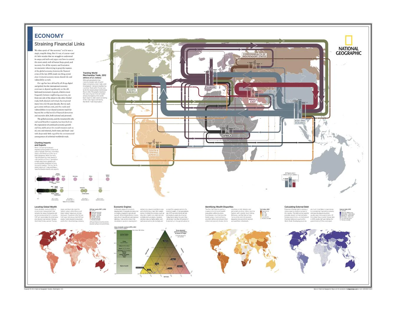
World Thematic Map | Global Trade, Wealth & Debt | Atlas of the World, 10th Edition (711 × 559 mm) | Premium Finishes
A sophisticated snapshot of the global economy in motion, Economy: Straining Financial Links examines how goods, capital, and wealth move across the world—and where pressures are building. Published by National Geographic as part of the Atlas of the World, 10th Edition (Plate 24), this map presents a clear, data-driven view of international trade, economic power, and financial imbalance.
From trade flows to debt burdens, it transforms complex economic relationships into a compelling visual narrative—revealing a world that is deeply interconnected, yet unevenly balanced.
Why This Map Stands Out
A global economic snapshot
Captures the structure of world trade and financial relationships at a key moment in time.
Data-rich and visually clear
Transforms complex economic indicators into accessible, easy-to-read mapping.
Atlas-level authority
Drawn from National Geographic’s flagship atlas series—trusted, precise, and highly regarded.
Highlights inequality and imbalance
Reveals contrasts in wealth distribution, economic output, and external debt.
A meaningful and contemporary wall piece
Ideal for those interested in global economics, geopolitics, and international trade.
🗺️ What the Map Shows
- Global patterns of merchandise trade (circa 2012)
- Major import and export flows between countries and regions
- Distribution of global wealth and economic output
- Key economic engines and high-growth regions
- Geographic patterns of wealth disparity and inequality
- National and regional levels of external debt
- The interconnected nature of the global financial system
📐 Size & Format
711 mm (W) × 559 mm (H)
Landscape orientation
A balanced format ideal for:
- Offices and boardrooms
- Classrooms and university settings
- Home studies and workspaces
- Interiors focused on global awareness and strategy
✨ Premium Finishes
| Format | Description |
|---|---|
| 📜 Paper (160 gsm) | Heavyweight matte-coated paper—ideal for framing. Preserves clarity and fine detail. |
| 🧼 Laminated (Encapsulated) | Sealed in 2 × 80-micron gloss laminate. Durable, wipe-clean, and suitable for frequent reference. |
| 🪵 Laminated + Timber Hang Rails | Laminated map mounted with lacquered natural timber rails and hanging cord—ready to display. |
| 🖼️ Canvas (395 gsm HP Professional Matte) | Printed with archival pigment inks. Rich texture enhances depth and presentation. |
| 🪵 Canvas + Timber Hang Rails | Canvas paired with timber rails for a refined, gallery-style display. |
🔨 Please allow up to 10 working days for professionally mounted hang-railed finishes.
📊 Specifications
| Feature | Detail |
|---|---|
| Title | Economy: Straining Financial Links |
| Publisher | National Geographic |
| Published | 25 February 2015 |
| Source | Atlas of the World, 10th Edition (Plate 24) |
| Dimensions | 711 mm × 559 mm |
| Orientation | Landscape |
| Map Type | Thematic / Economic |
| Focus | Trade, wealth distribution, imports/exports, external debt |
| Materials | 160 gsm matte paper / 2 × 80-micron laminate / 395 gsm HP Professional Matte Canvas |
| Printing | Pigment-based, fade-resistant inks |
| Origin | Printed in Australia |
🎯 Ideal For
- Students and educators of economics, geography, and global studies
- Professionals in finance, trade, and international business
- Offices and boardrooms needing a clear global economic overview
- Researchers exploring wealth distribution and economic systems
- Gift buyers seeking a thoughtful and intellectually engaging map
🌍 A World Connected by Trade—and Tension
The global economy is a network of relationships:
- Goods flowing across borders in complex supply chains
- Wealth concentrated in some regions while others strive to grow
- Nations linked through debt, trade, and financial dependency
- Economic engines driving growth—and pressures building beneath them
This map captures that dynamic—revealing a system that is both interconnected and under strain.
🤝 Our Commitment
- Printed in Australia using archival-quality production
- Faithfully reproduced to preserve clarity and data accuracy
- Premium materials selected for durability and long-term display
- Each map is hand-checked before dispatch
- Carefully packaged for safe delivery
🚚 Delivery
- Paper, Laminated, Canvas (rolled): Dispatch within 1–2 business days
- Hang-Railed Maps: Made to order—allow up to 10 working days
- Packaging: Securely rolled in protective tubing
Understand the forces shaping the global economy—
a map that brings trade, wealth, and financial systems into sharp focus.
👉 Order now and add a powerful economic perspective to your wall.
Product Information
Product Information
Shipping & Returns
Shipping & Returns
Description
World Thematic Map | Global Trade, Wealth & Debt | Atlas of the World, 10th Edition (711 × 559 mm) | Premium Finishes
A sophisticated snapshot of the global economy in motion, Economy: Straining Financial Links examines how goods, capital, and wealth move across the world—and where pressures are building. Published by National Geographic as part of the Atlas of the World, 10th Edition (Plate 24), this map presents a clear, data-driven view of international trade, economic power, and financial imbalance.
From trade flows to debt burdens, it transforms complex economic relationships into a compelling visual narrative—revealing a world that is deeply interconnected, yet unevenly balanced.
Why This Map Stands Out
A global economic snapshot
Captures the structure of world trade and financial relationships at a key moment in time.
Data-rich and visually clear
Transforms complex economic indicators into accessible, easy-to-read mapping.
Atlas-level authority
Drawn from National Geographic’s flagship atlas series—trusted, precise, and highly regarded.
Highlights inequality and imbalance
Reveals contrasts in wealth distribution, economic output, and external debt.
A meaningful and contemporary wall piece
Ideal for those interested in global economics, geopolitics, and international trade.
🗺️ What the Map Shows
- Global patterns of merchandise trade (circa 2012)
- Major import and export flows between countries and regions
- Distribution of global wealth and economic output
- Key economic engines and high-growth regions
- Geographic patterns of wealth disparity and inequality
- National and regional levels of external debt
- The interconnected nature of the global financial system
📐 Size & Format
711 mm (W) × 559 mm (H)
Landscape orientation
A balanced format ideal for:
- Offices and boardrooms
- Classrooms and university settings
- Home studies and workspaces
- Interiors focused on global awareness and strategy
✨ Premium Finishes
| Format | Description |
|---|---|
| 📜 Paper (160 gsm) | Heavyweight matte-coated paper—ideal for framing. Preserves clarity and fine detail. |
| 🧼 Laminated (Encapsulated) | Sealed in 2 × 80-micron gloss laminate. Durable, wipe-clean, and suitable for frequent reference. |
| 🪵 Laminated + Timber Hang Rails | Laminated map mounted with lacquered natural timber rails and hanging cord—ready to display. |
| 🖼️ Canvas (395 gsm HP Professional Matte) | Printed with archival pigment inks. Rich texture enhances depth and presentation. |
| 🪵 Canvas + Timber Hang Rails | Canvas paired with timber rails for a refined, gallery-style display. |
🔨 Please allow up to 10 working days for professionally mounted hang-railed finishes.
📊 Specifications
| Feature | Detail |
|---|---|
| Title | Economy: Straining Financial Links |
| Publisher | National Geographic |
| Published | 25 February 2015 |
| Source | Atlas of the World, 10th Edition (Plate 24) |
| Dimensions | 711 mm × 559 mm |
| Orientation | Landscape |
| Map Type | Thematic / Economic |
| Focus | Trade, wealth distribution, imports/exports, external debt |
| Materials | 160 gsm matte paper / 2 × 80-micron laminate / 395 gsm HP Professional Matte Canvas |
| Printing | Pigment-based, fade-resistant inks |
| Origin | Printed in Australia |
🎯 Ideal For
- Students and educators of economics, geography, and global studies
- Professionals in finance, trade, and international business
- Offices and boardrooms needing a clear global economic overview
- Researchers exploring wealth distribution and economic systems
- Gift buyers seeking a thoughtful and intellectually engaging map
🌍 A World Connected by Trade—and Tension
The global economy is a network of relationships:
- Goods flowing across borders in complex supply chains
- Wealth concentrated in some regions while others strive to grow
- Nations linked through debt, trade, and financial dependency
- Economic engines driving growth—and pressures building beneath them
This map captures that dynamic—revealing a system that is both interconnected and under strain.
🤝 Our Commitment
- Printed in Australia using archival-quality production
- Faithfully reproduced to preserve clarity and data accuracy
- Premium materials selected for durability and long-term display
- Each map is hand-checked before dispatch
- Carefully packaged for safe delivery
🚚 Delivery
- Paper, Laminated, Canvas (rolled): Dispatch within 1–2 business days
- Hang-Railed Maps: Made to order—allow up to 10 working days
- Packaging: Securely rolled in protective tubing
Understand the forces shaping the global economy—
a map that brings trade, wealth, and financial systems into sharp focus.
👉 Order now and add a powerful economic perspective to your wall.


