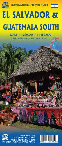
El Salvador & Southern Guatemala ITMB Map
🇸🇻🇬🇹 El Salvador & Southern Guatemala Map – ITMB
Double-Sided | Historical Sites Highlighted | Optional Lamination
Scale: 1:250,000
Flat Size: 690 mm x 1000 mm (27" x 39")
Material: Folded paper map (lamination optional)
Explore two culturally rich and geographically diverse nations with this double-sided map of El Salvador and Southern Guatemala from ITMB (International Travel Maps). Designed for both travellers and educational users, this detailed map brings together colonial history, volcanic landscapes, and Mayan heritage across two neighbouring countries in a single sheet.
Whether you're planning a trip through Central America or studying the region’s layered history, this combination map offers clarity, accuracy, and cultural depth in a durable and practical format.
🗺️ Map Coverage
Side 1: 🇸🇻 El Salvador
-
Full country coverage at 1:250,000 scale
-
Highlights include:
-
🗺️ Inset map of San Salvador, the capital
-
🏛️ Colonial towns such as Suchitoto, Santa Ana, Santa Tecla, and La Palma
-
🌋 Izalco Volcano, one of the world’s youngest and still active
-
🌿 El Imposible National Park
-
🏺 Chalchuapa – a World Heritage site with over 3,000 years of history
-
Side 2: 🇬🇹 Southern Guatemala
-
Covers the southern central region of Guatemala
-
Key locations:
-
🏙️ Quetzaltenango – site of the 1524 Spanish conquest
-
🏛️ Antigua Guatemala – colonial city founded in 1690
-
🏺 Quiriguá – Mayan ruins dating from 200 AD
-
-
🚧 Border crossings with El Salvador clearly marked
🌟 Key Features
-
🗺️ Double-sided format: two maps in one, ideal for regional travel
-
🧭 Clear depiction of highways, secondary roads, borders, and towns
-
📍 Tourist destinations, historical landmarks, and national parks highlighted
-
🏛️ Emphasis on archaeological and cultural heritage
-
🛂 Border crossings shown with ease-of-access indicators
-
🧾 Place name index and regional labelling for quick reference
💧 Lamination Option Available
Upgrade to a laminated version for added durability:
-
✔️ Use whiteboard markers or map dots without damaging the surface
-
✔️ Protects against spills, tears, and general wear
-
✔️ Perfect for repeated use in classrooms, travel planning, or tour offices
📌 Note: Laminated versions are produced by flattening and encapsulating the folded map. Some minor fold lines may remain visible.
🧾 Map Specifications
| Feature | Details |
|---|---|
| Publisher | ITMB (International Travel Maps) |
| Edition | Latest available |
| Map Type | Double-sided folded map |
| Scale | 1:250,000 |
| Material | Paper (laminated version optional) |
| Flat Size | 690 mm x 1000 mm (27" x 39") |
| Language | English |
🧳 Who Is This Map For?
Ideal for:
-
✈️ Travellers exploring Central America by road or backpack
-
🗺️ Students and educators focusing on Mesoamerican geography or history
-
🧭 Heritage and archaeology enthusiasts seeking colonial towns and Mayan sites
-
🧳 Tour guides and travel planners offering regional itineraries
-
🌋 Nature lovers and hikers visiting volcanoes and national parks
🌍 Why Choose This Map?
This map is a rare and practical resource that covers two fascinating countries on one sheet. It’s packed with cultural context, road networks, and natural highlights, making it a perfect companion for deeper, off-the-beaten-path travel. Whether you’re retracing Spanish colonial routes or heading to ancient Mayan cities, this map gives you the regional overview and local detail you need.
Product Information
Product Information
Shipping & Returns
Shipping & Returns
Description
🇸🇻🇬🇹 El Salvador & Southern Guatemala Map – ITMB
Double-Sided | Historical Sites Highlighted | Optional Lamination
Scale: 1:250,000
Flat Size: 690 mm x 1000 mm (27" x 39")
Material: Folded paper map (lamination optional)
Explore two culturally rich and geographically diverse nations with this double-sided map of El Salvador and Southern Guatemala from ITMB (International Travel Maps). Designed for both travellers and educational users, this detailed map brings together colonial history, volcanic landscapes, and Mayan heritage across two neighbouring countries in a single sheet.
Whether you're planning a trip through Central America or studying the region’s layered history, this combination map offers clarity, accuracy, and cultural depth in a durable and practical format.
🗺️ Map Coverage
Side 1: 🇸🇻 El Salvador
-
Full country coverage at 1:250,000 scale
-
Highlights include:
-
🗺️ Inset map of San Salvador, the capital
-
🏛️ Colonial towns such as Suchitoto, Santa Ana, Santa Tecla, and La Palma
-
🌋 Izalco Volcano, one of the world’s youngest and still active
-
🌿 El Imposible National Park
-
🏺 Chalchuapa – a World Heritage site with over 3,000 years of history
-
Side 2: 🇬🇹 Southern Guatemala
-
Covers the southern central region of Guatemala
-
Key locations:
-
🏙️ Quetzaltenango – site of the 1524 Spanish conquest
-
🏛️ Antigua Guatemala – colonial city founded in 1690
-
🏺 Quiriguá – Mayan ruins dating from 200 AD
-
-
🚧 Border crossings with El Salvador clearly marked
🌟 Key Features
-
🗺️ Double-sided format: two maps in one, ideal for regional travel
-
🧭 Clear depiction of highways, secondary roads, borders, and towns
-
📍 Tourist destinations, historical landmarks, and national parks highlighted
-
🏛️ Emphasis on archaeological and cultural heritage
-
🛂 Border crossings shown with ease-of-access indicators
-
🧾 Place name index and regional labelling for quick reference
💧 Lamination Option Available
Upgrade to a laminated version for added durability:
-
✔️ Use whiteboard markers or map dots without damaging the surface
-
✔️ Protects against spills, tears, and general wear
-
✔️ Perfect for repeated use in classrooms, travel planning, or tour offices
📌 Note: Laminated versions are produced by flattening and encapsulating the folded map. Some minor fold lines may remain visible.
🧾 Map Specifications
| Feature | Details |
|---|---|
| Publisher | ITMB (International Travel Maps) |
| Edition | Latest available |
| Map Type | Double-sided folded map |
| Scale | 1:250,000 |
| Material | Paper (laminated version optional) |
| Flat Size | 690 mm x 1000 mm (27" x 39") |
| Language | English |
🧳 Who Is This Map For?
Ideal for:
-
✈️ Travellers exploring Central America by road or backpack
-
🗺️ Students and educators focusing on Mesoamerican geography or history
-
🧭 Heritage and archaeology enthusiasts seeking colonial towns and Mayan sites
-
🧳 Tour guides and travel planners offering regional itineraries
-
🌋 Nature lovers and hikers visiting volcanoes and national parks
🌍 Why Choose This Map?
This map is a rare and practical resource that covers two fascinating countries on one sheet. It’s packed with cultural context, road networks, and natural highlights, making it a perfect companion for deeper, off-the-beaten-path travel. Whether you’re retracing Spanish colonial routes or heading to ancient Mayan cities, this map gives you the regional overview and local detail you need.