Europe and the Mediterranean Wall Map - Published 1938 by National Geographic
Europe and the Mediterranean — National Geographic Wall Map (1938)
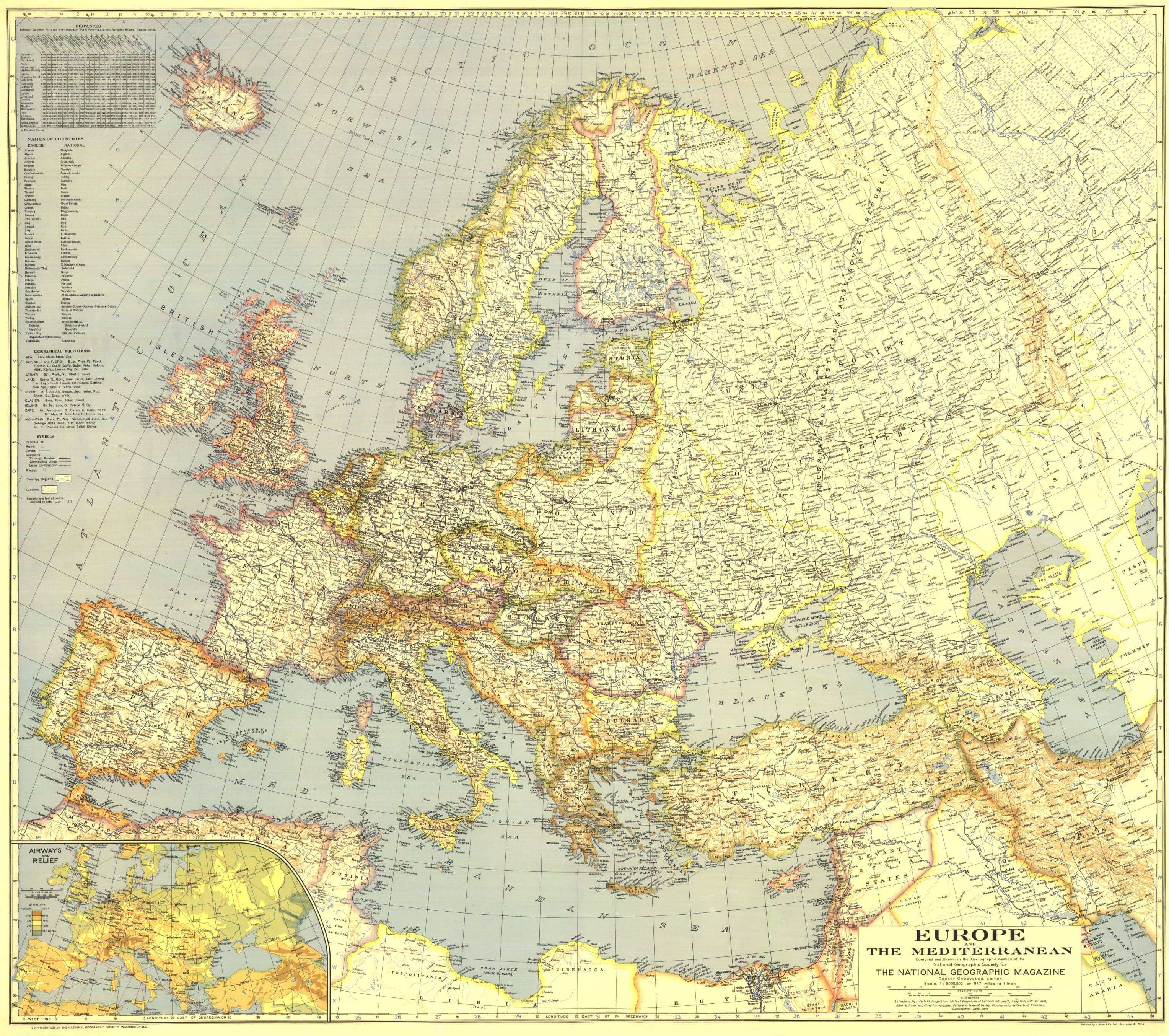
A continent and its inland sea on the cusp of change. Published in April 1938, this evocative Europe and the Mediterranean wall map captures the final calm before World War II—ports busy with commerce, borders still fixed in pre-war alignments, and cultural spheres circling the great sea that bound them together. It’s a richly coloured, period-true composition that commands a wall from across the room and rewards close study at arm’s length.
A distinctive feature of this edition is its bilingual treatment of nations—country names shown in English and in the national language—a cartographic courtesy that invites you to read the map as Europe saw itself. Clarity of line, elegant typography, and careful symbol hierarchy make it both reference and artefact.
More Than a Map – A Testament to History
This isn’t just wall art—it’s a frame for understanding Europe in 1938. Borders, capitals, city networks, and Mediterranean linkages reveal a civilisation poised between continuity and upheaval. Ideal for educators, planners, historians, designers, and collectors, it pairs beautifully with other interwar National Geographic maps for thematic displays and comparative study.
Hang it in studios, libraries, classrooms, museums, offices, or at home to invite reflection, study, and conversation.
Premium Materials & Finishes
We treat history with the respect it deserves. That’s why we offer multiple formats, each produced using high-quality materials and modern archival printing.
🌟 Archival Paper Print
Printed on heavyweight 160gsm archival-grade paper.
Smooth matte finish reduces glare and preserves fine linework and small labels.
Ideal for framing under glass—clean, timeless, and built to last.
💎 Laminated Edition
Encapsulated in two sheets of 80-micron gloss laminate using true thermal bonding—not just surface lamination.
Moisture-resistant, wipe-clean surface—perfect for classrooms and high-traffic reference spaces.
Optional Natural Timber Hang Rails: lacquered rails with a fitted hanging cord provide a polished, ready-to-hang presentation—no frame required. (Please allow up to 10 working days for delivery with hang rails.)
🏆 Museum-Quality Canvas
Printed on heavyweight 395gsm HP Professional Matte Canvas for rich texture and exceptional strength.
Pigment-based, fade-resistant inks deliver deep tone and crisp typography that endure for generations.
Optional Natural Timber Hang Rails: lacquered to enhance the wood grain and protect against wear; top cord for effortless hanging—elegant in any setting. (Please allow up to 10 working days for delivery with hang rails.)
Specifications
| Feature | Details |
|---|---|
| Title | Europe and the Mediterranean |
| Series | National Geographic single-sheet regional map |
| Original Publication | 1938 (April) |
| Scale | 1:6,000,000 |
| Cartographic Content | Countries; capitals & major cities; borders; coastlines; Mediterranean linkages; bilingual country names (English & national language) |
| Map Size | 968 mm (W) × 857 mm (H) |
| Available Formats | Paper, Laminated, Canvas |
| Paper Weight | 160gsm archival-quality |
| Laminate | 2 × 80-micron gloss laminate sheets (encapsulated) |
| Canvas Weight | 395gsm HP Professional Matte Canvas |
| Inks | Pigment-based, fade-resistant |
| Optional Hang Rails | Available on Laminated & Canvas (lead time up to 10 working days) |
| Origin | Printed in Australia |
Why Choose This Map
✔ Era-True Snapshot: Europe and the Mediterranean exactly as mapped in 1938, on the eve of war.
✔ Bilingual Detail: Country names presented in English and national languages—a rare, humanising touch.
✔ Clarity at Scale: Balanced design for room-distance impact and rewarding close study.
✔ Decorative & Scholarly: Equally at home in living spaces, offices, and classrooms.
✔ Archival Craft: Premium substrates and inks preserve contrast, labels, and linework for decades.
Our Commitment
We believe that preserving history is as important as telling it. Every map is printed locally in Australia using state-of-the-art technology, carefully checked by hand, and packed with care. From the moment it leaves our workshop to the day it hangs on your wall, we ensure quality you can trust and a legacy you’ll be proud to share.
Bring interwar Europe into focus—order the Europe and the Mediterranean Wall Map (1938) and turn your space into a conversation.
Original: $50.05
-65%$50.05
$17.52Product Information
Product Information
Shipping & Returns
Shipping & Returns
Description
Europe and the Mediterranean — National Geographic Wall Map (1938)
A continent and its inland sea on the cusp of change. Published in April 1938, this evocative Europe and the Mediterranean wall map captures the final calm before World War II—ports busy with commerce, borders still fixed in pre-war alignments, and cultural spheres circling the great sea that bound them together. It’s a richly coloured, period-true composition that commands a wall from across the room and rewards close study at arm’s length.
A distinctive feature of this edition is its bilingual treatment of nations—country names shown in English and in the national language—a cartographic courtesy that invites you to read the map as Europe saw itself. Clarity of line, elegant typography, and careful symbol hierarchy make it both reference and artefact.
More Than a Map – A Testament to History
This isn’t just wall art—it’s a frame for understanding Europe in 1938. Borders, capitals, city networks, and Mediterranean linkages reveal a civilisation poised between continuity and upheaval. Ideal for educators, planners, historians, designers, and collectors, it pairs beautifully with other interwar National Geographic maps for thematic displays and comparative study.
Hang it in studios, libraries, classrooms, museums, offices, or at home to invite reflection, study, and conversation.
Premium Materials & Finishes
We treat history with the respect it deserves. That’s why we offer multiple formats, each produced using high-quality materials and modern archival printing.
🌟 Archival Paper Print
Printed on heavyweight 160gsm archival-grade paper.
Smooth matte finish reduces glare and preserves fine linework and small labels.
Ideal for framing under glass—clean, timeless, and built to last.
💎 Laminated Edition
Encapsulated in two sheets of 80-micron gloss laminate using true thermal bonding—not just surface lamination.
Moisture-resistant, wipe-clean surface—perfect for classrooms and high-traffic reference spaces.
Optional Natural Timber Hang Rails: lacquered rails with a fitted hanging cord provide a polished, ready-to-hang presentation—no frame required. (Please allow up to 10 working days for delivery with hang rails.)
🏆 Museum-Quality Canvas
Printed on heavyweight 395gsm HP Professional Matte Canvas for rich texture and exceptional strength.
Pigment-based, fade-resistant inks deliver deep tone and crisp typography that endure for generations.
Optional Natural Timber Hang Rails: lacquered to enhance the wood grain and protect against wear; top cord for effortless hanging—elegant in any setting. (Please allow up to 10 working days for delivery with hang rails.)
Specifications
| Feature | Details |
|---|---|
| Title | Europe and the Mediterranean |
| Series | National Geographic single-sheet regional map |
| Original Publication | 1938 (April) |
| Scale | 1:6,000,000 |
| Cartographic Content | Countries; capitals & major cities; borders; coastlines; Mediterranean linkages; bilingual country names (English & national language) |
| Map Size | 968 mm (W) × 857 mm (H) |
| Available Formats | Paper, Laminated, Canvas |
| Paper Weight | 160gsm archival-quality |
| Laminate | 2 × 80-micron gloss laminate sheets (encapsulated) |
| Canvas Weight | 395gsm HP Professional Matte Canvas |
| Inks | Pigment-based, fade-resistant |
| Optional Hang Rails | Available on Laminated & Canvas (lead time up to 10 working days) |
| Origin | Printed in Australia |
Why Choose This Map
✔ Era-True Snapshot: Europe and the Mediterranean exactly as mapped in 1938, on the eve of war.
✔ Bilingual Detail: Country names presented in English and national languages—a rare, humanising touch.
✔ Clarity at Scale: Balanced design for room-distance impact and rewarding close study.
✔ Decorative & Scholarly: Equally at home in living spaces, offices, and classrooms.
✔ Archival Craft: Premium substrates and inks preserve contrast, labels, and linework for decades.
Our Commitment
We believe that preserving history is as important as telling it. Every map is printed locally in Australia using state-of-the-art technology, carefully checked by hand, and packed with care. From the moment it leaves our workshop to the day it hangs on your wall, we ensure quality you can trust and a legacy you’ll be proud to share.
Bring interwar Europe into focus—order the Europe and the Mediterranean Wall Map (1938) and turn your space into a conversation.


