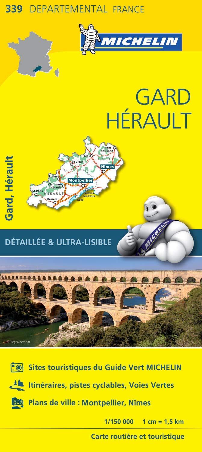
France Gard / Hérault Michelin Map 339
Explore Southern France in Unmatched Detail
Scale: 1:150,000 | Size: 1200 mm x 1000 mm
Order on demand – please allow 7–10 working days for delivery
🗺️ Overview
Uncover the historic heart of southern France with Michelin Map 339 – Gard / Hérault, the most detailed regional road map available for this enchanting corner of the Occitanie region. At a scale of 1:150,000, this map reveals every minor road, village, and scenic byway—ideal for slow travel, in-depth exploration, and discovering the lesser-known highlights of the French countryside.
From Roman amphitheatres in Nîmes to the sunlit vineyards near Béziers, this map is your essential companion for navigating the region with confidence and curiosity.
✅ Key Features
| Feature | Benefit |
|---|---|
| Highly Detailed Road Network | Includes major routes, regional roads, and tiny rural lanes |
| Village-Level Cartography | Every town, village, and hamlet is clearly marked |
| Comprehensive Index | Easily locate places of interest using the full place-name index |
| Distance Calculator Chart | Plan out your daily drives with simple, quick reference |
| Touring-Optimised Scale | 1:150,000 scale offers an excellent balance of coverage and clarity |
| Trusted Michelin Cartography | Renowned for its clarity, reliability, and precision |
A Region Rich with Discovery
Covering the full Gard and Hérault départements, this map guides you through one of France’s most culturally and geographically diverse areas:
-
Visit UNESCO-listed cities like Montpellier and Nîmes
-
Explore the Camargue wetlands, Cevennes mountains, and the Mediterranean coastline
-
Find small towns and local routes not shown on most digital maps
-
Identify scenic viewpoints, tourist attractions, and natural parks with ease
Whether you're tracing Roman roads, wine touring, or venturing off the beaten track, this map ensures no hidden gem is left undiscovered.
📐 Product Specifications
-
Title: Michelin Regional Map 339 – Gard / Hérault
-
Scale: 1:150,000
-
Size: 1200 mm x 1000 mm (unfolded)
-
Finish: Paper (folded or suitable for framing)
-
Indexed: Yes – includes a full place-name index
-
Publisher: Michelin – France’s most trusted mapmaker
-
Delivery: Order on demand – please allow 7–10 working days
Perfect For:
-
Self-guided travellers and road trippers
-
Holidaymakers seeking authentic local experiences
-
Caravan and campervan travellers exploring France’s south
-
Cyclists and walkers navigating regional backroads
-
Francophiles, educators, and map enthusiasts
Plan, Discover, and Explore with Michelin Map 339
Whether you're sipping wine in Uzès, sunbathing near Sète, or exploring the Gorges of the Hérault, this regional map is your key to travelling with depth, precision, and delight. With its trademark clarity and detail, Michelin’s Map 339 lets you turn a holiday into a true adventure.
Add to your cart today and experience Gard and Hérault the Michelin way—through the roads less travelled.
Original: $17.85
-65%$17.85
$6.25Product Information
Product Information
Shipping & Returns
Shipping & Returns
Description
Explore Southern France in Unmatched Detail
Scale: 1:150,000 | Size: 1200 mm x 1000 mm
Order on demand – please allow 7–10 working days for delivery
🗺️ Overview
Uncover the historic heart of southern France with Michelin Map 339 – Gard / Hérault, the most detailed regional road map available for this enchanting corner of the Occitanie region. At a scale of 1:150,000, this map reveals every minor road, village, and scenic byway—ideal for slow travel, in-depth exploration, and discovering the lesser-known highlights of the French countryside.
From Roman amphitheatres in Nîmes to the sunlit vineyards near Béziers, this map is your essential companion for navigating the region with confidence and curiosity.
✅ Key Features
| Feature | Benefit |
|---|---|
| Highly Detailed Road Network | Includes major routes, regional roads, and tiny rural lanes |
| Village-Level Cartography | Every town, village, and hamlet is clearly marked |
| Comprehensive Index | Easily locate places of interest using the full place-name index |
| Distance Calculator Chart | Plan out your daily drives with simple, quick reference |
| Touring-Optimised Scale | 1:150,000 scale offers an excellent balance of coverage and clarity |
| Trusted Michelin Cartography | Renowned for its clarity, reliability, and precision |
A Region Rich with Discovery
Covering the full Gard and Hérault départements, this map guides you through one of France’s most culturally and geographically diverse areas:
-
Visit UNESCO-listed cities like Montpellier and Nîmes
-
Explore the Camargue wetlands, Cevennes mountains, and the Mediterranean coastline
-
Find small towns and local routes not shown on most digital maps
-
Identify scenic viewpoints, tourist attractions, and natural parks with ease
Whether you're tracing Roman roads, wine touring, or venturing off the beaten track, this map ensures no hidden gem is left undiscovered.
📐 Product Specifications
-
Title: Michelin Regional Map 339 – Gard / Hérault
-
Scale: 1:150,000
-
Size: 1200 mm x 1000 mm (unfolded)
-
Finish: Paper (folded or suitable for framing)
-
Indexed: Yes – includes a full place-name index
-
Publisher: Michelin – France’s most trusted mapmaker
-
Delivery: Order on demand – please allow 7–10 working days
Perfect For:
-
Self-guided travellers and road trippers
-
Holidaymakers seeking authentic local experiences
-
Caravan and campervan travellers exploring France’s south
-
Cyclists and walkers navigating regional backroads
-
Francophiles, educators, and map enthusiasts
Plan, Discover, and Explore with Michelin Map 339
Whether you're sipping wine in Uzès, sunbathing near Sète, or exploring the Gorges of the Hérault, this regional map is your key to travelling with depth, precision, and delight. With its trademark clarity and detail, Michelin’s Map 339 lets you turn a holiday into a true adventure.
Add to your cart today and experience Gard and Hérault the Michelin way—through the roads less travelled.


