Fraser Island Atlas & Guide Hema
Your Essential Companion to Queensland’s Iconic Sand Islands
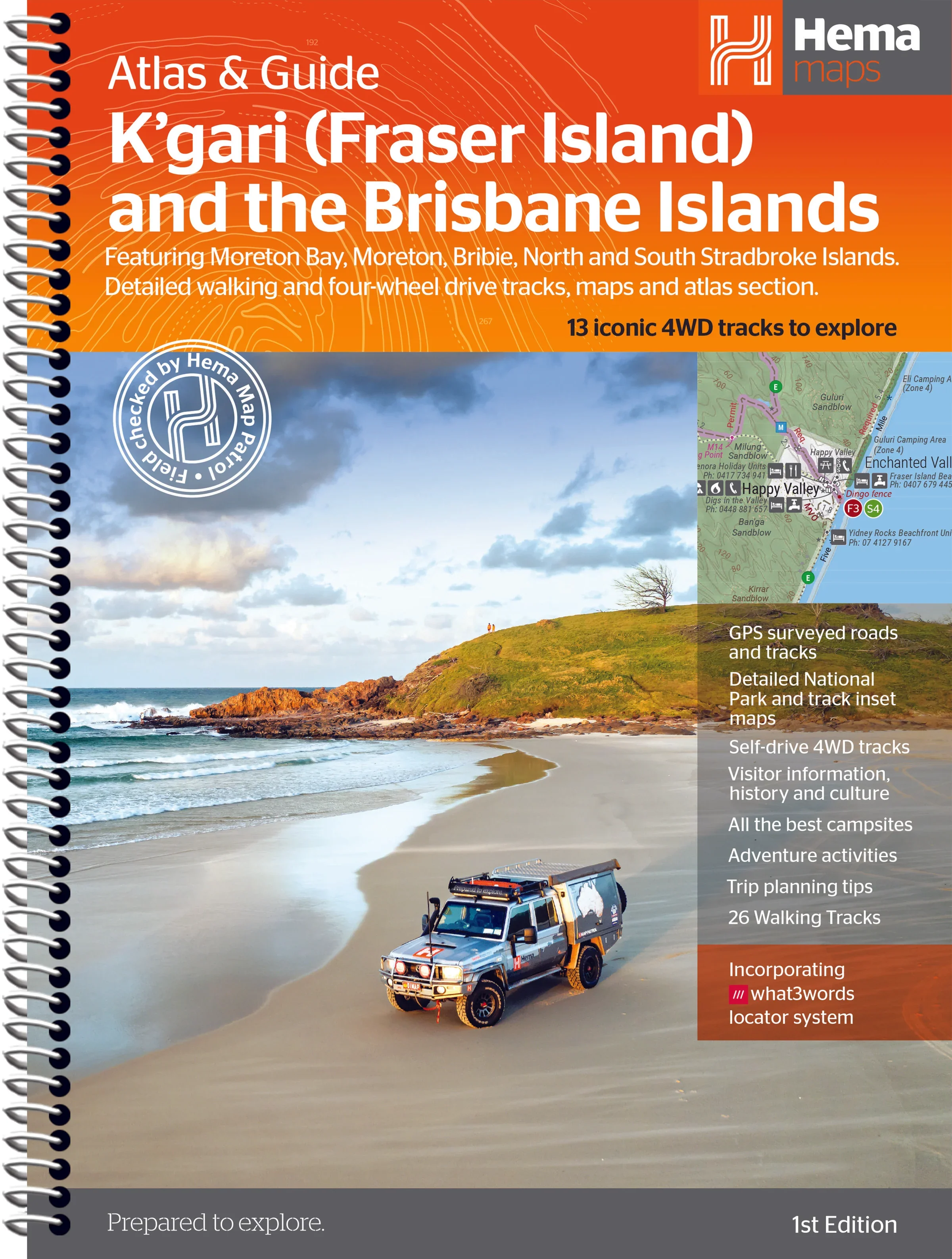
Explore the natural wonders, cultural heritage, and off-road adventures of Australia’s most celebrated sand islands with the K’gari (Fraser Island) & Brisbane Islands Atlas & Guide by Hema Maps. Whether you're a seasoned four-wheel driver, a curious bushwalker, or a coastal explorer, this beautifully crafted atlas is your ticket to discovering the full breadth of Queensland’s island jewels.
Authored by travel writer Chris Whitelaw and backed by Hema’s field-verified cartography, this guide combines expert local knowledge with unrivalled detail—perfect for both trip planning and on-the-ground navigation.
🏝️ Destinations Covered
This comprehensive guide explores:
-
K’gari (Fraser Island) – The world’s largest sand island, known for its crystal-clear lakes, rainforest trails, and dingo-populated beaches
-
Moreton Island – Home to the famous Tangalooma Wrecks and dramatic sand dunes
-
North Stradbroke Island (Minjerribah) – A cultural and scenic gem with pristine surf beaches and walking tracks
-
South Stradbroke Island – A peaceful retreat with rugged charm
-
Bribie Island – The closest island escape to Brisbane, with great 4WD beach access and calm waters
🗺️ Atlas & Mapping Highlights
-
Hema Maps’ trusted cartography — with clearly marked roads, 4WD tracks, topographic features, campsites, and facilities
-
Detailed 4WD track mapping and bushwalking trail coverage across all five islands
-
13 epic 4WD adventures mapped and described in detail, with grading, trip notes, and longest fuel-free distances
-
26 bushwalking tracks, each with trail notes and natural highlights
-
Comprehensive road atlas section of each island for easy reference and trip planning
📚 What You’ll Learn and Discover
| Feature | Details |
|---|---|
| 🌿 Nature & Ecosystems | Learn about island biodiversity, unique geology, dune systems, and coastal habitats |
| 📖 Cultural Heritage | Insight into Indigenous stories and historical landmarks across the islands |
| 🛠️ Practical Planning Tools | Campsite info, permits, facilities, access points, picnic areas, and safety advice |
| 📍 Must-See Attractions | Lakes, lookouts, shipwrecks, walking tracks, and secret spots you won’t want to miss |
🚗 Who This Guide is For
-
4WD enthusiasts seeking off-grid tracks and iconic routes like Sandy Cape, Lake McKenzie, and more
-
Bushwalkers and hikers exploring rainforest trails and coastal cliffs
-
Family travellers planning camping trips with reliable facility and access info
-
Eco-tourists and heritage seekers looking for meaningful connection with land and culture
-
Photographers and nature lovers chasing the golden hour across dunes and inland lakes
📘 Key Specifications
| Specification | Detail |
|---|---|
| Format | Softcover atlas & guide |
| Pages | Full-colour throughout, packed with maps, images, and informative text |
| Mapping | Hema Maps’ award-winning field-checked cartography |
| Size | Large-format for easy readability in-vehicle or at the campsite |
| Edition | Latest available edition by Hema Maps |
🌊 Why Choose This Guide
✅ All-in-one – navigation, history, culture, and track notes
✅ Field-verified – Hema’s Map Patrol has driven and walked the routes
✅ Beautifully illustrated – full-colour maps, images, and layout
✅ Essential for planning, exploring, and preserving the magic of these islands
Whether you're standing atop the dunes of Moreton, floating in the waters of Eli Creek, or following ancient pathways through the forests of K’gari, this guide will be your trusted companion—before, during, and after your journey.
Unfold the magic of Queensland’s coastal wilderness. Let the adventure begin.
Original: $35.74
-65%$35.74
$12.51Product Information
Product Information
Shipping & Returns
Shipping & Returns
Description
Your Essential Companion to Queensland’s Iconic Sand Islands
Explore the natural wonders, cultural heritage, and off-road adventures of Australia’s most celebrated sand islands with the K’gari (Fraser Island) & Brisbane Islands Atlas & Guide by Hema Maps. Whether you're a seasoned four-wheel driver, a curious bushwalker, or a coastal explorer, this beautifully crafted atlas is your ticket to discovering the full breadth of Queensland’s island jewels.
Authored by travel writer Chris Whitelaw and backed by Hema’s field-verified cartography, this guide combines expert local knowledge with unrivalled detail—perfect for both trip planning and on-the-ground navigation.
🏝️ Destinations Covered
This comprehensive guide explores:
-
K’gari (Fraser Island) – The world’s largest sand island, known for its crystal-clear lakes, rainforest trails, and dingo-populated beaches
-
Moreton Island – Home to the famous Tangalooma Wrecks and dramatic sand dunes
-
North Stradbroke Island (Minjerribah) – A cultural and scenic gem with pristine surf beaches and walking tracks
-
South Stradbroke Island – A peaceful retreat with rugged charm
-
Bribie Island – The closest island escape to Brisbane, with great 4WD beach access and calm waters
🗺️ Atlas & Mapping Highlights
-
Hema Maps’ trusted cartography — with clearly marked roads, 4WD tracks, topographic features, campsites, and facilities
-
Detailed 4WD track mapping and bushwalking trail coverage across all five islands
-
13 epic 4WD adventures mapped and described in detail, with grading, trip notes, and longest fuel-free distances
-
26 bushwalking tracks, each with trail notes and natural highlights
-
Comprehensive road atlas section of each island for easy reference and trip planning
📚 What You’ll Learn and Discover
| Feature | Details |
|---|---|
| 🌿 Nature & Ecosystems | Learn about island biodiversity, unique geology, dune systems, and coastal habitats |
| 📖 Cultural Heritage | Insight into Indigenous stories and historical landmarks across the islands |
| 🛠️ Practical Planning Tools | Campsite info, permits, facilities, access points, picnic areas, and safety advice |
| 📍 Must-See Attractions | Lakes, lookouts, shipwrecks, walking tracks, and secret spots you won’t want to miss |
🚗 Who This Guide is For
-
4WD enthusiasts seeking off-grid tracks and iconic routes like Sandy Cape, Lake McKenzie, and more
-
Bushwalkers and hikers exploring rainforest trails and coastal cliffs
-
Family travellers planning camping trips with reliable facility and access info
-
Eco-tourists and heritage seekers looking for meaningful connection with land and culture
-
Photographers and nature lovers chasing the golden hour across dunes and inland lakes
📘 Key Specifications
| Specification | Detail |
|---|---|
| Format | Softcover atlas & guide |
| Pages | Full-colour throughout, packed with maps, images, and informative text |
| Mapping | Hema Maps’ award-winning field-checked cartography |
| Size | Large-format for easy readability in-vehicle or at the campsite |
| Edition | Latest available edition by Hema Maps |
🌊 Why Choose This Guide
✅ All-in-one – navigation, history, culture, and track notes
✅ Field-verified – Hema’s Map Patrol has driven and walked the routes
✅ Beautifully illustrated – full-colour maps, images, and layout
✅ Essential for planning, exploring, and preserving the magic of these islands
Whether you're standing atop the dunes of Moreton, floating in the waters of Eli Creek, or following ancient pathways through the forests of K’gari, this guide will be your trusted companion—before, during, and after your journey.
Unfold the magic of Queensland’s coastal wilderness. Let the adventure begin.