Geographic Comparisons: Earth's Extremes - Atlas of the World, 10th Edition by National Geographic
Geographic Comparisons: Earth's Extremes - Atlas of the World, 10th Edition by National Geographic
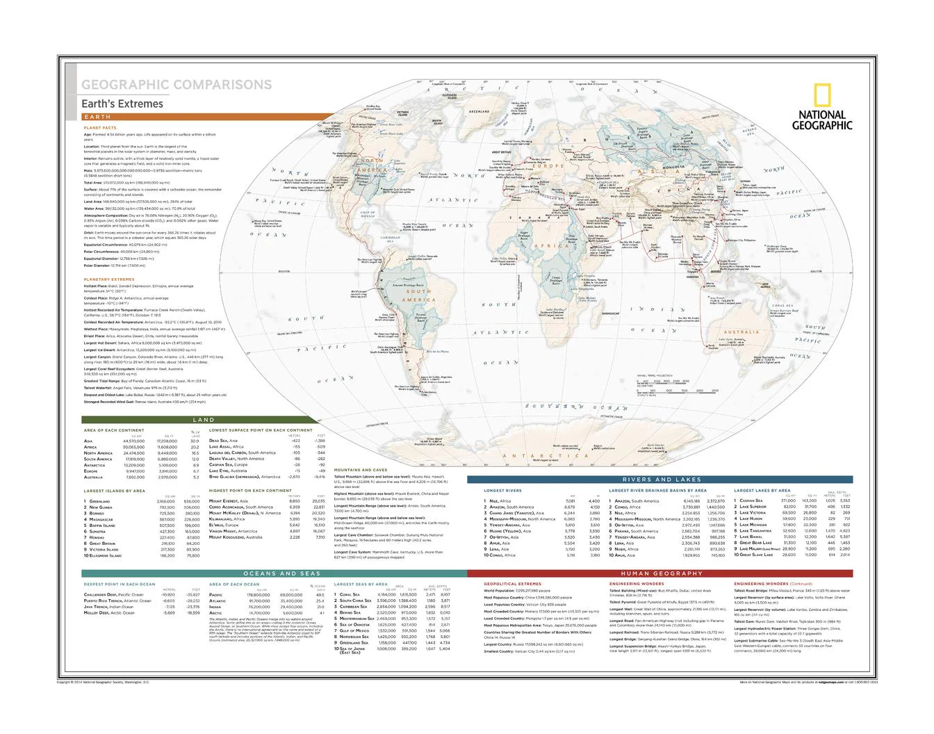
World Thematic Map | Size, Scale & Planetary Extremes | Atlas of the World, 10th Edition (711 × 559 mm) | Premium Finishes
A fascinating visual comparison of the planet’s most dramatic features, Geographic Comparisons: Earth’s Extremes places the scale of our world into sharp perspective. Published by National Geographic as part of the Atlas of the World, 10th Edition (Plate 143), this map transforms geography into a powerful study of size, elevation, depth, and spatial relationships.
From towering mountain ranges to vast deserts and deep ocean trenches, it reveals how Earth’s extremes compare—side by side—in a way that is both educational and visually striking.
Why This Map Stands Out
A new way to see the planet
Presents Earth’s most extreme features through direct visual comparison.
Scale made intuitive
Helps you understand the true size of mountains, basins, and geographic regions.
Atlas-level authority
Drawn from National Geographic’s flagship atlas—precise, clear, and beautifully designed.
Engaging and educational
Ideal for both casual exploration and deeper geographic understanding.
A compelling wall display
Balances scientific insight with strong visual appeal.
🗺️ What the Map Shows
- Comparisons of Earth’s highest, lowest, largest, and most extreme features
- Relative scale of mountain ranges, plateaus, basins, and ocean depths
- Visual relationships between major geographic landmarks across continents
- Elevation and depth contrasts presented in an accessible format
- A global perspective on how Earth’s landscapes vary dramatically in scale
📐 Size & Format
711 mm (W) × 559 mm (H)
Landscape orientation
A balanced format ideal for:
- Classrooms and educational spaces
- Home offices and studies
- Libraries and research environments
- Interiors focused on geography and exploration
✨ Premium Finishes
| Format | Description |
|---|---|
| 📜 Paper (160 gsm) | Heavyweight matte-coated paper—ideal for framing. Preserves crisp detail and clarity. |
| 🧼 Laminated (Encapsulated) | Sealed in 2 × 80-micron gloss laminate. Durable, wipe-clean, and suitable for frequent reference. |
| 🪵 Laminated + Timber Hang Rails | Laminated map mounted with lacquered natural timber rails and hanging cord—ready to display. |
| 🖼️ Canvas (395 gsm HP Professional Matte) | Printed with archival pigment inks. Rich texture enhances depth and presentation. |
| 🪵 Canvas + Timber Hang Rails | Canvas paired with timber rails for a refined, gallery-style display. |
🔨 Please allow up to 10 working days for professionally mounted hang-railed finishes.
📊 Specifications
| Feature | Detail |
|---|---|
| Title | Geographic Comparisons: Earth’s Extremes |
| Publisher | National Geographic |
| Published | 25 February 2015 |
| Source | Atlas of the World, 10th Edition (Plate 143) |
| Dimensions | 711 mm × 559 mm |
| Orientation | Landscape |
| Map Type | Thematic / Comparative |
| Focus | Geographic scale, elevation, depth, extremes |
| Materials | 160 gsm matte paper / 2 × 80-micron laminate / 395 gsm HP Professional Matte Canvas |
| Printing | Pigment-based, fade-resistant inks |
| Origin | Printed in Australia |
🎯 Ideal For
- Students and educators of geography and earth science
- Enthusiasts of physical geography and global exploration
- Offices and classrooms needing a clear comparative reference
- Interiors seeking a visually engaging educational display
- Gift buyers looking for a unique and insightful map
🌍 Seeing Earth in Perspective
This map reveals the true scale of our planet:
- Mountains rising far higher than we imagine
- Ocean depths plunging beyond easy comprehension
- Landscapes that vary dramatically across continents
- A world where scale shapes how we understand geography
It’s a reminder that Earth is not just diverse—but extraordinary in its extremes.
🤝 Our Commitment
- Printed in Australia using archival-quality production
- Faithfully reproduced to preserve clarity and detail
- Premium materials selected for durability and long-term display
- Each map is hand-checked before dispatch
- Carefully packaged for safe delivery
🚚 Delivery
- Paper, Laminated, Canvas (rolled): Dispatch within 1–2 business days
- Hang-Railed Maps: Made to order—allow up to 10 working days
- Packaging: Securely rolled in protective tubing
See the planet from a new perspective—
a map that brings Earth’s extremes into clear, visual comparison.
👉 Order now and experience geography at its most dramatic.
Original: $57.20
-65%$57.20
$20.02Product Information
Product Information
Shipping & Returns
Shipping & Returns
Description
World Thematic Map | Size, Scale & Planetary Extremes | Atlas of the World, 10th Edition (711 × 559 mm) | Premium Finishes
A fascinating visual comparison of the planet’s most dramatic features, Geographic Comparisons: Earth’s Extremes places the scale of our world into sharp perspective. Published by National Geographic as part of the Atlas of the World, 10th Edition (Plate 143), this map transforms geography into a powerful study of size, elevation, depth, and spatial relationships.
From towering mountain ranges to vast deserts and deep ocean trenches, it reveals how Earth’s extremes compare—side by side—in a way that is both educational and visually striking.
Why This Map Stands Out
A new way to see the planet
Presents Earth’s most extreme features through direct visual comparison.
Scale made intuitive
Helps you understand the true size of mountains, basins, and geographic regions.
Atlas-level authority
Drawn from National Geographic’s flagship atlas—precise, clear, and beautifully designed.
Engaging and educational
Ideal for both casual exploration and deeper geographic understanding.
A compelling wall display
Balances scientific insight with strong visual appeal.
🗺️ What the Map Shows
- Comparisons of Earth’s highest, lowest, largest, and most extreme features
- Relative scale of mountain ranges, plateaus, basins, and ocean depths
- Visual relationships between major geographic landmarks across continents
- Elevation and depth contrasts presented in an accessible format
- A global perspective on how Earth’s landscapes vary dramatically in scale
📐 Size & Format
711 mm (W) × 559 mm (H)
Landscape orientation
A balanced format ideal for:
- Classrooms and educational spaces
- Home offices and studies
- Libraries and research environments
- Interiors focused on geography and exploration
✨ Premium Finishes
| Format | Description |
|---|---|
| 📜 Paper (160 gsm) | Heavyweight matte-coated paper—ideal for framing. Preserves crisp detail and clarity. |
| 🧼 Laminated (Encapsulated) | Sealed in 2 × 80-micron gloss laminate. Durable, wipe-clean, and suitable for frequent reference. |
| 🪵 Laminated + Timber Hang Rails | Laminated map mounted with lacquered natural timber rails and hanging cord—ready to display. |
| 🖼️ Canvas (395 gsm HP Professional Matte) | Printed with archival pigment inks. Rich texture enhances depth and presentation. |
| 🪵 Canvas + Timber Hang Rails | Canvas paired with timber rails for a refined, gallery-style display. |
🔨 Please allow up to 10 working days for professionally mounted hang-railed finishes.
📊 Specifications
| Feature | Detail |
|---|---|
| Title | Geographic Comparisons: Earth’s Extremes |
| Publisher | National Geographic |
| Published | 25 February 2015 |
| Source | Atlas of the World, 10th Edition (Plate 143) |
| Dimensions | 711 mm × 559 mm |
| Orientation | Landscape |
| Map Type | Thematic / Comparative |
| Focus | Geographic scale, elevation, depth, extremes |
| Materials | 160 gsm matte paper / 2 × 80-micron laminate / 395 gsm HP Professional Matte Canvas |
| Printing | Pigment-based, fade-resistant inks |
| Origin | Printed in Australia |
🎯 Ideal For
- Students and educators of geography and earth science
- Enthusiasts of physical geography and global exploration
- Offices and classrooms needing a clear comparative reference
- Interiors seeking a visually engaging educational display
- Gift buyers looking for a unique and insightful map
🌍 Seeing Earth in Perspective
This map reveals the true scale of our planet:
- Mountains rising far higher than we imagine
- Ocean depths plunging beyond easy comprehension
- Landscapes that vary dramatically across continents
- A world where scale shapes how we understand geography
It’s a reminder that Earth is not just diverse—but extraordinary in its extremes.
🤝 Our Commitment
- Printed in Australia using archival-quality production
- Faithfully reproduced to preserve clarity and detail
- Premium materials selected for durability and long-term display
- Each map is hand-checked before dispatch
- Carefully packaged for safe delivery
🚚 Delivery
- Paper, Laminated, Canvas (rolled): Dispatch within 1–2 business days
- Hang-Railed Maps: Made to order—allow up to 10 working days
- Packaging: Securely rolled in protective tubing
See the planet from a new perspective—
a map that brings Earth’s extremes into clear, visual comparison.
👉 Order now and experience geography at its most dramatic.


