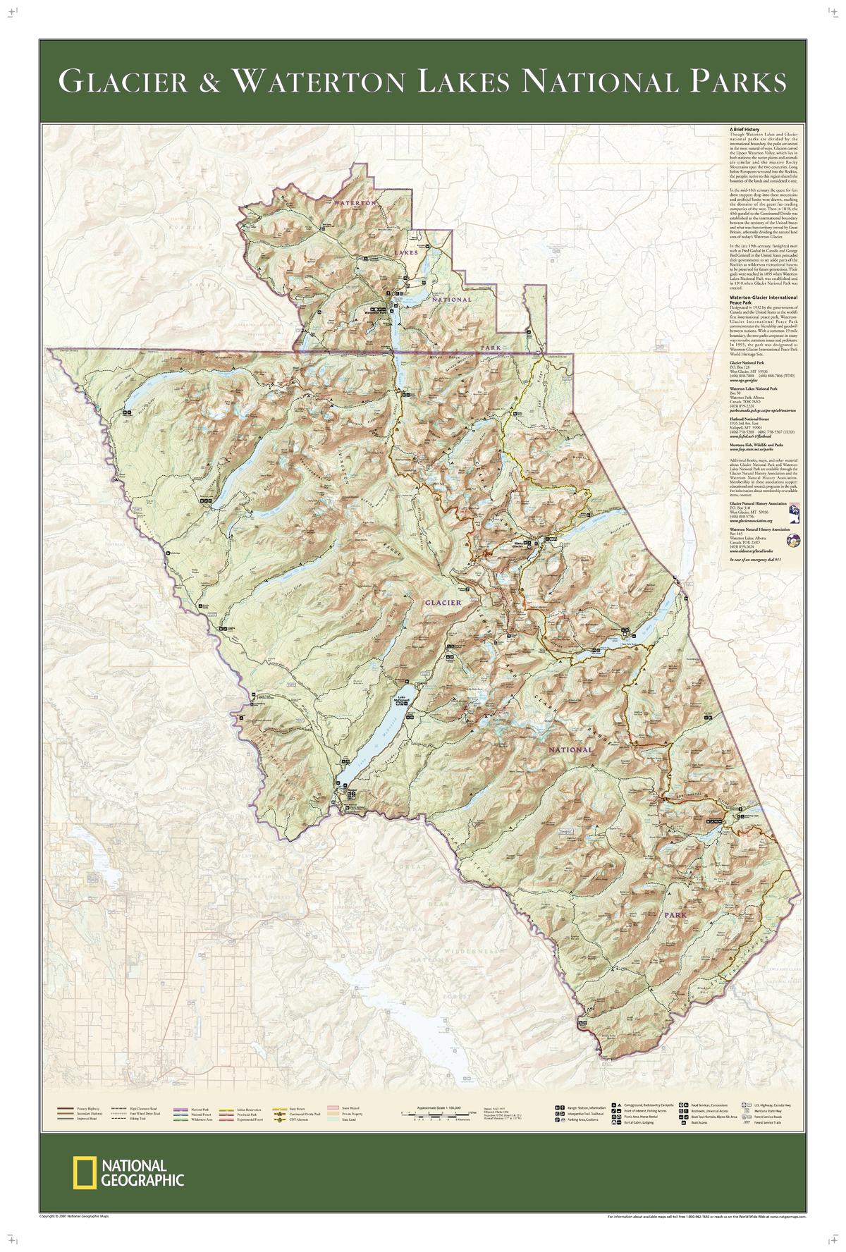
Glacier and Waterton Lakes National Parks by National Geographic
Topographic Wall Map | Crown of the Continent | Large Format (940 × 635 mm) | Premium Finishes
A spectacular topographic map capturing one of North America’s most breathtaking mountain regions, Glacier & Waterton Lakes National Parks brings the “Crown of the Continent” into sharp, detailed focus. Published by National Geographic and based on the trusted Trails Illustrated series, this wall map combines precision mapping with rich terrain detail across the borderlands of Montana (USA) and Alberta (Canada).
From rugged peaks and glacial valleys to alpine lakes and forested slopes, it offers both an accurate planning tool and a striking visual display.
Why This Map Stands Out
A world-class mountain landscape
Covers both Glacier National Park and Waterton Lakes National Park—together forming an internationally recognised wilderness.
Trail and road accuracy
Updated routes and access points make it ideal for trip planning and navigation.
Exceptional topographic detail
Contours, elevation shading, and terrain features bring the landscape to life.
Based on Trails Illustrated mapping
Trusted by hikers and outdoor enthusiasts worldwide.
A stunning wall map
Equally suited for practical use or as a feature display piece.
🗺️ What the Map Shows
- Detailed topography of the Glacier–Waterton region
- Major and minor trails, hiking routes, and backcountry paths
- Road networks including scenic drives and access points
- Lakes, rivers, glaciers, and mountain ranges
- Campsites, visitor areas, and key points of interest
- Cross-border continuity between the United States and Canada
- The full scope of the “Crown of the Continent” ecosystem
📐 Size & Format
940 mm (W) × 635 mm (H)
Landscape orientation
A large, highly readable format ideal for:
- Trip planning and route visualisation
- Outdoor enthusiasts and hikers
- Offices and adventure-themed interiors
- Feature walls celebrating wilderness landscapes
✨ Premium Finishes
| Format | Description |
|---|---|
| 📜 Paper (160 gsm) | Heavyweight matte-coated paper—ideal for framing. Preserves fine topographic detail. |
| 🧼 Laminated (Encapsulated) | Sealed in 2 × 80-micron gloss laminate. Durable, wipe-clean, and perfect for planning use. |
| 🪵 Laminated + Timber Hang Rails | Laminated map mounted with lacquered natural timber rails and hanging cord—ready to display. |
| 🖼️ Canvas (395 gsm HP Professional Matte) | Printed with archival pigment inks. Rich texture enhances terrain depth and visual impact. |
| 🪵 Canvas + Timber Hang Rails | Canvas paired with timber rails for a refined, gallery-style presentation. |
🔨 Please allow up to 10 working days for professionally mounted hang-railed finishes.
📊 Specifications
| Feature | Detail |
|---|---|
| Title | Glacier & Waterton Lakes National Parks |
| Publisher | National Geographic |
| Published | 2007 |
| Scale | 1:160,000 |
| Dimensions | 940 mm × 635 mm |
| Orientation | Landscape |
| Map Type | Topographic / Physical |
| Coverage | Montana (USA) & Alberta (Canada) |
| Series | Trails Illustrated (Wall Map Edition) |
| Materials | 160 gsm matte paper / 2 × 80-micron laminate / 395 gsm HP Professional Matte Canvas |
| Printing | Pigment-based, fade-resistant inks |
| Origin | Printed in Australia |
🎯 Ideal For
- Hikers and outdoor enthusiasts planning Glacier–Waterton adventures
- Campers, trekkers, and nature lovers
- Educators and students of physical geography
- Interiors inspired by mountain landscapes and wilderness
- Gift buyers seeking a practical and beautiful map
🏔️ The Crown of the Continent
This region is defined by scale and beauty:
- Glacially carved valleys and rugged peaks
- Pristine alpine lakes and river systems
- A cross-border ecosystem rich in biodiversity
- Trails that wind through one of North America’s most iconic landscapes
This map captures that experience—offering both guidance and inspiration for exploring the wild.
🤝 Our Commitment
- Printed in Australia using archival-quality production
- Faithfully reproduced to preserve topographic clarity and detail
- Premium materials selected for durability and long-term display
- Each map is hand-checked before dispatch
- Carefully packaged for safe delivery
🚚 Delivery
- Paper, Laminated, Canvas (rolled): Dispatch within 1–2 business days
- Hang-Railed Maps: Made to order—allow up to 10 working days
- Packaging: Securely rolled in protective tubing
Plan your next adventure—or relive past journeys—
a map that brings the Crown of the Continent into vivid detail.
👉 Order now and explore one of North America’s greatest wilderness regions.
Original: $57.20
-65%$57.20
$20.02Product Information
Product Information
Shipping & Returns
Shipping & Returns
Description
Topographic Wall Map | Crown of the Continent | Large Format (940 × 635 mm) | Premium Finishes
A spectacular topographic map capturing one of North America’s most breathtaking mountain regions, Glacier & Waterton Lakes National Parks brings the “Crown of the Continent” into sharp, detailed focus. Published by National Geographic and based on the trusted Trails Illustrated series, this wall map combines precision mapping with rich terrain detail across the borderlands of Montana (USA) and Alberta (Canada).
From rugged peaks and glacial valleys to alpine lakes and forested slopes, it offers both an accurate planning tool and a striking visual display.
Why This Map Stands Out
A world-class mountain landscape
Covers both Glacier National Park and Waterton Lakes National Park—together forming an internationally recognised wilderness.
Trail and road accuracy
Updated routes and access points make it ideal for trip planning and navigation.
Exceptional topographic detail
Contours, elevation shading, and terrain features bring the landscape to life.
Based on Trails Illustrated mapping
Trusted by hikers and outdoor enthusiasts worldwide.
A stunning wall map
Equally suited for practical use or as a feature display piece.
🗺️ What the Map Shows
- Detailed topography of the Glacier–Waterton region
- Major and minor trails, hiking routes, and backcountry paths
- Road networks including scenic drives and access points
- Lakes, rivers, glaciers, and mountain ranges
- Campsites, visitor areas, and key points of interest
- Cross-border continuity between the United States and Canada
- The full scope of the “Crown of the Continent” ecosystem
📐 Size & Format
940 mm (W) × 635 mm (H)
Landscape orientation
A large, highly readable format ideal for:
- Trip planning and route visualisation
- Outdoor enthusiasts and hikers
- Offices and adventure-themed interiors
- Feature walls celebrating wilderness landscapes
✨ Premium Finishes
| Format | Description |
|---|---|
| 📜 Paper (160 gsm) | Heavyweight matte-coated paper—ideal for framing. Preserves fine topographic detail. |
| 🧼 Laminated (Encapsulated) | Sealed in 2 × 80-micron gloss laminate. Durable, wipe-clean, and perfect for planning use. |
| 🪵 Laminated + Timber Hang Rails | Laminated map mounted with lacquered natural timber rails and hanging cord—ready to display. |
| 🖼️ Canvas (395 gsm HP Professional Matte) | Printed with archival pigment inks. Rich texture enhances terrain depth and visual impact. |
| 🪵 Canvas + Timber Hang Rails | Canvas paired with timber rails for a refined, gallery-style presentation. |
🔨 Please allow up to 10 working days for professionally mounted hang-railed finishes.
📊 Specifications
| Feature | Detail |
|---|---|
| Title | Glacier & Waterton Lakes National Parks |
| Publisher | National Geographic |
| Published | 2007 |
| Scale | 1:160,000 |
| Dimensions | 940 mm × 635 mm |
| Orientation | Landscape |
| Map Type | Topographic / Physical |
| Coverage | Montana (USA) & Alberta (Canada) |
| Series | Trails Illustrated (Wall Map Edition) |
| Materials | 160 gsm matte paper / 2 × 80-micron laminate / 395 gsm HP Professional Matte Canvas |
| Printing | Pigment-based, fade-resistant inks |
| Origin | Printed in Australia |
🎯 Ideal For
- Hikers and outdoor enthusiasts planning Glacier–Waterton adventures
- Campers, trekkers, and nature lovers
- Educators and students of physical geography
- Interiors inspired by mountain landscapes and wilderness
- Gift buyers seeking a practical and beautiful map
🏔️ The Crown of the Continent
This region is defined by scale and beauty:
- Glacially carved valleys and rugged peaks
- Pristine alpine lakes and river systems
- A cross-border ecosystem rich in biodiversity
- Trails that wind through one of North America’s most iconic landscapes
This map captures that experience—offering both guidance and inspiration for exploring the wild.
🤝 Our Commitment
- Printed in Australia using archival-quality production
- Faithfully reproduced to preserve topographic clarity and detail
- Premium materials selected for durability and long-term display
- Each map is hand-checked before dispatch
- Carefully packaged for safe delivery
🚚 Delivery
- Paper, Laminated, Canvas (rolled): Dispatch within 1–2 business days
- Hang-Railed Maps: Made to order—allow up to 10 working days
- Packaging: Securely rolled in protective tubing
Plan your next adventure—or relive past journeys—
a map that brings the Crown of the Continent into vivid detail.
👉 Order now and explore one of North America’s greatest wilderness regions.


