Grand Canyon of Colorado - Published 1978 by National Geographic
Satellite Image & Geological Cross-Section | Grand Canyon National Park | Large Wall Format (887 × 568 mm) | Premium Finishes
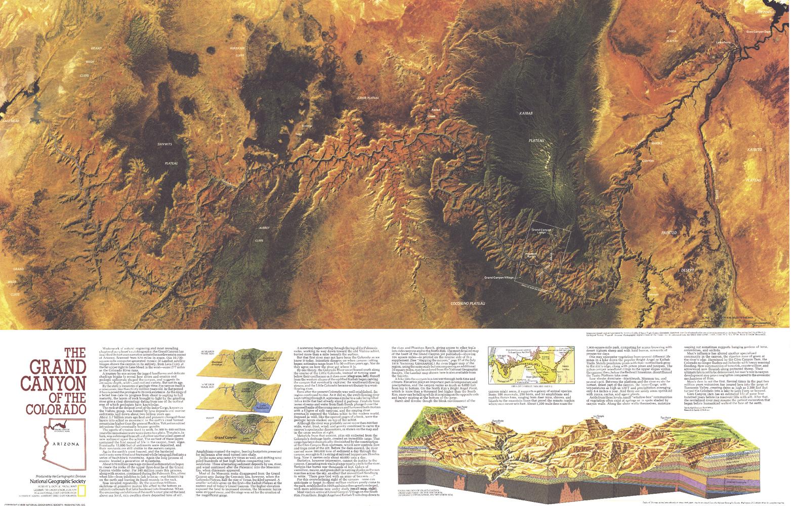
A remarkable fusion of space-age imagery and earth science, Grand Canyon of Colorado reveals one of the world’s greatest natural wonders in extraordinary detail. Published by National Geographic in July 1978, this map pairs a striking Landsat satellite image with a detailed geological cross-section, offering both a surface view and a window into deep time.
Issued as part of a two-map set alongside The Heart of the Grand Canyon, it accompanied National Geographic’s feature coverage of this iconic landscape—bringing together science, scale, and visual impact.
Why This Map Stands Out
A space-age perspective
Features a dramatic Landsat satellite image capturing the full breadth of the canyon.
Reveals what lies beneath
Includes a detailed geological cross-section showing layered rock formations.
Part of a classic National Geographic set
Designed as a companion to The Heart of the Grand Canyon.
Scientific and visually striking
Blends remote sensing with geological interpretation.
A powerful educational display
Perfect for understanding both the surface and structure of the canyon.
🗺️ What the Map Shows
- A high-resolution satellite image of the Grand Canyon region
- The full expanse of Grand Canyon National Park
- The course of the Colorado River carving through the canyon
- A detailed geological cross-section revealing rock layers formed over millions of years
- The relationship between erosion, uplift, and geological time
- A visual connection between landscape and the processes that created it
📐 Size & Format
887 mm (W) × 568 mm (H)
Landscape orientation
A generous wall format ideal for:
- Classrooms and science departments
- Home offices and studies
- Libraries and educational displays
- Interiors inspired by natural landscapes and geology
✨ Premium Finishes
| Format | Description |
|---|---|
| 📜 Paper (160 gsm) | Heavyweight matte-coated paper—ideal for framing. Preserves fine detail and tonal depth. |
| 🧼 Laminated (Encapsulated) | Sealed in 2 × 80-micron gloss laminate. Durable, wipe-clean, and ideal for frequent reference. |
| 🪵 Laminated + Timber Hang Rails | Laminated map mounted with lacquered natural timber rails and hanging cord—ready to display. |
| 🖼️ Canvas (395 gsm HP Professional Matte) | Printed with archival pigment inks. Rich texture enhances depth and visual presence. |
| 🪵 Canvas + Timber Hang Rails | Canvas paired with timber rails for a refined, gallery-style presentation. |
🔨 Please allow up to 10 working days for professionally mounted hang-railed finishes.
📊 Specifications
| Feature | Detail |
|---|---|
| Title | Grand Canyon of Colorado |
| Publisher | National Geographic |
| Published | 1978 |
| Dimensions | 887 mm × 568 mm |
| Orientation | Landscape |
| Map Type | Satellite / Geological / Thematic |
| Coverage | Grand Canyon, Arizona, USA |
| Collections | North America, Historical |
| Materials | 160 gsm matte paper / 2 × 80-micron laminate / 395 gsm HP Professional Matte Canvas |
| Printing | Pigment-based, fade-resistant inks |
| Origin | Printed in Australia |
🎯 Ideal For
- Students and educators of geology and earth science
- Enthusiasts of natural landscapes and national parks
- Collectors of National Geographic scientific maps
- Interiors seeking a dramatic and educational centrepiece
- Gift buyers looking for a unique and visually striking map
🏜️ A Landscape Carved Through Time
The Grand Canyon tells a story written in stone:
- Layers of rock revealing millions of years of Earth’s history
- The Colorado River carving its path through ancient formations
- A landscape shaped by erosion, uplift, and time itself
- A natural wonder that is both vast and deeply detailed
This map captures that story—offering both a bird’s-eye view and a journey beneath the surface.
🤝 Our Commitment
- Printed in Australia using archival-quality production
- Faithfully reproduced to preserve clarity and scientific detail
- Premium materials selected for durability and long-term display
- Each map is hand-checked before dispatch
- Carefully packaged for safe delivery
🚚 Delivery
- Paper, Laminated, Canvas (rolled): Dispatch within 1–2 business days
- Hang-Railed Maps: Made to order—allow up to 10 working days
- Packaging: Securely rolled in protective tubing
Explore one of Earth’s greatest natural wonders—
a map that reveals the Grand Canyon in both scale and depth.
👉 Order now and bring this iconic landscape to your wall.
Original: $57.20
-65%$57.20
$20.02Product Information
Product Information
Shipping & Returns
Shipping & Returns
Description
Satellite Image & Geological Cross-Section | Grand Canyon National Park | Large Wall Format (887 × 568 mm) | Premium Finishes
A remarkable fusion of space-age imagery and earth science, Grand Canyon of Colorado reveals one of the world’s greatest natural wonders in extraordinary detail. Published by National Geographic in July 1978, this map pairs a striking Landsat satellite image with a detailed geological cross-section, offering both a surface view and a window into deep time.
Issued as part of a two-map set alongside The Heart of the Grand Canyon, it accompanied National Geographic’s feature coverage of this iconic landscape—bringing together science, scale, and visual impact.
Why This Map Stands Out
A space-age perspective
Features a dramatic Landsat satellite image capturing the full breadth of the canyon.
Reveals what lies beneath
Includes a detailed geological cross-section showing layered rock formations.
Part of a classic National Geographic set
Designed as a companion to The Heart of the Grand Canyon.
Scientific and visually striking
Blends remote sensing with geological interpretation.
A powerful educational display
Perfect for understanding both the surface and structure of the canyon.
🗺️ What the Map Shows
- A high-resolution satellite image of the Grand Canyon region
- The full expanse of Grand Canyon National Park
- The course of the Colorado River carving through the canyon
- A detailed geological cross-section revealing rock layers formed over millions of years
- The relationship between erosion, uplift, and geological time
- A visual connection between landscape and the processes that created it
📐 Size & Format
887 mm (W) × 568 mm (H)
Landscape orientation
A generous wall format ideal for:
- Classrooms and science departments
- Home offices and studies
- Libraries and educational displays
- Interiors inspired by natural landscapes and geology
✨ Premium Finishes
| Format | Description |
|---|---|
| 📜 Paper (160 gsm) | Heavyweight matte-coated paper—ideal for framing. Preserves fine detail and tonal depth. |
| 🧼 Laminated (Encapsulated) | Sealed in 2 × 80-micron gloss laminate. Durable, wipe-clean, and ideal for frequent reference. |
| 🪵 Laminated + Timber Hang Rails | Laminated map mounted with lacquered natural timber rails and hanging cord—ready to display. |
| 🖼️ Canvas (395 gsm HP Professional Matte) | Printed with archival pigment inks. Rich texture enhances depth and visual presence. |
| 🪵 Canvas + Timber Hang Rails | Canvas paired with timber rails for a refined, gallery-style presentation. |
🔨 Please allow up to 10 working days for professionally mounted hang-railed finishes.
📊 Specifications
| Feature | Detail |
|---|---|
| Title | Grand Canyon of Colorado |
| Publisher | National Geographic |
| Published | 1978 |
| Dimensions | 887 mm × 568 mm |
| Orientation | Landscape |
| Map Type | Satellite / Geological / Thematic |
| Coverage | Grand Canyon, Arizona, USA |
| Collections | North America, Historical |
| Materials | 160 gsm matte paper / 2 × 80-micron laminate / 395 gsm HP Professional Matte Canvas |
| Printing | Pigment-based, fade-resistant inks |
| Origin | Printed in Australia |
🎯 Ideal For
- Students and educators of geology and earth science
- Enthusiasts of natural landscapes and national parks
- Collectors of National Geographic scientific maps
- Interiors seeking a dramatic and educational centrepiece
- Gift buyers looking for a unique and visually striking map
🏜️ A Landscape Carved Through Time
The Grand Canyon tells a story written in stone:
- Layers of rock revealing millions of years of Earth’s history
- The Colorado River carving its path through ancient formations
- A landscape shaped by erosion, uplift, and time itself
- A natural wonder that is both vast and deeply detailed
This map captures that story—offering both a bird’s-eye view and a journey beneath the surface.
🤝 Our Commitment
- Printed in Australia using archival-quality production
- Faithfully reproduced to preserve clarity and scientific detail
- Premium materials selected for durability and long-term display
- Each map is hand-checked before dispatch
- Carefully packaged for safe delivery
🚚 Delivery
- Paper, Laminated, Canvas (rolled): Dispatch within 1–2 business days
- Hang-Railed Maps: Made to order—allow up to 10 working days
- Packaging: Securely rolled in protective tubing
Explore one of Earth’s greatest natural wonders—
a map that reveals the Grand Canyon in both scale and depth.
👉 Order now and bring this iconic landscape to your wall.


