Great Lakes Map Side 1 - Published 1987 by National Geographic
Historical Regional Map | North America’s Freshwater Heartland | Large Wall Format (687 × 516 mm) | Premium Finishes
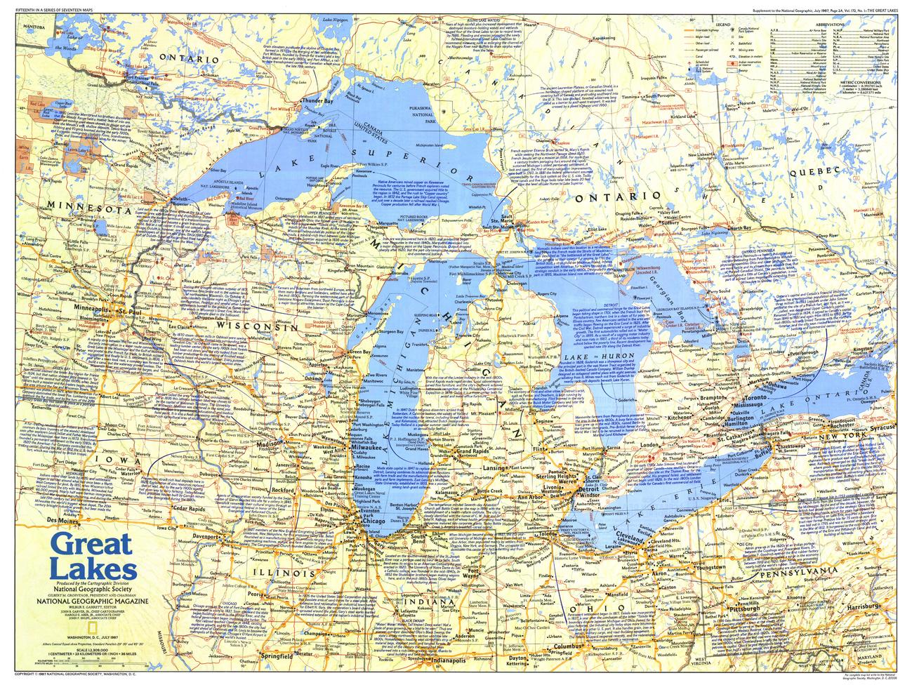
A richly detailed map of one of the world’s most significant freshwater regions, Great Lakes — Map Side 1 captures the scale, history, and geography of North America’s inland seas. Published by National Geographic in July 1987 as part of the Making of America series, it presents a layered view of a region shaped by water, trade, and settlement.
Bordering both Canada and the United States, the Great Lakes form the largest group of freshwater lakes on Earth—an interconnected system that has long been central to transport, industry, and regional identity.
Why This Map Stands Out
A defining North American region
Explores the vast freshwater system linking Canada and the United States.
Part of the “Making of America” series
Places the Great Lakes within the broader historical development of the continent.
Rich historical and cultural detail
Highlights key sites, routes, and places of interest across the region.
National Geographic clarity
Clean, balanced cartography with excellent readability.
A versatile wall map
Ideal for both educational use and decorative display.
🗺️ What the Map Shows
- The five Great Lakes:
- Lake Superior
- Lake Michigan
- Lake Huron
- Lake Erie
- Lake Ontario
- Surrounding regions of Canada and the United States
- Major cities, transport routes, and waterways
- Historical notes and tourist attractions throughout the region
- The interconnected lake system and its geographic relationships
- A regional framework linking water, settlement, and history
📐 Size & Format
687 mm (W) × 516 mm (H)
Landscape orientation
A balanced format ideal for:
- Classrooms and educational settings
- Home offices and studies
- Libraries and regional displays
- Interiors inspired by North American geography
✨ Premium Finishes
| Format | Description |
|---|---|
| 📜 Paper (160 gsm) | Heavyweight matte-coated paper—ideal for framing. Preserves crisp detail and clarity. |
| 🧼 Laminated (Encapsulated) | Sealed in 2 × 80-micron gloss laminate. Durable, wipe-clean, and suitable for frequent reference. |
| 🪵 Laminated + Timber Hang Rails | Laminated map mounted with lacquered natural timber rails and hanging cord—ready to display. |
| 🖼️ Canvas (395 gsm HP Professional Matte) | Printed with archival pigment inks. Rich texture enhances depth and presentation. |
| 🪵 Canvas + Timber Hang Rails | Canvas paired with timber rails for a refined, gallery-style display. |
🔨 Please allow up to 10 working days for professionally mounted hang-railed finishes.
📊 Specifications
| Feature | Detail |
|---|---|
| Title | Great Lakes — Map Side 1 |
| Publisher | National Geographic |
| Published | 1987 |
| Scale | 1:2,309,000 |
| Dimensions | 687 mm × 516 mm |
| Orientation | Landscape |
| Map Type | Regional / Historical / Political |
| Series | Making of America |
| Coverage | Great Lakes region (USA & Canada) |
| Collections | North America, Canada, USA |
| Materials | 160 gsm matte paper / 2 × 80-micron laminate / 395 gsm HP Professional Matte Canvas |
| Printing | Pigment-based, fade-resistant inks |
| Origin | Printed in Australia |
🎯 Ideal For
- Students and educators of North American geography and history
- Enthusiasts of the Great Lakes region
- Collectors of National Geographic regional maps
- Interiors seeking a clean and informative display piece
- Gift buyers looking for a regionally significant map
🌊 The Inland Seas of North America
The Great Lakes are more than water—they are a system that shaped a continent:
- Vast freshwater reserves linking multiple regions
- Trade routes and transport corridors driving development
- Cities and communities built along their shores
- A shared landscape connecting two nations
This map captures that interconnected world—revealing a region defined by water, history, and movement.
🤝 Our Commitment
- Printed in Australia using archival-quality production
- Faithfully reproduced to preserve clarity and detail
- Premium materials selected for durability and long-term display
- Each map is hand-checked before dispatch
- Carefully packaged for safe delivery
🚚 Delivery
- Paper, Laminated, Canvas (rolled): Dispatch within 1–2 business days
- Hang-Railed Maps: Made to order—allow up to 10 working days
- Packaging: Securely rolled in protective tubing
Explore North America’s great inland waters—
a map that brings the Great Lakes into clear and compelling focus.
👉 Order now and add this iconic region to your wall.
Original: $57.20
-65%$57.20
$20.02Product Information
Product Information
Shipping & Returns
Shipping & Returns
Description
Historical Regional Map | North America’s Freshwater Heartland | Large Wall Format (687 × 516 mm) | Premium Finishes
A richly detailed map of one of the world’s most significant freshwater regions, Great Lakes — Map Side 1 captures the scale, history, and geography of North America’s inland seas. Published by National Geographic in July 1987 as part of the Making of America series, it presents a layered view of a region shaped by water, trade, and settlement.
Bordering both Canada and the United States, the Great Lakes form the largest group of freshwater lakes on Earth—an interconnected system that has long been central to transport, industry, and regional identity.
Why This Map Stands Out
A defining North American region
Explores the vast freshwater system linking Canada and the United States.
Part of the “Making of America” series
Places the Great Lakes within the broader historical development of the continent.
Rich historical and cultural detail
Highlights key sites, routes, and places of interest across the region.
National Geographic clarity
Clean, balanced cartography with excellent readability.
A versatile wall map
Ideal for both educational use and decorative display.
🗺️ What the Map Shows
- The five Great Lakes:
- Lake Superior
- Lake Michigan
- Lake Huron
- Lake Erie
- Lake Ontario
- Surrounding regions of Canada and the United States
- Major cities, transport routes, and waterways
- Historical notes and tourist attractions throughout the region
- The interconnected lake system and its geographic relationships
- A regional framework linking water, settlement, and history
📐 Size & Format
687 mm (W) × 516 mm (H)
Landscape orientation
A balanced format ideal for:
- Classrooms and educational settings
- Home offices and studies
- Libraries and regional displays
- Interiors inspired by North American geography
✨ Premium Finishes
| Format | Description |
|---|---|
| 📜 Paper (160 gsm) | Heavyweight matte-coated paper—ideal for framing. Preserves crisp detail and clarity. |
| 🧼 Laminated (Encapsulated) | Sealed in 2 × 80-micron gloss laminate. Durable, wipe-clean, and suitable for frequent reference. |
| 🪵 Laminated + Timber Hang Rails | Laminated map mounted with lacquered natural timber rails and hanging cord—ready to display. |
| 🖼️ Canvas (395 gsm HP Professional Matte) | Printed with archival pigment inks. Rich texture enhances depth and presentation. |
| 🪵 Canvas + Timber Hang Rails | Canvas paired with timber rails for a refined, gallery-style display. |
🔨 Please allow up to 10 working days for professionally mounted hang-railed finishes.
📊 Specifications
| Feature | Detail |
|---|---|
| Title | Great Lakes — Map Side 1 |
| Publisher | National Geographic |
| Published | 1987 |
| Scale | 1:2,309,000 |
| Dimensions | 687 mm × 516 mm |
| Orientation | Landscape |
| Map Type | Regional / Historical / Political |
| Series | Making of America |
| Coverage | Great Lakes region (USA & Canada) |
| Collections | North America, Canada, USA |
| Materials | 160 gsm matte paper / 2 × 80-micron laminate / 395 gsm HP Professional Matte Canvas |
| Printing | Pigment-based, fade-resistant inks |
| Origin | Printed in Australia |
🎯 Ideal For
- Students and educators of North American geography and history
- Enthusiasts of the Great Lakes region
- Collectors of National Geographic regional maps
- Interiors seeking a clean and informative display piece
- Gift buyers looking for a regionally significant map
🌊 The Inland Seas of North America
The Great Lakes are more than water—they are a system that shaped a continent:
- Vast freshwater reserves linking multiple regions
- Trade routes and transport corridors driving development
- Cities and communities built along their shores
- A shared landscape connecting two nations
This map captures that interconnected world—revealing a region defined by water, history, and movement.
🤝 Our Commitment
- Printed in Australia using archival-quality production
- Faithfully reproduced to preserve clarity and detail
- Premium materials selected for durability and long-term display
- Each map is hand-checked before dispatch
- Carefully packaged for safe delivery
🚚 Delivery
- Paper, Laminated, Canvas (rolled): Dispatch within 1–2 business days
- Hang-Railed Maps: Made to order—allow up to 10 working days
- Packaging: Securely rolled in protective tubing
Explore North America’s great inland waters—
a map that brings the Great Lakes into clear and compelling focus.
👉 Order now and add this iconic region to your wall.


