Great Lakes Map Side 2 - Published 1987 by National Geographic
Historical & Cultural Map | Trade, Industry & Migration | Large Wall Format (687 × 516 mm) | Premium Finishes
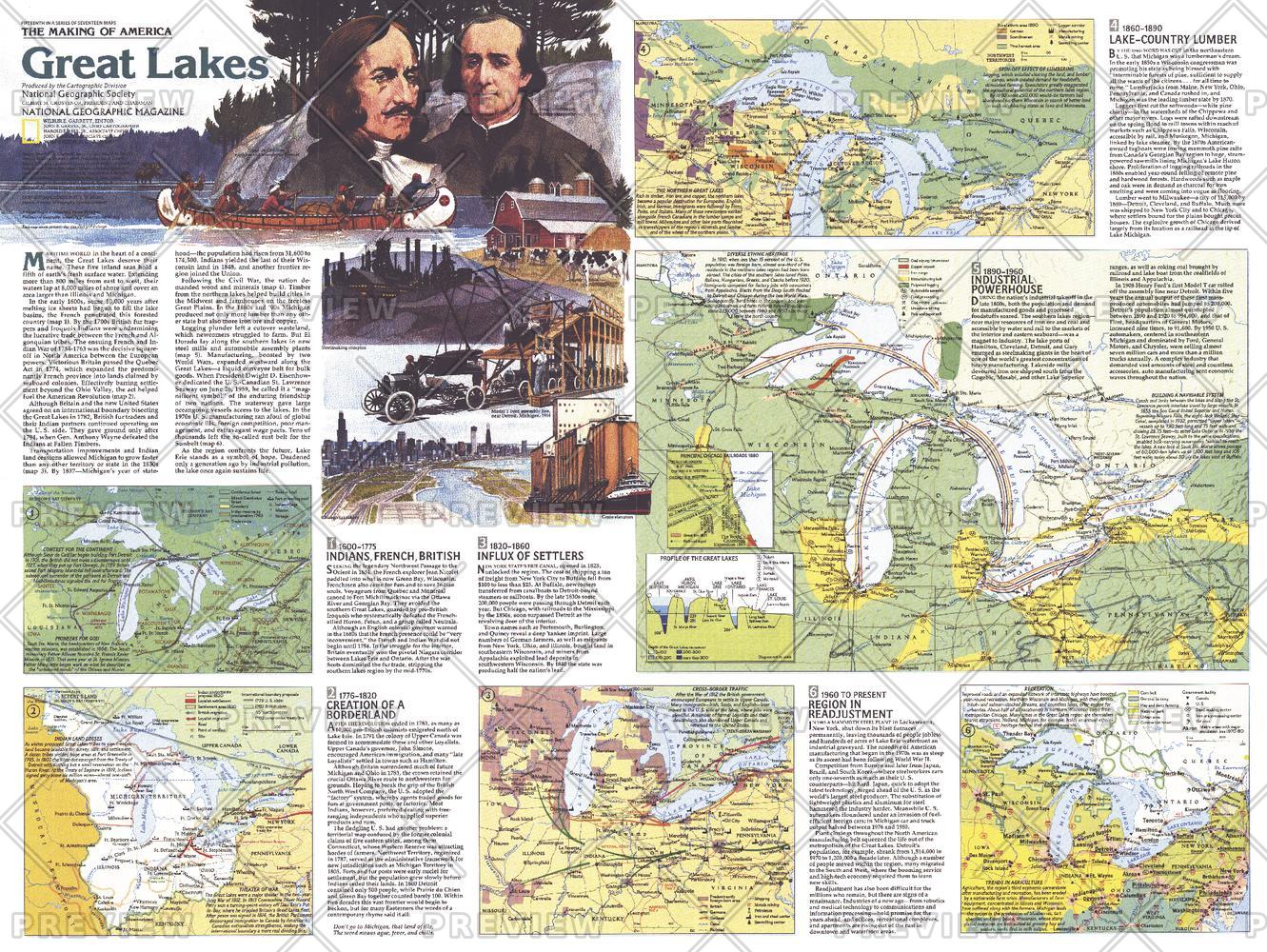
A rich companion to Side 1, Great Lakes — Map Side 2 reveals the human story behind North America’s inland seas. Published by National Geographic in July 1987 as part of the Making of America series, this map explores how the Great Lakes region became a powerhouse of trade, migration, agriculture, and industry.
From early exploration and the fur trade to the rise of modern manufacturing, it presents a layered narrative of a region shaped as much by people as by water.
Why This Map Stands Out
A maritime world inland
Shows how the Great Lakes function as a vast internal waterway system.
A story of development and movement
Traces trade routes, migration patterns, and industrial growth.
Part of the “Making of America” series
Places the region within the broader story of North American expansion.
Historically rich and educational
Connects geography with economic and cultural transformation.
A compelling companion piece
Designed to pair with Great Lakes — Map Side 1 for a complete regional view.
🗺️ What the Map Shows
- The Great Lakes region as a hub of trade and transportation
- Early economic activity including the fur trade and exploration routes
- Growth of agriculture across surrounding fertile lands
- Development of major industrial centres, including Detroit
- Shipping routes and waterways linking inland regions to global trade
- Cultural and historical context shaping settlement patterns
- A regional framework showing the evolution of industry, migration, and commerce
📐 Size & Format
687 mm (W) × 516 mm (H)
Landscape orientation
A balanced format ideal for:
- Classrooms and history departments
- Home offices and studies
- Libraries and regional displays
- Interiors inspired by North American heritage
✨ Premium Finishes
| Format | Description |
|---|---|
| 📜 Paper (160 gsm) | Heavyweight matte-coated paper—ideal for framing. Preserves crisp detail and clarity. |
| 🧼 Laminated (Encapsulated) | Sealed in 2 × 80-micron gloss laminate. Durable, wipe-clean, and suitable for frequent reference. |
| 🪵 Laminated + Timber Hang Rails | Laminated map mounted with lacquered natural timber rails and hanging cord—ready to display. |
| 🖼️ Canvas (395 gsm HP Professional Matte) | Printed with archival pigment inks. Rich texture enhances depth and presentation. |
| 🪵 Canvas + Timber Hang Rails | Canvas paired with timber rails for a refined, gallery-style display. |
🔨 Please allow up to 10 working days for professionally mounted hang-railed finishes.
📊 Specifications
| Feature | Detail |
|---|---|
| Title | Great Lakes — Map Side 2 |
| Publisher | National Geographic |
| Published | 1987 |
| Dimensions | 687 mm × 516 mm |
| Orientation | Landscape |
| Map Type | Historical / Cultural |
| Series | Making of America |
| Coverage | Great Lakes region, North America |
| Collections | North America, Historical |
| Materials | 160 gsm matte paper / 2 × 80-micron laminate / 395 gsm HP Professional Matte Canvas |
| Printing | Pigment-based, fade-resistant inks |
| Origin | Printed in Australia |
🎯 Ideal For
- Students and educators of North American history and geography
- Enthusiasts of the Great Lakes region and its heritage
- Collectors of National Geographic historical maps
- Interiors seeking a story-rich, educational display
- Gift buyers looking for a meaningful regional map
⚓ Where Water Built an Economy
The Great Lakes are more than geography—they are a story of human endeavour:
- Trade routes linking inland regions to global markets
- Waves of migration shaping cities and communities
- Agricultural lands feeding growing populations
- Industrial centres driving economic transformation
This map captures that evolution—revealing a region where waterways became lifelines of commerce and culture.
🤝 Our Commitment
- Printed in Australia using archival-quality production
- Faithfully reproduced to preserve clarity and historical detail
- Premium materials selected for durability and long-term display
- Each map is hand-checked before dispatch
- Carefully packaged for safe delivery
🚚 Delivery
- Paper, Laminated, Canvas (rolled): Dispatch within 1–2 business days
- Hang-Railed Maps: Made to order—allow up to 10 working days
- Packaging: Securely rolled in protective tubing
Discover the story behind North America’s inland seas—
a map that brings the Great Lakes’ history, industry, and movement to life.
👉 Order now and complete the Great Lakes set.
Original: $57.20
-65%$57.20
$20.02Product Information
Product Information
Shipping & Returns
Shipping & Returns
Description
Historical & Cultural Map | Trade, Industry & Migration | Large Wall Format (687 × 516 mm) | Premium Finishes
A rich companion to Side 1, Great Lakes — Map Side 2 reveals the human story behind North America’s inland seas. Published by National Geographic in July 1987 as part of the Making of America series, this map explores how the Great Lakes region became a powerhouse of trade, migration, agriculture, and industry.
From early exploration and the fur trade to the rise of modern manufacturing, it presents a layered narrative of a region shaped as much by people as by water.
Why This Map Stands Out
A maritime world inland
Shows how the Great Lakes function as a vast internal waterway system.
A story of development and movement
Traces trade routes, migration patterns, and industrial growth.
Part of the “Making of America” series
Places the region within the broader story of North American expansion.
Historically rich and educational
Connects geography with economic and cultural transformation.
A compelling companion piece
Designed to pair with Great Lakes — Map Side 1 for a complete regional view.
🗺️ What the Map Shows
- The Great Lakes region as a hub of trade and transportation
- Early economic activity including the fur trade and exploration routes
- Growth of agriculture across surrounding fertile lands
- Development of major industrial centres, including Detroit
- Shipping routes and waterways linking inland regions to global trade
- Cultural and historical context shaping settlement patterns
- A regional framework showing the evolution of industry, migration, and commerce
📐 Size & Format
687 mm (W) × 516 mm (H)
Landscape orientation
A balanced format ideal for:
- Classrooms and history departments
- Home offices and studies
- Libraries and regional displays
- Interiors inspired by North American heritage
✨ Premium Finishes
| Format | Description |
|---|---|
| 📜 Paper (160 gsm) | Heavyweight matte-coated paper—ideal for framing. Preserves crisp detail and clarity. |
| 🧼 Laminated (Encapsulated) | Sealed in 2 × 80-micron gloss laminate. Durable, wipe-clean, and suitable for frequent reference. |
| 🪵 Laminated + Timber Hang Rails | Laminated map mounted with lacquered natural timber rails and hanging cord—ready to display. |
| 🖼️ Canvas (395 gsm HP Professional Matte) | Printed with archival pigment inks. Rich texture enhances depth and presentation. |
| 🪵 Canvas + Timber Hang Rails | Canvas paired with timber rails for a refined, gallery-style display. |
🔨 Please allow up to 10 working days for professionally mounted hang-railed finishes.
📊 Specifications
| Feature | Detail |
|---|---|
| Title | Great Lakes — Map Side 2 |
| Publisher | National Geographic |
| Published | 1987 |
| Dimensions | 687 mm × 516 mm |
| Orientation | Landscape |
| Map Type | Historical / Cultural |
| Series | Making of America |
| Coverage | Great Lakes region, North America |
| Collections | North America, Historical |
| Materials | 160 gsm matte paper / 2 × 80-micron laminate / 395 gsm HP Professional Matte Canvas |
| Printing | Pigment-based, fade-resistant inks |
| Origin | Printed in Australia |
🎯 Ideal For
- Students and educators of North American history and geography
- Enthusiasts of the Great Lakes region and its heritage
- Collectors of National Geographic historical maps
- Interiors seeking a story-rich, educational display
- Gift buyers looking for a meaningful regional map
⚓ Where Water Built an Economy
The Great Lakes are more than geography—they are a story of human endeavour:
- Trade routes linking inland regions to global markets
- Waves of migration shaping cities and communities
- Agricultural lands feeding growing populations
- Industrial centres driving economic transformation
This map captures that evolution—revealing a region where waterways became lifelines of commerce and culture.
🤝 Our Commitment
- Printed in Australia using archival-quality production
- Faithfully reproduced to preserve clarity and historical detail
- Premium materials selected for durability and long-term display
- Each map is hand-checked before dispatch
- Carefully packaged for safe delivery
🚚 Delivery
- Paper, Laminated, Canvas (rolled): Dispatch within 1–2 business days
- Hang-Railed Maps: Made to order—allow up to 10 working days
- Packaging: Securely rolled in protective tubing
Discover the story behind North America’s inland seas—
a map that brings the Great Lakes’ history, industry, and movement to life.
👉 Order now and complete the Great Lakes set.


