Hawai’i - Atlas of the World, 10th Edition by National Geographic
Political Wall Map | Atlas of the World, 10th Edition (Plate 46) | Large Format (711 × 559 mm) | Premium Finishes
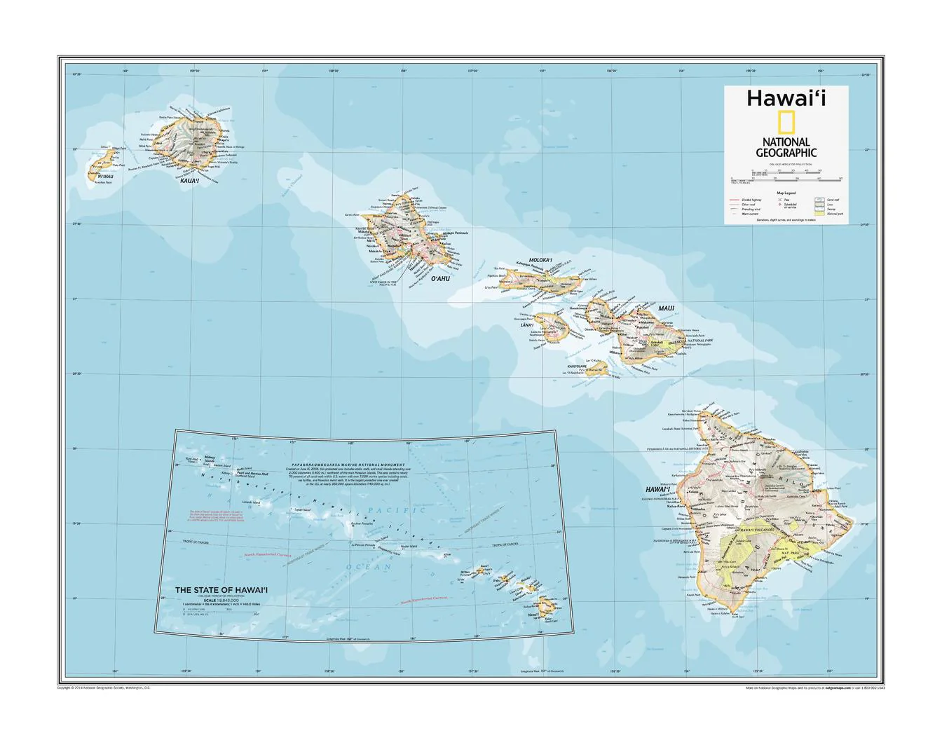
A clear and beautifully balanced view of the Pacific’s most iconic island chain, Hawai‘i presents the state with the precision and clarity expected from National Geographic. Drawn from the Atlas of the World, 10th Edition, this map offers a refined political overview of the islands—combining geographic accuracy with clean, highly readable design.
From major islands to key settlements, it provides a concise yet comprehensive reference to one of the United States’ most distinctive regions.
Why This Map Stands Out
Atlas-quality cartography
Derived from National Geographic’s flagship atlas—accurate, authoritative, and elegant.
Clear political focus
Highlights boundaries, cities, and settlements across the Hawaiian Islands.
Exceptional readability
Carefully placed labels and balanced design ensure easy interpretation.
Compact yet comprehensive
Delivers a complete view of the island chain in a practical format.
A versatile wall map
Ideal for both reference and display.
🗺️ What the Map Shows
- The full extent of Hawaii and its island chain
- Major islands including Oahu, Maui, Hawaii (Big Island), and Kauai
- Cities, towns, and key settlements across the islands
- Political boundaries and regional divisions
- Geographic relationships within the central Pacific
- A clear overview of the state’s layout and structure
📐 Size & Format
711 mm (W) × 559 mm (H)
Landscape orientation
A balanced format ideal for:
- Classrooms and educational settings
- Offices and travel planning environments
- Home studies and workspaces
- Interiors inspired by island geography and the Pacific
✨ Premium Finishes
| Format | Description |
|---|---|
| 📜 Paper (160 gsm) | Heavyweight matte-coated paper—ideal for framing. Preserves clarity and fine detail. |
| 🧼 Laminated (Encapsulated) | Sealed in 2 × 80-micron gloss laminate. Durable, wipe-clean, and suitable for frequent reference. |
| 🪵 Laminated + Timber Hang Rails | Laminated map mounted with lacquered natural timber rails and hanging cord—ready to display. |
| 🖼️ Canvas (395 gsm HP Professional Matte) | Printed with archival pigment inks. Enhances depth and presentation. |
| 🪵 Canvas + Timber Hang Rails | Canvas paired with timber rails for a refined, gallery-style display. |
🔨 Please allow up to 10 working days for professionally mounted hang-railed finishes.
📊 Specifications
| Feature | Detail |
|---|---|
| Title | Hawai‘i |
| Publisher | National Geographic |
| Published | 25 February 2015 |
| Source | Atlas of the World, 10th Edition (Plate 46) |
| Dimensions | 711 mm × 559 mm |
| Orientation | Landscape |
| Map Type | Political |
| Coverage | Hawaiian Islands, USA |
| Collections | USA |
| Materials | 160 gsm matte paper / 2 × 80-micron laminate / 395 gsm HP Professional Matte Canvas |
| Printing | Pigment-based, fade-resistant inks |
| Origin | Printed in Australia |
🎯 Ideal For
- Students and educators of geography and Pacific regions
- Travellers planning trips to Hawai‘i
- Collectors of National Geographic atlas maps
- Interiors seeking a clean, island-themed display
- Gift buyers looking for a practical and attractive map
🌊 An Island Chain in the Pacific
Hawai‘i is defined by its setting:
- A remote archipelago in the vast Pacific Ocean
- Islands shaped by volcanic origins and ocean forces
- Communities connected across water and distance
- A unique blend of geography, culture, and identity
This map captures that structure—offering a clear and elegant view of one of the world’s most recognisable island regions.
🤝 Our Commitment
- Printed in Australia using archival-quality production
- Faithfully reproduced to preserve clarity and detail
- Premium materials selected for durability and long-term display
- Each map is hand-checked before dispatch
- Carefully packaged for safe delivery
🚚 Delivery
- Paper, Laminated, Canvas (rolled): Dispatch within 1–2 business days
- Hang-Railed Maps: Made to order—allow up to 10 working days
- Packaging: Securely rolled in protective tubing
Explore the Pacific’s most iconic island chain—
a map that brings Hawai‘i into clear, elegant focus.
👉 Order now and add a beautiful island perspective to your wall.
Original: $50.05
-65%$50.05
$17.52Product Information
Product Information
Shipping & Returns
Shipping & Returns
Description
Political Wall Map | Atlas of the World, 10th Edition (Plate 46) | Large Format (711 × 559 mm) | Premium Finishes
A clear and beautifully balanced view of the Pacific’s most iconic island chain, Hawai‘i presents the state with the precision and clarity expected from National Geographic. Drawn from the Atlas of the World, 10th Edition, this map offers a refined political overview of the islands—combining geographic accuracy with clean, highly readable design.
From major islands to key settlements, it provides a concise yet comprehensive reference to one of the United States’ most distinctive regions.
Why This Map Stands Out
Atlas-quality cartography
Derived from National Geographic’s flagship atlas—accurate, authoritative, and elegant.
Clear political focus
Highlights boundaries, cities, and settlements across the Hawaiian Islands.
Exceptional readability
Carefully placed labels and balanced design ensure easy interpretation.
Compact yet comprehensive
Delivers a complete view of the island chain in a practical format.
A versatile wall map
Ideal for both reference and display.
🗺️ What the Map Shows
- The full extent of Hawaii and its island chain
- Major islands including Oahu, Maui, Hawaii (Big Island), and Kauai
- Cities, towns, and key settlements across the islands
- Political boundaries and regional divisions
- Geographic relationships within the central Pacific
- A clear overview of the state’s layout and structure
📐 Size & Format
711 mm (W) × 559 mm (H)
Landscape orientation
A balanced format ideal for:
- Classrooms and educational settings
- Offices and travel planning environments
- Home studies and workspaces
- Interiors inspired by island geography and the Pacific
✨ Premium Finishes
| Format | Description |
|---|---|
| 📜 Paper (160 gsm) | Heavyweight matte-coated paper—ideal for framing. Preserves clarity and fine detail. |
| 🧼 Laminated (Encapsulated) | Sealed in 2 × 80-micron gloss laminate. Durable, wipe-clean, and suitable for frequent reference. |
| 🪵 Laminated + Timber Hang Rails | Laminated map mounted with lacquered natural timber rails and hanging cord—ready to display. |
| 🖼️ Canvas (395 gsm HP Professional Matte) | Printed with archival pigment inks. Enhances depth and presentation. |
| 🪵 Canvas + Timber Hang Rails | Canvas paired with timber rails for a refined, gallery-style display. |
🔨 Please allow up to 10 working days for professionally mounted hang-railed finishes.
📊 Specifications
| Feature | Detail |
|---|---|
| Title | Hawai‘i |
| Publisher | National Geographic |
| Published | 25 February 2015 |
| Source | Atlas of the World, 10th Edition (Plate 46) |
| Dimensions | 711 mm × 559 mm |
| Orientation | Landscape |
| Map Type | Political |
| Coverage | Hawaiian Islands, USA |
| Collections | USA |
| Materials | 160 gsm matte paper / 2 × 80-micron laminate / 395 gsm HP Professional Matte Canvas |
| Printing | Pigment-based, fade-resistant inks |
| Origin | Printed in Australia |
🎯 Ideal For
- Students and educators of geography and Pacific regions
- Travellers planning trips to Hawai‘i
- Collectors of National Geographic atlas maps
- Interiors seeking a clean, island-themed display
- Gift buyers looking for a practical and attractive map
🌊 An Island Chain in the Pacific
Hawai‘i is defined by its setting:
- A remote archipelago in the vast Pacific Ocean
- Islands shaped by volcanic origins and ocean forces
- Communities connected across water and distance
- A unique blend of geography, culture, and identity
This map captures that structure—offering a clear and elegant view of one of the world’s most recognisable island regions.
🤝 Our Commitment
- Printed in Australia using archival-quality production
- Faithfully reproduced to preserve clarity and detail
- Premium materials selected for durability and long-term display
- Each map is hand-checked before dispatch
- Carefully packaged for safe delivery
🚚 Delivery
- Paper, Laminated, Canvas (rolled): Dispatch within 1–2 business days
- Hang-Railed Maps: Made to order—allow up to 10 working days
- Packaging: Securely rolled in protective tubing
Explore the Pacific’s most iconic island chain—
a map that brings Hawai‘i into clear, elegant focus.
👉 Order now and add a beautiful island perspective to your wall.


