Hawaiian Islands Wall Map by Franko
Hawaiian Islands Wall Map — Franko’s Maps (2024) — 914 × 610 mm
Island Chain Overview | Shaded Relief | Hypsometric Tinting | Reef Life Illustrations | Premium Finishes
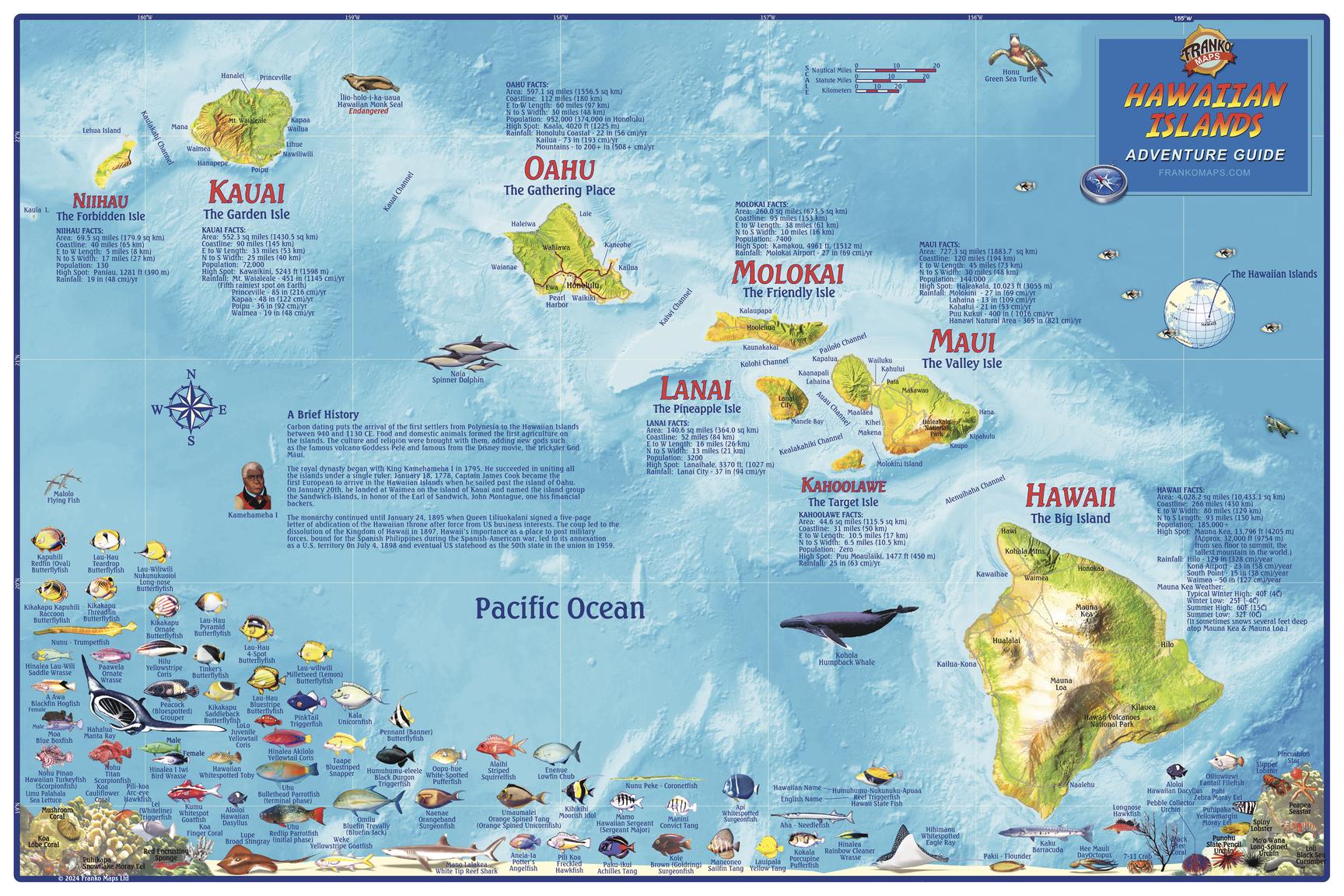
Take in the full sweep of the Hawaiian archipelago with this vibrant, information-rich wall map by Franko’s Maps. Depicting the entire island chain in colourful shaded relief, the map uses hypsometric tinting to clearly visualise land elevations and surrounding ocean depths—revealing volcanic origins, island spacing, and underwater shelves at a glance. Dozens of Hawaiʻi’s exotic reef fish and marine creatures are beautifully illustrated throughout, while facts and statistics for each island add depth, context, and educational value. The result is a map that works equally well as a reference, teaching aid, and striking coastal statement piece.
🗺️ Highlights at a Glance
-
Whole archipelago view — All major Hawaiian Islands shown together in clear geographic context
-
Shaded relief — Terrain and volcanic forms rendered with dramatic depth
-
Hypsometric colour — Land heights and water depths visualised through intuitive colour gradients
-
Marine life illustrated — Dozens of tropical fish and reef creatures vividly depicted
-
Island facts & stats — Key information panels for each island
-
Wall-ready clarity — Designed for legibility, colour balance, and impact at statement scale
Wall/reference use only. Always consult current local guidance when recreating or studying marine environments.
✨ Premium Finishes
Every Hawaiian Islands Wall Map is printed in Australia using archival methods to preserve colour vibrancy, fine illustration detail, and long-term durability. Select the finish that best suits your space and intended use.
| Format | Description |
|---|---|
| 📜 Paper (160 gsm matte) | Smooth, heavyweight archival stock with excellent colour fidelity. Ideal for framing under glass and a classic gallery-style presentation. |
| 🧼 Laminated (True Encapsulation) | Fully sealed between 2 × 80-micron gloss laminate, edge-to-edge. Tear-resistant, wipe-clean, and highly durable—perfect for planning, classrooms, and frequent reference. |
| 🖼️ Canvas (395 gsm HP Professional Matte) | Printed on premium HP 395 gsm Professional Matte Canvas using pigment-based, fade-resistant inks. Adds warmth and texture to shaded relief and marine illustrations—ideal as a statement piece. |
| 🪵 Laminated + Timber Hang Rails | Laminated map fitted with natural timber hang rails (top & bottom) and a discreet hanging cord. Ready to hang with no framing required. Please allow up to 10 working days for mounting. |
| 🪵 Canvas + Timber Hang Rails | Canvas finished with lacquered natural timber rails for a clean, frameless presentation. Simply hang from a single wall hook. Please allow up to 10 working days for completion. |
📐 Specifications
| Feature | Detail |
|---|---|
| Title | Hawaiian Islands Wall Map — Franko’s Maps |
| Edition / Year | 2024 |
| Coverage | Entire Hawaiian Island chain |
| Map Type | Shaded-relief recreation & educational reference map |
| Content | Hypsometric elevation & depth tinting, reef fish illustrations, island facts & statistics |
| Dimensions | 914 mm (W) × 610 mm (H) |
| Finishes | Paper, Laminated (2×80-micron), Canvas (395 gsm), optional timber hang rails |
| Printing | Archival pigment inks for long-term colour stability |
| Origin | Printed in Australia |
🎯 Ideal For
-
Hawaiʻi lovers wanting the entire island chain in one elegant view
-
Marine-life enthusiasts and reef-fish fans
-
Educators, classrooms, and learning spaces
-
Homes, offices, clubs, and coastal interiors seeking a vibrant Pacific centrepiece
🤝 Our Commitment
-
Local craftsmanship — Printed and finished in Australia
-
Premium materials — Archival pigment inks, professional laminates, natural timber rails
-
Colour-managed clarity — Balanced tones and crisp labelling at wall scale
-
Built to last — Durable finishes designed for years of enjoyment
-
Packed with care — Hand-checked and shipped display-ready
🚚 Shipping & Lead Time
-
Paper / Laminated / Canvas (rolled): Usually ships within 1–2 business days
-
Hang-railed maps: Custom mounted—please allow up to 10 working days
Celebrate Hawaiʻi as a connected island world—above and below the waterline. Add to cart and let the Hawaiian Islands unfold across your wall.
Original: $50.05
-65%$50.05
$17.52Product Information
Product Information
Shipping & Returns
Shipping & Returns
Description
Hawaiian Islands Wall Map — Franko’s Maps (2024) — 914 × 610 mm
Island Chain Overview | Shaded Relief | Hypsometric Tinting | Reef Life Illustrations | Premium Finishes
Take in the full sweep of the Hawaiian archipelago with this vibrant, information-rich wall map by Franko’s Maps. Depicting the entire island chain in colourful shaded relief, the map uses hypsometric tinting to clearly visualise land elevations and surrounding ocean depths—revealing volcanic origins, island spacing, and underwater shelves at a glance. Dozens of Hawaiʻi’s exotic reef fish and marine creatures are beautifully illustrated throughout, while facts and statistics for each island add depth, context, and educational value. The result is a map that works equally well as a reference, teaching aid, and striking coastal statement piece.
🗺️ Highlights at a Glance
-
Whole archipelago view — All major Hawaiian Islands shown together in clear geographic context
-
Shaded relief — Terrain and volcanic forms rendered with dramatic depth
-
Hypsometric colour — Land heights and water depths visualised through intuitive colour gradients
-
Marine life illustrated — Dozens of tropical fish and reef creatures vividly depicted
-
Island facts & stats — Key information panels for each island
-
Wall-ready clarity — Designed for legibility, colour balance, and impact at statement scale
Wall/reference use only. Always consult current local guidance when recreating or studying marine environments.
✨ Premium Finishes
Every Hawaiian Islands Wall Map is printed in Australia using archival methods to preserve colour vibrancy, fine illustration detail, and long-term durability. Select the finish that best suits your space and intended use.
| Format | Description |
|---|---|
| 📜 Paper (160 gsm matte) | Smooth, heavyweight archival stock with excellent colour fidelity. Ideal for framing under glass and a classic gallery-style presentation. |
| 🧼 Laminated (True Encapsulation) | Fully sealed between 2 × 80-micron gloss laminate, edge-to-edge. Tear-resistant, wipe-clean, and highly durable—perfect for planning, classrooms, and frequent reference. |
| 🖼️ Canvas (395 gsm HP Professional Matte) | Printed on premium HP 395 gsm Professional Matte Canvas using pigment-based, fade-resistant inks. Adds warmth and texture to shaded relief and marine illustrations—ideal as a statement piece. |
| 🪵 Laminated + Timber Hang Rails | Laminated map fitted with natural timber hang rails (top & bottom) and a discreet hanging cord. Ready to hang with no framing required. Please allow up to 10 working days for mounting. |
| 🪵 Canvas + Timber Hang Rails | Canvas finished with lacquered natural timber rails for a clean, frameless presentation. Simply hang from a single wall hook. Please allow up to 10 working days for completion. |
📐 Specifications
| Feature | Detail |
|---|---|
| Title | Hawaiian Islands Wall Map — Franko’s Maps |
| Edition / Year | 2024 |
| Coverage | Entire Hawaiian Island chain |
| Map Type | Shaded-relief recreation & educational reference map |
| Content | Hypsometric elevation & depth tinting, reef fish illustrations, island facts & statistics |
| Dimensions | 914 mm (W) × 610 mm (H) |
| Finishes | Paper, Laminated (2×80-micron), Canvas (395 gsm), optional timber hang rails |
| Printing | Archival pigment inks for long-term colour stability |
| Origin | Printed in Australia |
🎯 Ideal For
-
Hawaiʻi lovers wanting the entire island chain in one elegant view
-
Marine-life enthusiasts and reef-fish fans
-
Educators, classrooms, and learning spaces
-
Homes, offices, clubs, and coastal interiors seeking a vibrant Pacific centrepiece
🤝 Our Commitment
-
Local craftsmanship — Printed and finished in Australia
-
Premium materials — Archival pigment inks, professional laminates, natural timber rails
-
Colour-managed clarity — Balanced tones and crisp labelling at wall scale
-
Built to last — Durable finishes designed for years of enjoyment
-
Packed with care — Hand-checked and shipped display-ready
🚚 Shipping & Lead Time
-
Paper / Laminated / Canvas (rolled): Usually ships within 1–2 business days
-
Hang-railed maps: Custom mounted—please allow up to 10 working days
Celebrate Hawaiʻi as a connected island world—above and below the waterline. Add to cart and let the Hawaiian Islands unfold across your wall.