Heart of the Grand Canyon - Published 1999 by National Geographic
Topographic Wall Map | Trails, Terrain & Park Detail | Large Format (888 × 913 mm) | Premium Finishes
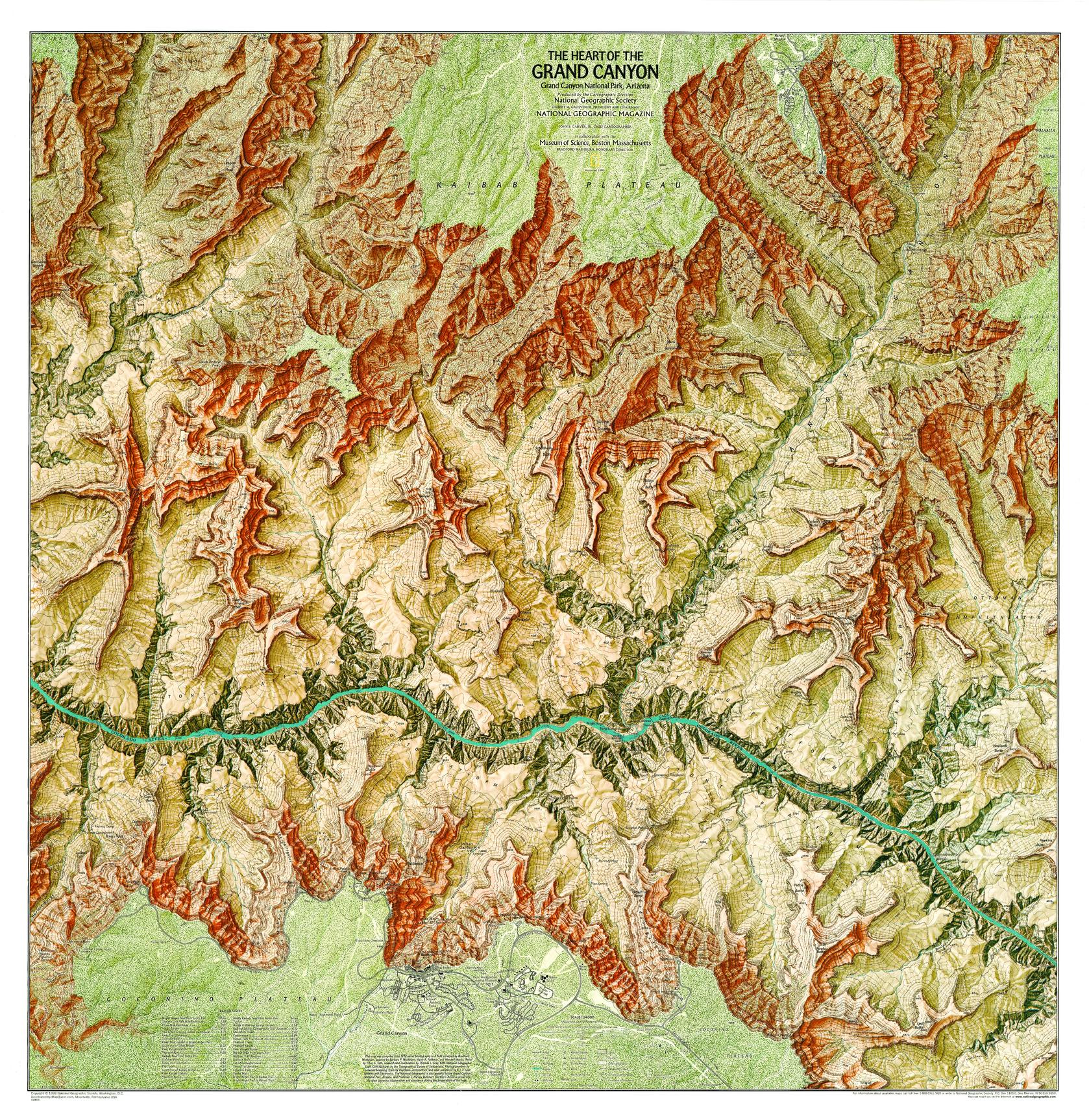
A beautifully detailed map that brings the inner canyon into sharp focus, Heart of the Grand Canyon captures the rugged complexity of one of the world’s most iconic landscapes. Published by National Geographic in 1999, this large-format map combines precise topographic detail with practical information for exploring Grand Canyon National Park.
From steep canyon walls to winding river corridors, it’s both a serious planning tool and a striking visual representation of the canyon’s scale and structure.
Why This Map Stands Out
High-resolution topographic detail
Contours and shading reveal the canyon’s dramatic depth and terrain.
Built for exploration
Includes trails, campgrounds, and park facilities for real-world planning.
Large-scale clarity (1:24,000)
Exceptional level of detail—ideal for hikers, trekkers, and researchers.
National Geographic authority
Trusted cartography with clear, balanced design.
A commanding wall map
Near-square format creates a bold and immersive display.
🗺️ What the Map Shows
- Detailed topography of the central Grand Canyon region
- The course of the Colorado River through the canyon
- Major and minor hiking trails and backcountry routes
- Locations of campgrounds, ranger stations, and park facilities
- Elevation contours showing the canyon’s depth and structure
- Key landmarks and points of interest within the canyon
📐 Size & Format
888 mm (W) × 913 mm (H)
Portrait orientation
A large, highly detailed format ideal for:
- Trip planning and route visualisation
- Classrooms and geography departments
- Home offices and study spaces
- Feature walls celebrating natural landscapes
✨ Premium Finishes
| Format | Description |
|---|---|
| 📜 Paper (160 gsm) | Heavyweight matte-coated paper—ideal for framing. Preserves fine topographic detail. |
| 🧼 Laminated (Encapsulated) | Sealed in 2 × 80-micron gloss laminate. Durable, wipe-clean, and perfect for planning use. |
| 🪵 Laminated + Timber Hang Rails | Laminated map mounted with lacquered natural timber rails and hanging cord—ready to display. |
| 🖼️ Canvas (395 gsm HP Professional Matte) | Printed with archival pigment inks. Rich texture enhances terrain depth and visual impact. |
| 🪵 Canvas + Timber Hang Rails | Canvas paired with timber rails for a refined, gallery-style presentation. |
🔨 Please allow up to 10 working days for professionally mounted hang-railed finishes.
📊 Specifications
| Feature | Detail |
|---|---|
| Title | Heart of the Grand Canyon |
| Publisher | National Geographic |
| Published | 1999 |
| Scale | 1:24,000 |
| Dimensions | 888 mm × 913 mm |
| Orientation | Portrait |
| Map Type | Topographic / Recreational |
| Coverage | Grand Canyon, Arizona, USA |
| Collections | USA, Historical, Topographic |
| Materials | 160 gsm matte paper / 2 × 80-micron laminate / 395 gsm HP Professional Matte Canvas |
| Printing | Pigment-based, fade-resistant inks |
| Origin | Printed in Australia |
🎯 Ideal For
- Hikers and adventurers planning Grand Canyon expeditions
- Students and educators of geography and earth science
- Collectors of National Geographic topographic maps
- Interiors inspired by iconic natural landscapes
- Gift buyers seeking a practical and visually striking map
🏜️ Into the Depths of the Canyon
The Grand Canyon is a landscape of immense scale:
- Sheer cliffs and layered rock formations
- Trails descending from rim to river
- The Colorado River carving its ancient path
- A terrain that is both beautiful and demanding
This map captures that experience—offering a detailed view of a place where distance, elevation, and time converge.
🤝 Our Commitment
- Printed in Australia using archival-quality production
- Faithfully reproduced to preserve topographic clarity and detail
- Premium materials selected for durability and long-term display
- Each map is hand-checked before dispatch
- Carefully packaged for safe delivery
🚚 Delivery
- Paper, Laminated, Canvas (rolled): Dispatch within 1–2 business days
- Hang-Railed Maps: Made to order—allow up to 10 working days
- Packaging: Securely rolled in protective tubing
Explore the canyon from rim to river—
a map that brings the heart of the Grand Canyon into vivid detail.
👉 Order now and plan your journey into one of the world’s greatest landscapes.
Original: $57.20
-65%$57.20
$20.02Product Information
Product Information
Shipping & Returns
Shipping & Returns
Description
Topographic Wall Map | Trails, Terrain & Park Detail | Large Format (888 × 913 mm) | Premium Finishes
A beautifully detailed map that brings the inner canyon into sharp focus, Heart of the Grand Canyon captures the rugged complexity of one of the world’s most iconic landscapes. Published by National Geographic in 1999, this large-format map combines precise topographic detail with practical information for exploring Grand Canyon National Park.
From steep canyon walls to winding river corridors, it’s both a serious planning tool and a striking visual representation of the canyon’s scale and structure.
Why This Map Stands Out
High-resolution topographic detail
Contours and shading reveal the canyon’s dramatic depth and terrain.
Built for exploration
Includes trails, campgrounds, and park facilities for real-world planning.
Large-scale clarity (1:24,000)
Exceptional level of detail—ideal for hikers, trekkers, and researchers.
National Geographic authority
Trusted cartography with clear, balanced design.
A commanding wall map
Near-square format creates a bold and immersive display.
🗺️ What the Map Shows
- Detailed topography of the central Grand Canyon region
- The course of the Colorado River through the canyon
- Major and minor hiking trails and backcountry routes
- Locations of campgrounds, ranger stations, and park facilities
- Elevation contours showing the canyon’s depth and structure
- Key landmarks and points of interest within the canyon
📐 Size & Format
888 mm (W) × 913 mm (H)
Portrait orientation
A large, highly detailed format ideal for:
- Trip planning and route visualisation
- Classrooms and geography departments
- Home offices and study spaces
- Feature walls celebrating natural landscapes
✨ Premium Finishes
| Format | Description |
|---|---|
| 📜 Paper (160 gsm) | Heavyweight matte-coated paper—ideal for framing. Preserves fine topographic detail. |
| 🧼 Laminated (Encapsulated) | Sealed in 2 × 80-micron gloss laminate. Durable, wipe-clean, and perfect for planning use. |
| 🪵 Laminated + Timber Hang Rails | Laminated map mounted with lacquered natural timber rails and hanging cord—ready to display. |
| 🖼️ Canvas (395 gsm HP Professional Matte) | Printed with archival pigment inks. Rich texture enhances terrain depth and visual impact. |
| 🪵 Canvas + Timber Hang Rails | Canvas paired with timber rails for a refined, gallery-style presentation. |
🔨 Please allow up to 10 working days for professionally mounted hang-railed finishes.
📊 Specifications
| Feature | Detail |
|---|---|
| Title | Heart of the Grand Canyon |
| Publisher | National Geographic |
| Published | 1999 |
| Scale | 1:24,000 |
| Dimensions | 888 mm × 913 mm |
| Orientation | Portrait |
| Map Type | Topographic / Recreational |
| Coverage | Grand Canyon, Arizona, USA |
| Collections | USA, Historical, Topographic |
| Materials | 160 gsm matte paper / 2 × 80-micron laminate / 395 gsm HP Professional Matte Canvas |
| Printing | Pigment-based, fade-resistant inks |
| Origin | Printed in Australia |
🎯 Ideal For
- Hikers and adventurers planning Grand Canyon expeditions
- Students and educators of geography and earth science
- Collectors of National Geographic topographic maps
- Interiors inspired by iconic natural landscapes
- Gift buyers seeking a practical and visually striking map
🏜️ Into the Depths of the Canyon
The Grand Canyon is a landscape of immense scale:
- Sheer cliffs and layered rock formations
- Trails descending from rim to river
- The Colorado River carving its ancient path
- A terrain that is both beautiful and demanding
This map captures that experience—offering a detailed view of a place where distance, elevation, and time converge.
🤝 Our Commitment
- Printed in Australia using archival-quality production
- Faithfully reproduced to preserve topographic clarity and detail
- Premium materials selected for durability and long-term display
- Each map is hand-checked before dispatch
- Carefully packaged for safe delivery
🚚 Delivery
- Paper, Laminated, Canvas (rolled): Dispatch within 1–2 business days
- Hang-Railed Maps: Made to order—allow up to 10 working days
- Packaging: Securely rolled in protective tubing
Explore the canyon from rim to river—
a map that brings the heart of the Grand Canyon into vivid detail.
👉 Order now and plan your journey into one of the world’s greatest landscapes.


