Heart of the Middle East - Published 2002 by National Geographic
Political Wall Map | Cities, Borders & Regional Context | Large Format (791 × 511 mm) | Premium Finishes
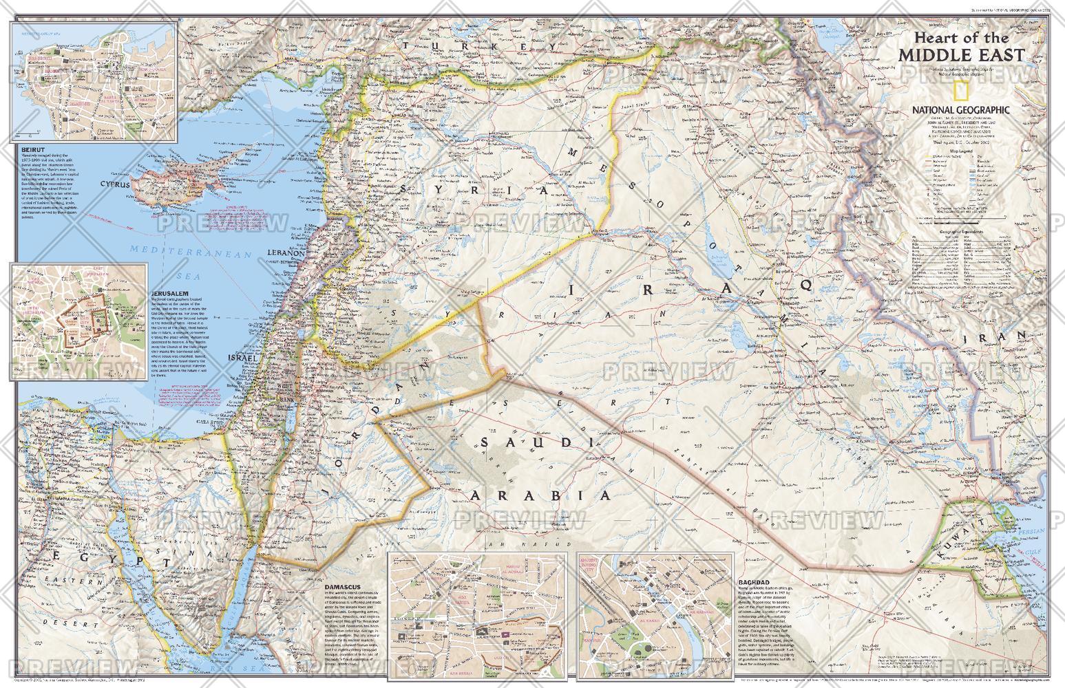
A clear and engaging political overview of one of the world’s most complex regions, Heart of the Middle East presents the core countries and cities that define this historic crossroads. Published by National Geographic in October 2002, this map forms part of a two-piece set alongside Middle East: Crossroads of Faith and Conflict.
Combining regional clarity with detailed city insets, it offers both a broad geopolitical perspective and a closer look at key urban centres.
Why This Map Stands Out
A focused regional perspective
Highlights the central countries shaping the modern Middle East.
Detailed urban insets
Includes close-up maps of major cities for added context and clarity.
Balanced political cartography
Clearly defines borders, capitals, and major population centres.
National Geographic authority
Renowned for accuracy, readability, and refined design.
A versatile educational map
Ideal for both reference and display.
🗺️ What the Map Shows
- Political boundaries across the core Middle East region
- Capitals and major cities throughout the region
- Clear geographic relationships between neighbouring countries
- Detailed inset maps of key cities:
- Beirut
- Jerusalem
- Damascus
- Baghdad
- A regional framework linking Africa and Asia
- A clear view of one of the world’s most historically and politically significant areas
📐 Size & Format
791 mm (W) × 511 mm (H)
Landscape orientation
A balanced format ideal for:
- Classrooms and educational environments
- Offices and policy settings
- Home studies and workspaces
- Interiors focused on global geography and current affairs
✨ Premium Finishes
| Format | Description |
|---|---|
| 📜 Paper (160 gsm) | Heavyweight matte-coated paper—ideal for framing. Preserves crisp detail and clarity. |
| 🧼 Laminated (Encapsulated) | Sealed in 2 × 80-micron gloss laminate. Durable, wipe-clean, and suitable for frequent reference. |
| 🪵 Laminated + Timber Hang Rails | Laminated map mounted with lacquered natural timber rails and hanging cord—ready to display. |
| 🖼️ Canvas (395 gsm HP Professional Matte) | Printed with archival pigment inks. Rich texture enhances depth and presentation. |
| 🪵 Canvas + Timber Hang Rails | Canvas paired with timber rails for a refined, gallery-style display. |
🔨 Please allow up to 10 working days for professionally mounted hang-railed finishes.
📊 Specifications
| Feature | Detail |
|---|---|
| Title | Heart of the Middle East |
| Publisher | National Geographic |
| Published | 2002 |
| Dimensions | 791 mm × 511 mm |
| Orientation | Landscape |
| Map Type | Political |
| Coverage | Middle East (Africa & Asia interface) |
| Collections | Africa, Asia, Historical |
| Materials | 160 gsm matte paper / 2 × 80-micron laminate / 395 gsm HP Professional Matte Canvas |
| Printing | Pigment-based, fade-resistant inks |
| Origin | Printed in Australia |
🎯 Ideal For
- Students and educators of geography and geopolitics
- Professionals needing a clear Middle East reference map
- Collectors of National Geographic regional maps
- Interiors focused on global awareness and current affairs
- Gift buyers seeking a thoughtful and informative map
🌍 A Region at the Crossroads
The Middle East sits at the intersection of continents and history:
- A meeting point of Africa and Asia
- Cities with deep cultural and historical significance
- Borders shaped by centuries of change
- A region where geography and geopolitics are closely intertwined
This map captures that complexity—offering a clear and balanced view of a region that continues to shape the world.
🤝 Our Commitment
- Printed in Australia using archival-quality production
- Faithfully reproduced to preserve clarity and detail
- Premium materials selected for durability and long-term display
- Each map is hand-checked before dispatch
- Carefully packaged for safe delivery
🚚 Delivery
- Paper, Laminated, Canvas (rolled): Dispatch within 1–2 business days
- Hang-Railed Maps: Made to order—allow up to 10 working days
- Packaging: Securely rolled in protective tubing
See the Middle East in clear perspective—
a map that brings geography, cities, and context together.
👉 Order now and add a vital global reference to your wall.
Original: $57.20
-65%$57.20
$20.02Product Information
Product Information
Shipping & Returns
Shipping & Returns
Description
Political Wall Map | Cities, Borders & Regional Context | Large Format (791 × 511 mm) | Premium Finishes
A clear and engaging political overview of one of the world’s most complex regions, Heart of the Middle East presents the core countries and cities that define this historic crossroads. Published by National Geographic in October 2002, this map forms part of a two-piece set alongside Middle East: Crossroads of Faith and Conflict.
Combining regional clarity with detailed city insets, it offers both a broad geopolitical perspective and a closer look at key urban centres.
Why This Map Stands Out
A focused regional perspective
Highlights the central countries shaping the modern Middle East.
Detailed urban insets
Includes close-up maps of major cities for added context and clarity.
Balanced political cartography
Clearly defines borders, capitals, and major population centres.
National Geographic authority
Renowned for accuracy, readability, and refined design.
A versatile educational map
Ideal for both reference and display.
🗺️ What the Map Shows
- Political boundaries across the core Middle East region
- Capitals and major cities throughout the region
- Clear geographic relationships between neighbouring countries
- Detailed inset maps of key cities:
- Beirut
- Jerusalem
- Damascus
- Baghdad
- A regional framework linking Africa and Asia
- A clear view of one of the world’s most historically and politically significant areas
📐 Size & Format
791 mm (W) × 511 mm (H)
Landscape orientation
A balanced format ideal for:
- Classrooms and educational environments
- Offices and policy settings
- Home studies and workspaces
- Interiors focused on global geography and current affairs
✨ Premium Finishes
| Format | Description |
|---|---|
| 📜 Paper (160 gsm) | Heavyweight matte-coated paper—ideal for framing. Preserves crisp detail and clarity. |
| 🧼 Laminated (Encapsulated) | Sealed in 2 × 80-micron gloss laminate. Durable, wipe-clean, and suitable for frequent reference. |
| 🪵 Laminated + Timber Hang Rails | Laminated map mounted with lacquered natural timber rails and hanging cord—ready to display. |
| 🖼️ Canvas (395 gsm HP Professional Matte) | Printed with archival pigment inks. Rich texture enhances depth and presentation. |
| 🪵 Canvas + Timber Hang Rails | Canvas paired with timber rails for a refined, gallery-style display. |
🔨 Please allow up to 10 working days for professionally mounted hang-railed finishes.
📊 Specifications
| Feature | Detail |
|---|---|
| Title | Heart of the Middle East |
| Publisher | National Geographic |
| Published | 2002 |
| Dimensions | 791 mm × 511 mm |
| Orientation | Landscape |
| Map Type | Political |
| Coverage | Middle East (Africa & Asia interface) |
| Collections | Africa, Asia, Historical |
| Materials | 160 gsm matte paper / 2 × 80-micron laminate / 395 gsm HP Professional Matte Canvas |
| Printing | Pigment-based, fade-resistant inks |
| Origin | Printed in Australia |
🎯 Ideal For
- Students and educators of geography and geopolitics
- Professionals needing a clear Middle East reference map
- Collectors of National Geographic regional maps
- Interiors focused on global awareness and current affairs
- Gift buyers seeking a thoughtful and informative map
🌍 A Region at the Crossroads
The Middle East sits at the intersection of continents and history:
- A meeting point of Africa and Asia
- Cities with deep cultural and historical significance
- Borders shaped by centuries of change
- A region where geography and geopolitics are closely intertwined
This map captures that complexity—offering a clear and balanced view of a region that continues to shape the world.
🤝 Our Commitment
- Printed in Australia using archival-quality production
- Faithfully reproduced to preserve clarity and detail
- Premium materials selected for durability and long-term display
- Each map is hand-checked before dispatch
- Carefully packaged for safe delivery
🚚 Delivery
- Paper, Laminated, Canvas (rolled): Dispatch within 1–2 business days
- Hang-Railed Maps: Made to order—allow up to 10 working days
- Packaging: Securely rolled in protective tubing
See the Middle East in clear perspective—
a map that brings geography, cities, and context together.
👉 Order now and add a vital global reference to your wall.


