High Himalaya - Published 1988 by National Geographic
Panoramic Relief Map | Kathmandu to Everest | Large Wall Format (911 × 573 mm) | Premium Finishes
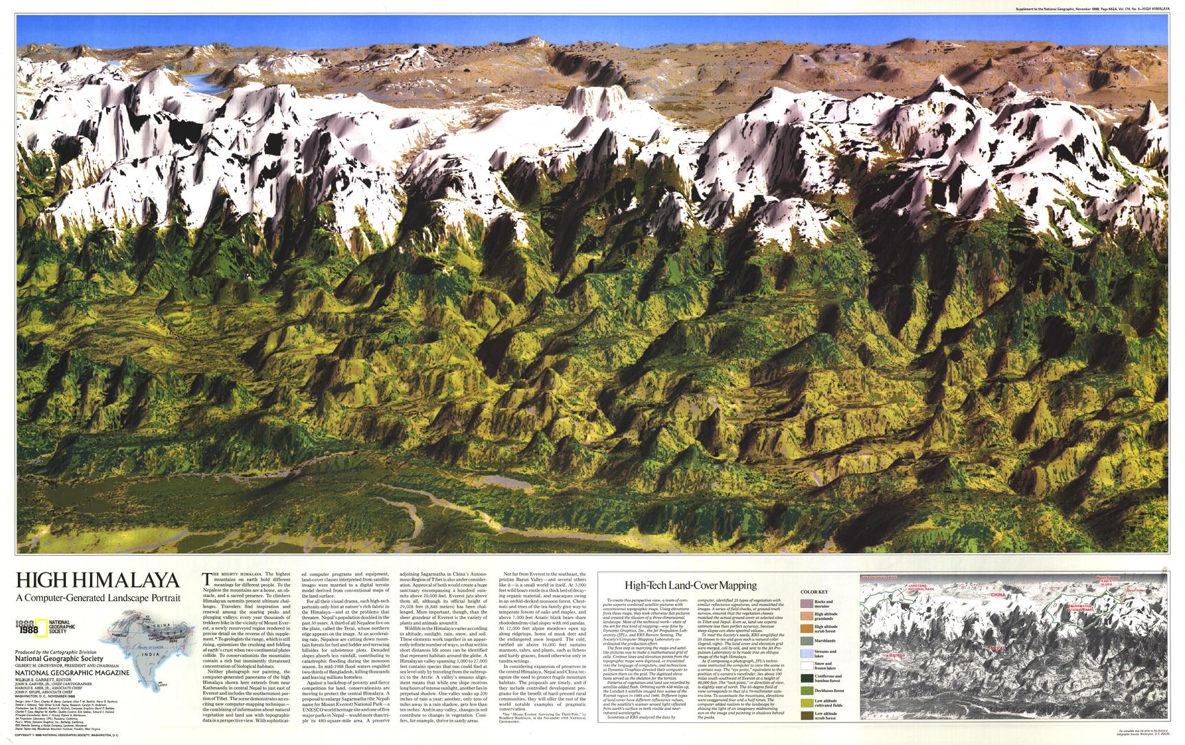
A breathtaking visualisation of the world’s highest mountain range, High Himalaya presents a sweeping, computer-generated panorama that captures the grandeur of the Himalayas in extraordinary detail. Published by National Geographic in November 1988, this remarkable work spans from Kathmandu to just east of Mount Everest—rendering the landscape with a depth and colour that feels both scientific and artistic.
Neither photograph nor painting, this innovative map blends data and design to create a vivid, almost three-dimensional view of one of Earth’s most dramatic regions.
Why This Map Stands Out
A pioneering visualisation
Computer-generated at a time when digital mapping was still emerging—remarkably ahead of its era.
A panoramic Himalayan sweep
Covers the central Himalaya, including the Everest region, in one continuous view.
Striking relief and depth
Captures the immense vertical scale of the mountains with exceptional clarity.
Part of a National Geographic feature set
Published alongside a companion Everest map and in-depth articles.
A true statement piece
Combines scientific precision with visual drama—ideal for display.
🗺️ What the Map Shows
- A continuous panoramic view of the Himalayan mountain range
- The region from Kathmandu eastward to the Everest massif
- Major peaks, ridgelines, and valleys rendered in detailed relief
- The dramatic elevation contrasts that define the world’s highest terrain
- A visual sense of how the Himalayas rise from surrounding lowlands
- A unique blend of cartography, data, and artistic rendering
📐 Size & Format
911 mm (W) × 573 mm (H)
Landscape orientation
A bold, panoramic format ideal for:
- Feature walls and statement displays
- Offices and study spaces
- Classrooms and geography departments
- Interiors inspired by mountains and exploration
✨ Premium Finishes
| Format | Description |
|---|---|
| 📜 Paper (160 gsm) | Heavyweight matte-coated paper—ideal for framing. Preserves colour gradients and fine detail. |
| 🧼 Laminated (Encapsulated) | Sealed in 2 × 80-micron gloss laminate. Durable, wipe-clean, and suitable for regular reference. |
| 🪵 Laminated + Timber Hang Rails | Laminated map mounted with lacquered natural timber rails and hanging cord—ready to display. |
| 🖼️ Canvas (395 gsm HP Professional Matte) | Printed with archival pigment inks. Enhances depth and richness of the terrain. |
| 🪵 Canvas + Timber Hang Rails | Canvas paired with timber rails for a refined, gallery-style presentation. |
🔨 Please allow up to 10 working days for professionally mounted hang-railed finishes.
📊 Specifications
| Feature | Detail |
|---|---|
| Title | High Himalaya |
| Publisher | National Geographic |
| Published | 1988 |
| Dimensions | 911 mm × 573 mm |
| Orientation | Landscape |
| Map Type | Panoramic / Physical / Relief |
| Coverage | Central Himalayas (Nepal to Everest region) |
| Collections | Asia, Historical |
| Materials | 160 gsm matte paper / 2 × 80-micron laminate / 395 gsm HP Professional Matte Canvas |
| Printing | Pigment-based, fade-resistant inks |
| Origin | Printed in Australia |
🎯 Ideal For
- Mountaineers and enthusiasts of Himalayan exploration
- Students and educators of geography and earth science
- Collectors of National Geographic landscape maps
- Interiors seeking a dramatic and inspiring centrepiece
- Gift buyers looking for a visually striking and unique map
🏔️ Where the Earth Reaches Its Highest
The Himalayas are a landscape of extremes:
- Peaks rising higher than anywhere else on Earth
- Deep valleys carved between towering ridgelines
- A region shaped by tectonic forces and time
- A place that continues to inspire exploration and awe
This map captures that scale—offering a view that is both scientific and sublime.
🤝 Our Commitment
- Printed in Australia using archival-quality production
- Faithfully reproduced to preserve colour, clarity, and detail
- Premium materials selected for durability and long-term display
- Each map is hand-checked before dispatch
- Carefully packaged for safe delivery
🚚 Delivery
- Paper, Laminated, Canvas (rolled): Dispatch within 1–2 business days
- Hang-Railed Maps: Made to order—allow up to 10 working days
- Packaging: Securely rolled in protective tubing
Experience the scale of the world’s highest mountains—
a map that brings the Himalayas into vivid, panoramic relief.
👉 Order now and elevate your wall with one of Earth’s greatest landscapes.
Original: $57.20
-65%$57.20
$20.02Product Information
Product Information
Shipping & Returns
Shipping & Returns
Description
Panoramic Relief Map | Kathmandu to Everest | Large Wall Format (911 × 573 mm) | Premium Finishes
A breathtaking visualisation of the world’s highest mountain range, High Himalaya presents a sweeping, computer-generated panorama that captures the grandeur of the Himalayas in extraordinary detail. Published by National Geographic in November 1988, this remarkable work spans from Kathmandu to just east of Mount Everest—rendering the landscape with a depth and colour that feels both scientific and artistic.
Neither photograph nor painting, this innovative map blends data and design to create a vivid, almost three-dimensional view of one of Earth’s most dramatic regions.
Why This Map Stands Out
A pioneering visualisation
Computer-generated at a time when digital mapping was still emerging—remarkably ahead of its era.
A panoramic Himalayan sweep
Covers the central Himalaya, including the Everest region, in one continuous view.
Striking relief and depth
Captures the immense vertical scale of the mountains with exceptional clarity.
Part of a National Geographic feature set
Published alongside a companion Everest map and in-depth articles.
A true statement piece
Combines scientific precision with visual drama—ideal for display.
🗺️ What the Map Shows
- A continuous panoramic view of the Himalayan mountain range
- The region from Kathmandu eastward to the Everest massif
- Major peaks, ridgelines, and valleys rendered in detailed relief
- The dramatic elevation contrasts that define the world’s highest terrain
- A visual sense of how the Himalayas rise from surrounding lowlands
- A unique blend of cartography, data, and artistic rendering
📐 Size & Format
911 mm (W) × 573 mm (H)
Landscape orientation
A bold, panoramic format ideal for:
- Feature walls and statement displays
- Offices and study spaces
- Classrooms and geography departments
- Interiors inspired by mountains and exploration
✨ Premium Finishes
| Format | Description |
|---|---|
| 📜 Paper (160 gsm) | Heavyweight matte-coated paper—ideal for framing. Preserves colour gradients and fine detail. |
| 🧼 Laminated (Encapsulated) | Sealed in 2 × 80-micron gloss laminate. Durable, wipe-clean, and suitable for regular reference. |
| 🪵 Laminated + Timber Hang Rails | Laminated map mounted with lacquered natural timber rails and hanging cord—ready to display. |
| 🖼️ Canvas (395 gsm HP Professional Matte) | Printed with archival pigment inks. Enhances depth and richness of the terrain. |
| 🪵 Canvas + Timber Hang Rails | Canvas paired with timber rails for a refined, gallery-style presentation. |
🔨 Please allow up to 10 working days for professionally mounted hang-railed finishes.
📊 Specifications
| Feature | Detail |
|---|---|
| Title | High Himalaya |
| Publisher | National Geographic |
| Published | 1988 |
| Dimensions | 911 mm × 573 mm |
| Orientation | Landscape |
| Map Type | Panoramic / Physical / Relief |
| Coverage | Central Himalayas (Nepal to Everest region) |
| Collections | Asia, Historical |
| Materials | 160 gsm matte paper / 2 × 80-micron laminate / 395 gsm HP Professional Matte Canvas |
| Printing | Pigment-based, fade-resistant inks |
| Origin | Printed in Australia |
🎯 Ideal For
- Mountaineers and enthusiasts of Himalayan exploration
- Students and educators of geography and earth science
- Collectors of National Geographic landscape maps
- Interiors seeking a dramatic and inspiring centrepiece
- Gift buyers looking for a visually striking and unique map
🏔️ Where the Earth Reaches Its Highest
The Himalayas are a landscape of extremes:
- Peaks rising higher than anywhere else on Earth
- Deep valleys carved between towering ridgelines
- A region shaped by tectonic forces and time
- A place that continues to inspire exploration and awe
This map captures that scale—offering a view that is both scientific and sublime.
🤝 Our Commitment
- Printed in Australia using archival-quality production
- Faithfully reproduced to preserve colour, clarity, and detail
- Premium materials selected for durability and long-term display
- Each map is hand-checked before dispatch
- Carefully packaged for safe delivery
🚚 Delivery
- Paper, Laminated, Canvas (rolled): Dispatch within 1–2 business days
- Hang-Railed Maps: Made to order—allow up to 10 working days
- Packaging: Securely rolled in protective tubing
Experience the scale of the world’s highest mountains—
a map that brings the Himalayas into vivid, panoramic relief.
👉 Order now and elevate your wall with one of Earth’s greatest landscapes.


