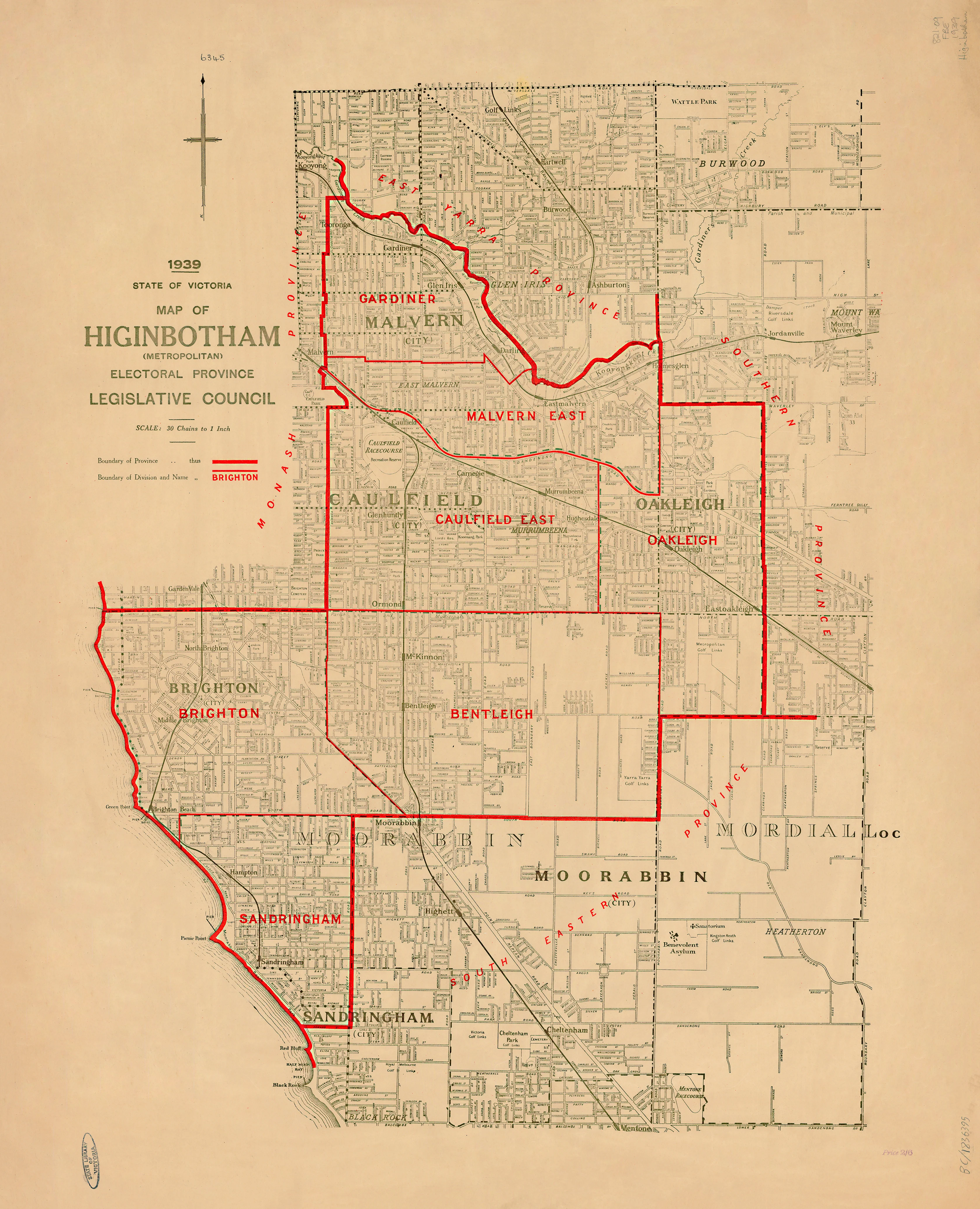
Higinbotham Electoral Map, Victoria (1939)
1939 — State of Victoria
Higinbotham (Metropolitan) Electoral Province
Legislative Council Electoral Map
This official 1939 electoral map of the Higinbotham (Metropolitan) Electoral Province records the Legislative Council boundaries in use across inner-metropolitan Melbourne on the eve of the Second World War. Prepared and issued by the Department of Crown Lands and Survey, it reflects the precision and clarity that defined late-interwar Victorian government cartography.
Named for George Higinbotham—jurist, parliamentarian, and leading advocate of responsible government—the province encompassed long-established suburbs where population density, civic institutions, and political life were already deeply rooted within Victoria.
Created as a functional government document, this map’s restrained design and exacting scale now make it an authoritative historical reference.
🗳️ What the Map Shows
-
The full extent of the Higinbotham (Metropolitan) Electoral Province
-
Clearly defined Legislative Council electoral boundaries
-
Detailed metropolitan street and suburb structure appropriate to its large scale
-
Clean, disciplined linework with minimal ornamentation
-
A single-province focus, free from statewide clutter
📜 Historical Context
Issued in 1939, this map captures Melbourne’s electoral geography at a pivotal moment—after decades of urban consolidation but before the demographic and political shifts of the post-war period. It preserves a pre-war Legislative Council framework, invaluable for understanding how representation was structured in inner-city Victoria during the late interwar years.
🧭 Cartographic Character
-
Official Victorian Government drafting standards
-
Large working scale
-
Boundary accuracy prioritised over decorative elements
-
A strong example of 1930s metropolitan electoral mapping
✨ Premium Print & Display Options
Each copy is printed in Australia using archival processes to preserve the original linework and tonal balance.
| Finish | Description |
|---|---|
| 📄 Heavyweight Paper (160 gsm matte) | Archival matte surface with excellent definition; ideal for framing under glass. |
| 🔒 Laminated (True Encapsulation) | Sealed between 2 × 80-micron gloss laminate; tear-resistant, wipe-clean, and durable. |
| 🎨 Archival Canvas (395 gsm HP Professional Matte) | Pigment-based, fade-resistant inks with strong visual presence. |
| 🪵 Laminated + Timber Hang Rails | Natural lacquered timber rails, ready to hang (allow up to 10 working days). |
| 🪵 Canvas + Timber Hang Rails | Gallery-ready, frame-free finish (allow up to 10 working days). |
📐 Size (W × H)
810 mm × 1000 mm
Orientation: Portrait
Custom sizing: Available on request.
🎯 Ideal For
-
Victorian electoral and parliamentary history collections
-
Melbourne metropolitan studies
-
Libraries, universities, and archives
-
Civic offices and council chambers
-
Collectors of Australian government and political maps
🤝 Our Commitment
Every map is printed in Australia, carefully colour-managed, and quality-checked to honour the original 1939 government issue.
A precise, authoritative record of Melbourne’s Higinbotham electorate—captured at a defining moment in Victoria’s political history.
Original: $64.36
-65%$64.36
$22.53Product Information
Product Information
Shipping & Returns
Shipping & Returns
Description
1939 — State of Victoria
Higinbotham (Metropolitan) Electoral Province
Legislative Council Electoral Map
This official 1939 electoral map of the Higinbotham (Metropolitan) Electoral Province records the Legislative Council boundaries in use across inner-metropolitan Melbourne on the eve of the Second World War. Prepared and issued by the Department of Crown Lands and Survey, it reflects the precision and clarity that defined late-interwar Victorian government cartography.
Named for George Higinbotham—jurist, parliamentarian, and leading advocate of responsible government—the province encompassed long-established suburbs where population density, civic institutions, and political life were already deeply rooted within Victoria.
Created as a functional government document, this map’s restrained design and exacting scale now make it an authoritative historical reference.
🗳️ What the Map Shows
-
The full extent of the Higinbotham (Metropolitan) Electoral Province
-
Clearly defined Legislative Council electoral boundaries
-
Detailed metropolitan street and suburb structure appropriate to its large scale
-
Clean, disciplined linework with minimal ornamentation
-
A single-province focus, free from statewide clutter
📜 Historical Context
Issued in 1939, this map captures Melbourne’s electoral geography at a pivotal moment—after decades of urban consolidation but before the demographic and political shifts of the post-war period. It preserves a pre-war Legislative Council framework, invaluable for understanding how representation was structured in inner-city Victoria during the late interwar years.
🧭 Cartographic Character
-
Official Victorian Government drafting standards
-
Large working scale
-
Boundary accuracy prioritised over decorative elements
-
A strong example of 1930s metropolitan electoral mapping
✨ Premium Print & Display Options
Each copy is printed in Australia using archival processes to preserve the original linework and tonal balance.
| Finish | Description |
|---|---|
| 📄 Heavyweight Paper (160 gsm matte) | Archival matte surface with excellent definition; ideal for framing under glass. |
| 🔒 Laminated (True Encapsulation) | Sealed between 2 × 80-micron gloss laminate; tear-resistant, wipe-clean, and durable. |
| 🎨 Archival Canvas (395 gsm HP Professional Matte) | Pigment-based, fade-resistant inks with strong visual presence. |
| 🪵 Laminated + Timber Hang Rails | Natural lacquered timber rails, ready to hang (allow up to 10 working days). |
| 🪵 Canvas + Timber Hang Rails | Gallery-ready, frame-free finish (allow up to 10 working days). |
📐 Size (W × H)
810 mm × 1000 mm
Orientation: Portrait
Custom sizing: Available on request.
🎯 Ideal For
-
Victorian electoral and parliamentary history collections
-
Melbourne metropolitan studies
-
Libraries, universities, and archives
-
Civic offices and council chambers
-
Collectors of Australian government and political maps
🤝 Our Commitment
Every map is printed in Australia, carefully colour-managed, and quality-checked to honour the original 1939 government issue.
A precise, authoritative record of Melbourne’s Higinbotham electorate—captured at a defining moment in Victoria’s political history.


