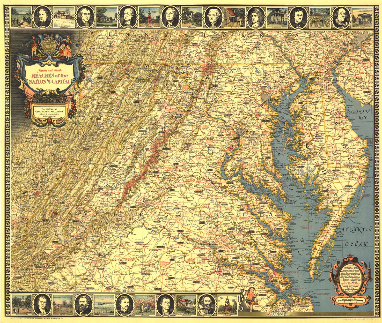
Historic and Scenic Reaches of the Nations Capital - Published 1938 by National Geographic
Illustrated Historical Map | Washington, D.C. & Surrounds | Large Wall Format (781 × 661 mm) | Premium Finishes
A beautifully illustrated map that blends cartography with storytelling, Historic and Scenic Reaches of the Nation’s Capital captures the cultural landscape surrounding Washington, D.C. in a richly decorative style. Published by National Geographic in July 1938 alongside the article “Roads from Washington,” this piece is as much artwork as it is a map.
Framed by a border of notable figures, landmarks, and historic scenes, it invites you to explore the region through both geography and narrative—revealing the places, people, and stories that shaped the American capital.
Why This Map Stands Out
A decorative cartographic artwork
Features an illustrated border celebrating key figures and historic sites.
A window into 1930s America
Reflects how the region around Washington, D.C. was understood and presented at the time.
Rich in historical detail
Includes notes and locations tied to significant events and landmarks.
Classic National Geographic style
Elegant, informative, and visually engaging.
Perfect for framing
A near-square format that works beautifully as a feature piece.
🗺️ What the Map Shows
- The region surrounding Washington, D.C., including key scenic routes
- Historic landmarks, towns, and places of interest
- Illustrated border featuring notable figures and locations
- Travel routes radiating from the capital
- Historical notes providing cultural and geographic context
- A visual narrative connecting place, history, and identity
📐 Size & Format
781 mm (W) × 661 mm (H)
Landscape orientation (near-square)
A balanced and decorative format ideal for:
- Framed display in living rooms or studies
- Offices and heritage-themed interiors
- Libraries and collections of historical maps
- Feature walls with a classic, artistic aesthetic
✨ Premium Finishes
| Format | Description |
|---|---|
| 📜 Paper (160 gsm) | Heavyweight matte-coated paper—ideal for framing. Preserves fine illustration detail. |
| 🧼 Laminated (Encapsulated) | Sealed in 2 × 80-micron gloss laminate. Durable and wipe-clean while maintaining visual clarity. |
| 🪵 Laminated + Timber Hang Rails | Laminated map mounted with lacquered natural timber rails and hanging cord—ready to display. |
| 🖼️ Canvas (395 gsm HP Professional Matte) | Printed with archival pigment inks. Enhances colour richness and artistic texture. |
| 🪵 Canvas + Timber Hang Rails | Canvas paired with timber rails for a refined, gallery-style presentation. |
🔨 Please allow up to 10 working days for professionally mounted hang-railed finishes.
📊 Specifications
| Feature | Detail |
|---|---|
| Title | Historic and Scenic Reaches of the Nation’s Capital |
| Publisher | National Geographic |
| Published | 1938 |
| Dimensions | 781 mm × 661 mm |
| Orientation | Landscape |
| Map Type | Historical / Illustrated |
| Coverage | Washington, D.C. region |
| Collections | USA, Historical |
| Materials | 160 gsm matte paper / 2 × 80-micron laminate / 395 gsm HP Professional Matte Canvas |
| Printing | Pigment-based, fade-resistant inks |
| Origin | Printed in Australia |
🎯 Ideal For
- Collectors of vintage National Geographic maps
- Enthusiasts of American history and heritage
- Interiors seeking a decorative, story-rich artwork
- Educators and students exploring regional history
- Gift buyers looking for a unique and elegant map
🏛️ A Capital Framed by History
This map captures more than geography:
- Roads leading outward from the nation’s capital
- Landscapes shaped by history and culture
- Figures and places that defined an era
- A region where travel, heritage, and identity meet
It is both a map and a narrative—offering a glimpse into how the capital and its surroundings were celebrated in the early 20th century.
🤝 Our Commitment
- Printed in Australia using archival-quality production
- Faithfully reproduced to preserve colour, detail, and illustration quality
- Premium materials selected for durability and long-term display
- Each map is hand-checked before dispatch
- Carefully packaged for safe delivery
🚚 Delivery
- Paper, Laminated, Canvas (rolled): Dispatch within 1–2 business days
- Hang-Railed Maps: Made to order—allow up to 10 working days
- Packaging: Securely rolled in protective tubing
Step back into a richly illustrated past—
a map that brings the nation’s capital and its heritage vividly to life.
👉 Order now and own a timeless piece of cartographic art.
Original: $57.20
-65%$57.20
$20.02Product Information
Product Information
Shipping & Returns
Shipping & Returns
Description
Illustrated Historical Map | Washington, D.C. & Surrounds | Large Wall Format (781 × 661 mm) | Premium Finishes
A beautifully illustrated map that blends cartography with storytelling, Historic and Scenic Reaches of the Nation’s Capital captures the cultural landscape surrounding Washington, D.C. in a richly decorative style. Published by National Geographic in July 1938 alongside the article “Roads from Washington,” this piece is as much artwork as it is a map.
Framed by a border of notable figures, landmarks, and historic scenes, it invites you to explore the region through both geography and narrative—revealing the places, people, and stories that shaped the American capital.
Why This Map Stands Out
A decorative cartographic artwork
Features an illustrated border celebrating key figures and historic sites.
A window into 1930s America
Reflects how the region around Washington, D.C. was understood and presented at the time.
Rich in historical detail
Includes notes and locations tied to significant events and landmarks.
Classic National Geographic style
Elegant, informative, and visually engaging.
Perfect for framing
A near-square format that works beautifully as a feature piece.
🗺️ What the Map Shows
- The region surrounding Washington, D.C., including key scenic routes
- Historic landmarks, towns, and places of interest
- Illustrated border featuring notable figures and locations
- Travel routes radiating from the capital
- Historical notes providing cultural and geographic context
- A visual narrative connecting place, history, and identity
📐 Size & Format
781 mm (W) × 661 mm (H)
Landscape orientation (near-square)
A balanced and decorative format ideal for:
- Framed display in living rooms or studies
- Offices and heritage-themed interiors
- Libraries and collections of historical maps
- Feature walls with a classic, artistic aesthetic
✨ Premium Finishes
| Format | Description |
|---|---|
| 📜 Paper (160 gsm) | Heavyweight matte-coated paper—ideal for framing. Preserves fine illustration detail. |
| 🧼 Laminated (Encapsulated) | Sealed in 2 × 80-micron gloss laminate. Durable and wipe-clean while maintaining visual clarity. |
| 🪵 Laminated + Timber Hang Rails | Laminated map mounted with lacquered natural timber rails and hanging cord—ready to display. |
| 🖼️ Canvas (395 gsm HP Professional Matte) | Printed with archival pigment inks. Enhances colour richness and artistic texture. |
| 🪵 Canvas + Timber Hang Rails | Canvas paired with timber rails for a refined, gallery-style presentation. |
🔨 Please allow up to 10 working days for professionally mounted hang-railed finishes.
📊 Specifications
| Feature | Detail |
|---|---|
| Title | Historic and Scenic Reaches of the Nation’s Capital |
| Publisher | National Geographic |
| Published | 1938 |
| Dimensions | 781 mm × 661 mm |
| Orientation | Landscape |
| Map Type | Historical / Illustrated |
| Coverage | Washington, D.C. region |
| Collections | USA, Historical |
| Materials | 160 gsm matte paper / 2 × 80-micron laminate / 395 gsm HP Professional Matte Canvas |
| Printing | Pigment-based, fade-resistant inks |
| Origin | Printed in Australia |
🎯 Ideal For
- Collectors of vintage National Geographic maps
- Enthusiasts of American history and heritage
- Interiors seeking a decorative, story-rich artwork
- Educators and students exploring regional history
- Gift buyers looking for a unique and elegant map
🏛️ A Capital Framed by History
This map captures more than geography:
- Roads leading outward from the nation’s capital
- Landscapes shaped by history and culture
- Figures and places that defined an era
- A region where travel, heritage, and identity meet
It is both a map and a narrative—offering a glimpse into how the capital and its surroundings were celebrated in the early 20th century.
🤝 Our Commitment
- Printed in Australia using archival-quality production
- Faithfully reproduced to preserve colour, detail, and illustration quality
- Premium materials selected for durability and long-term display
- Each map is hand-checked before dispatch
- Carefully packaged for safe delivery
🚚 Delivery
- Paper, Laminated, Canvas (rolled): Dispatch within 1–2 business days
- Hang-Railed Maps: Made to order—allow up to 10 working days
- Packaging: Securely rolled in protective tubing
Step back into a richly illustrated past—
a map that brings the nation’s capital and its heritage vividly to life.
👉 Order now and own a timeless piece of cartographic art.


