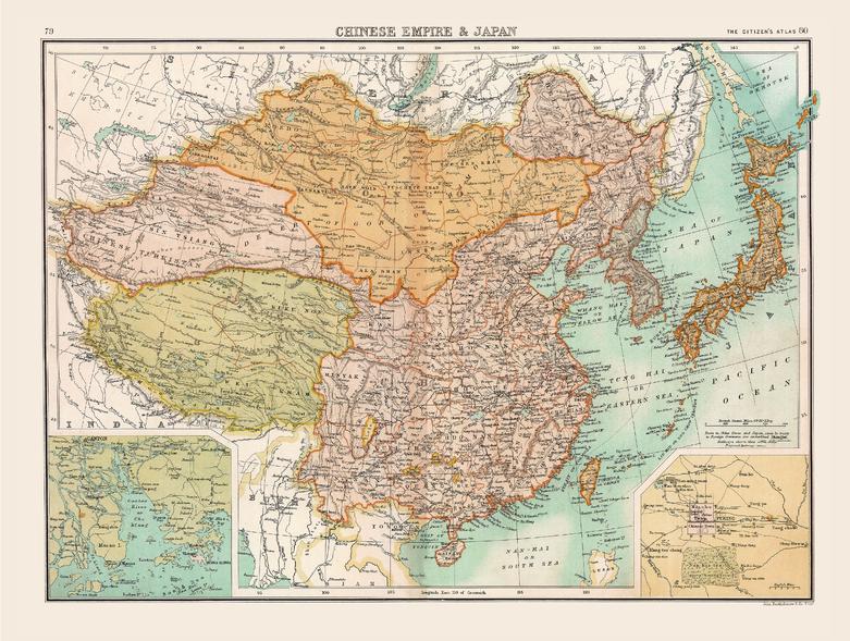
Historic Map of the Chinese Empire and Japan (1898) by Collins
Historic Map of the Chinese Empire and Japan — Collins (1898)
East Asia at the close of the 19th century — vast, complex, and on the edge of transformation.
Published in 1898 as part of The Citizen’s Atlas by John Bartholomew & Co. Ltd. for Collins, this full-colour map captures the Chinese Empire, Japan, Korea, Tibet, Mongolia, and Chinese Turkistan in one coherent and beautifully balanced composition. It is a map that speaks quietly but powerfully—clear borders, refined colour, and disciplined typography revealing a region poised between tradition and modernity.
🗺️ At a Glance
- Date: 1898
- Publisher: Collins (The Citizen’s Atlas)
- Cartography: John Bartholomew & Co. Ltd.
- Coverage: China, Japan, Korea, Tibet, Mongolia, Chinese Turkistan
- Insets: Peking (Beijing); Chu Kiang (Canton / Pearl River)
- Size: 1000 × 754 mm (Landscape)
✨ Why it captivates
- Imperial-era snapshot — East Asia before the upheavals of the 20th century
- Bartholomew precision — renowned for clarity, balance, and legibility
- Pan-regional view — unifies Central and East Asia in a single sheet
- Inset storytelling — detailed views of Beijing and the Pearl River system
- Decorative authority — visually elegant while grounded in real cartographic rigour
- Then-and-now potential — ideal for pairing with a modern political map
🔍 What you’ll see
- The Chinese Empire in full — shown in its late-Qing territorial extent
- Japan emerging — a modernising nation clearly defined alongside continental powers
- Korea, Mongolia & Tibet — mapped as distinct regions with geopolitical relevance
- Chinese Turkistan — offering valuable Central Asian context often absent from modern maps
- Clean political boundaries — carefully delineated for clarity and study
-
Inset detail:
- Peking (Beijing) — the imperial capital in focused detail
- Chu Kiang (Pearl River / Canton River) — a vital commercial artery
📜 A richer historical frame
This map was produced in 1898, at a moment when East Asia stood at a crossroads:
- The Qing Dynasty still ruled China, though under increasing internal and external pressure
- Japan, following the Meiji Restoration, had rapidly modernised and asserted regional influence
- Korea was a focal point of geopolitical tension
- Central Asian regions such as Chinese Turkistan reflected the vast reach—and fragility—of imperial control
Created by John Bartholomew & Co. Ltd., one of the great names in British cartography, the map embodies the era’s highest standards: precise, restrained, and highly readable. Today, it serves as both a historical artefact and a compelling visual narrative of a region in transition.
🎨 Choose your finish
Heavyweight Paper (160 gsm matte)
Archival-quality paper with a smooth matte finish—ideal for framing under glass.
Laminated (True Encapsulation)
Sealed in 2 × 80-micron gloss laminate—durable, wipe-clean, and moisture-resistant.
Laminated + Timber Hang Rails (Ready to hang)
Natural timber rails with hanging cord.
Please allow up to 10 working days.
Archival Canvas (395 gsm HP Professional Matte)
Museum-grade canvas with pigment-based, fade-resistant inks for rich depth and texture.
Canvas + Timber Hang Rails (Gallery-ready)
Canvas with timber rails for a refined, ready-to-hang display.
Please allow up to 10 working days.
📐 Size (W × H)
- 1000 × 754 mm (39.4 × 29.7 inches)
- Orientation: Landscape
- Aspect Ratio: ~1.33:1
- Framing: Custom framing recommended
-
Tips:
- Mat window overlap of 2–3 mm for a clean finish
- Float-mount option adds a gallery-style presentation
- Custom sizing: Available on request
📊 Specifications
| Feature | Details |
|---|---|
| Title | Historic Map of the Chinese Empire and Japan |
| Publisher | Collins — The Citizen’s Atlas |
| Cartographer | John Bartholomew & Co. Ltd. |
| Date | 1898 |
| Coverage | China, Japan, Korea, Tibet, Mongolia, Chinese Turkistan |
| Insets | Peking (Beijing); Chu Kiang (Pearl River) |
| Historical Context | Late Qing Dynasty; Meiji-era Japan; pre-20th century East Asia |
| Print Size | 1000 × 754 mm |
| Available Finishes | Paper, Laminated, Laminated + Timber Hang Rails, Canvas, Canvas + Timber Hang Rails |
| Paper Weight | 160 gsm archival matte |
| Laminate | 2 × 80-micron gloss (true encapsulation) |
| Canvas | 395 gsm HP Professional Matte Canvas |
| Inks | Pigment-based, fade-resistant |
| Hang Rails | Natural timber; allow up to 10 working days |
| Origin | Printed in Australia |
🎯 Who it’s for
- Historians & educators — teaching imperial and modern Asian history
- Collectors — seeking authentic atlas-era cartography
- Libraries & institutions — combining visual appeal with academic value
- Interior designers — refined, intellectual wall décor
- Travellers & enthusiasts — drawn to the story of East Asia
🤝 Our Commitment
Every map is printed in Australia using premium archival materials and carefully colour-managed to honour the original cartography. Each piece is hand-checked and packed with care, ensuring it arrives ready to inform, inspire, and endure.
A map of empires, transitions, and enduring geography—bring 1898 East Asia to your wall today.
Product Information
Product Information
Shipping & Returns
Shipping & Returns
Description
Historic Map of the Chinese Empire and Japan — Collins (1898)
East Asia at the close of the 19th century — vast, complex, and on the edge of transformation.
Published in 1898 as part of The Citizen’s Atlas by John Bartholomew & Co. Ltd. for Collins, this full-colour map captures the Chinese Empire, Japan, Korea, Tibet, Mongolia, and Chinese Turkistan in one coherent and beautifully balanced composition. It is a map that speaks quietly but powerfully—clear borders, refined colour, and disciplined typography revealing a region poised between tradition and modernity.
🗺️ At a Glance
- Date: 1898
- Publisher: Collins (The Citizen’s Atlas)
- Cartography: John Bartholomew & Co. Ltd.
- Coverage: China, Japan, Korea, Tibet, Mongolia, Chinese Turkistan
- Insets: Peking (Beijing); Chu Kiang (Canton / Pearl River)
- Size: 1000 × 754 mm (Landscape)
✨ Why it captivates
- Imperial-era snapshot — East Asia before the upheavals of the 20th century
- Bartholomew precision — renowned for clarity, balance, and legibility
- Pan-regional view — unifies Central and East Asia in a single sheet
- Inset storytelling — detailed views of Beijing and the Pearl River system
- Decorative authority — visually elegant while grounded in real cartographic rigour
- Then-and-now potential — ideal for pairing with a modern political map
🔍 What you’ll see
- The Chinese Empire in full — shown in its late-Qing territorial extent
- Japan emerging — a modernising nation clearly defined alongside continental powers
- Korea, Mongolia & Tibet — mapped as distinct regions with geopolitical relevance
- Chinese Turkistan — offering valuable Central Asian context often absent from modern maps
- Clean political boundaries — carefully delineated for clarity and study
-
Inset detail:
- Peking (Beijing) — the imperial capital in focused detail
- Chu Kiang (Pearl River / Canton River) — a vital commercial artery
📜 A richer historical frame
This map was produced in 1898, at a moment when East Asia stood at a crossroads:
- The Qing Dynasty still ruled China, though under increasing internal and external pressure
- Japan, following the Meiji Restoration, had rapidly modernised and asserted regional influence
- Korea was a focal point of geopolitical tension
- Central Asian regions such as Chinese Turkistan reflected the vast reach—and fragility—of imperial control
Created by John Bartholomew & Co. Ltd., one of the great names in British cartography, the map embodies the era’s highest standards: precise, restrained, and highly readable. Today, it serves as both a historical artefact and a compelling visual narrative of a region in transition.
🎨 Choose your finish
Heavyweight Paper (160 gsm matte)
Archival-quality paper with a smooth matte finish—ideal for framing under glass.
Laminated (True Encapsulation)
Sealed in 2 × 80-micron gloss laminate—durable, wipe-clean, and moisture-resistant.
Laminated + Timber Hang Rails (Ready to hang)
Natural timber rails with hanging cord.
Please allow up to 10 working days.
Archival Canvas (395 gsm HP Professional Matte)
Museum-grade canvas with pigment-based, fade-resistant inks for rich depth and texture.
Canvas + Timber Hang Rails (Gallery-ready)
Canvas with timber rails for a refined, ready-to-hang display.
Please allow up to 10 working days.
📐 Size (W × H)
- 1000 × 754 mm (39.4 × 29.7 inches)
- Orientation: Landscape
- Aspect Ratio: ~1.33:1
- Framing: Custom framing recommended
-
Tips:
- Mat window overlap of 2–3 mm for a clean finish
- Float-mount option adds a gallery-style presentation
- Custom sizing: Available on request
📊 Specifications
| Feature | Details |
|---|---|
| Title | Historic Map of the Chinese Empire and Japan |
| Publisher | Collins — The Citizen’s Atlas |
| Cartographer | John Bartholomew & Co. Ltd. |
| Date | 1898 |
| Coverage | China, Japan, Korea, Tibet, Mongolia, Chinese Turkistan |
| Insets | Peking (Beijing); Chu Kiang (Pearl River) |
| Historical Context | Late Qing Dynasty; Meiji-era Japan; pre-20th century East Asia |
| Print Size | 1000 × 754 mm |
| Available Finishes | Paper, Laminated, Laminated + Timber Hang Rails, Canvas, Canvas + Timber Hang Rails |
| Paper Weight | 160 gsm archival matte |
| Laminate | 2 × 80-micron gloss (true encapsulation) |
| Canvas | 395 gsm HP Professional Matte Canvas |
| Inks | Pigment-based, fade-resistant |
| Hang Rails | Natural timber; allow up to 10 working days |
| Origin | Printed in Australia |
🎯 Who it’s for
- Historians & educators — teaching imperial and modern Asian history
- Collectors — seeking authentic atlas-era cartography
- Libraries & institutions — combining visual appeal with academic value
- Interior designers — refined, intellectual wall décor
- Travellers & enthusiasts — drawn to the story of East Asia
🤝 Our Commitment
Every map is printed in Australia using premium archival materials and carefully colour-managed to honour the original cartography. Each piece is hand-checked and packed with care, ensuring it arrives ready to inform, inspire, and endure.
A map of empires, transitions, and enduring geography—bring 1898 East Asia to your wall today.


