Indian Country by National Geographic
Thematic Wall Map | Native Nations, Lands & Living Culture | Large Format (791 × 511 mm) | Premium Finishes
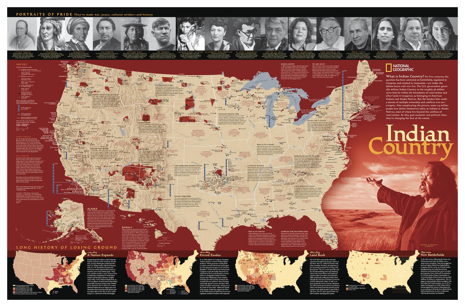
A powerful and respectful exploration of Native American history and presence, Indian Country maps the enduring geography of Indigenous nations across the United States. Published by National Geographic in 2016, this richly detailed map brings together territory, culture, and history—revealing both the scale of Native lands today and the story of how they have changed over time.
From reservations and trust lands to festivals and cultural gatherings, it presents a living landscape shaped by resilience, identity, and continuity.
Why This Map Stands Out
A map of living nations
Shows Native American reservations, tribal lands, and cultural regions across the United States.
Historical depth and context
Includes a powerful series of maps tracing land change from 1775 to the present.
Celebrates culture and identity
Highlights festivals, pow-wows, and cultural centres.
Profiles notable figures
Features images and short biographies of influential Native Americans.
National Geographic authority
Thoughtfully designed, accurate, and deeply informative.
🗺️ What the Map Shows
- Locations of Native American reservations and tribal entities
- Trust lands and areas of Indigenous governance
- Cultural sites including festivals and pow-wows
- A series of inset maps illustrating the loss of Native lands over time (1775–present)
- Biographical highlights of notable Indigenous figures
- A comprehensive view of Indigenous presence across the United States
📐 Size & Format
791 mm (W) × 511 mm (H)
Landscape orientation
A balanced format ideal for:
- Classrooms and educational environments
- Cultural centres and institutions
- Home studies and libraries
- Interiors focused on history and heritage
✨ Premium Finishes
| Format | Description |
|---|---|
| 📜 Paper (160 gsm) | Heavyweight matte-coated paper—ideal for framing. Preserves clarity and detail. |
| 🧼 Laminated (Encapsulated) | Sealed in 2 × 80-micron gloss laminate. Durable, wipe-clean, and suitable for reference. |
| 🪵 Laminated + Timber Hang Rails | Laminated map mounted with lacquered natural timber rails and hanging cord—ready to display. |
| 🖼️ Canvas (395 gsm HP Professional Matte) | Printed with archival pigment inks. Enhances depth and presentation. |
| 🪵 Canvas + Timber Hang Rails | Canvas paired with timber rails for a refined, gallery-style display. |
🔨 Please allow up to 10 working days for professionally mounted hang-railed finishes.
📊 Specifications
| Feature | Detail |
|---|---|
| Title | Indian Country |
| Publisher | National Geographic |
| Published | 2016 |
| Scale | 1:7,328,000 |
| Dimensions | 791 mm × 511 mm |
| Orientation | Landscape |
| Map Type | Thematic / Cultural / Historical |
| Coverage | United States (Native American lands) |
| Collections | USA, Thematic |
| Materials | 160 gsm matte paper / 2 × 80-micron laminate / 395 gsm HP Professional Matte Canvas |
| Printing | Pigment-based, fade-resistant inks |
| Origin | Printed in Australia |
🎯 Ideal For
- Students and educators of Indigenous history and culture
- Cultural institutions and community organisations
- Collectors of National Geographic thematic maps
- Individuals interested in Native American heritage and geography
- Gift buyers seeking a meaningful and educational map
🪶 A Story of Land and Identity
For centuries, Indigenous lands have been:
- Contested, reshaped, and redefined
- Central to culture, community, and identity
- Sites of resilience and continuity
- Living landscapes—not just history
This map captures that reality—showing a story that is ongoing, not complete.
🤝 Our Commitment
- Printed in Australia using archival-quality production
- Faithfully reproduced to preserve clarity and cultural detail
- Premium materials selected for durability and longevity
- Each map is hand-checked before dispatch
- Carefully packaged for safe delivery
🚚 Delivery
- Paper, Laminated, Canvas (rolled): Dispatch within 1–2 business days
- Hang-Railed Maps: Made to order—allow up to 10 working days
- Packaging: Securely rolled in protective tubing
Understand the land through its original custodians—
a map that brings Indigenous history, culture, and presence into clear focus.
👉 Order now and add a powerful cultural perspective to your wall.
Original: $57.20
-65%$57.20
$20.02Product Information
Product Information
Shipping & Returns
Shipping & Returns
Description
Thematic Wall Map | Native Nations, Lands & Living Culture | Large Format (791 × 511 mm) | Premium Finishes
A powerful and respectful exploration of Native American history and presence, Indian Country maps the enduring geography of Indigenous nations across the United States. Published by National Geographic in 2016, this richly detailed map brings together territory, culture, and history—revealing both the scale of Native lands today and the story of how they have changed over time.
From reservations and trust lands to festivals and cultural gatherings, it presents a living landscape shaped by resilience, identity, and continuity.
Why This Map Stands Out
A map of living nations
Shows Native American reservations, tribal lands, and cultural regions across the United States.
Historical depth and context
Includes a powerful series of maps tracing land change from 1775 to the present.
Celebrates culture and identity
Highlights festivals, pow-wows, and cultural centres.
Profiles notable figures
Features images and short biographies of influential Native Americans.
National Geographic authority
Thoughtfully designed, accurate, and deeply informative.
🗺️ What the Map Shows
- Locations of Native American reservations and tribal entities
- Trust lands and areas of Indigenous governance
- Cultural sites including festivals and pow-wows
- A series of inset maps illustrating the loss of Native lands over time (1775–present)
- Biographical highlights of notable Indigenous figures
- A comprehensive view of Indigenous presence across the United States
📐 Size & Format
791 mm (W) × 511 mm (H)
Landscape orientation
A balanced format ideal for:
- Classrooms and educational environments
- Cultural centres and institutions
- Home studies and libraries
- Interiors focused on history and heritage
✨ Premium Finishes
| Format | Description |
|---|---|
| 📜 Paper (160 gsm) | Heavyweight matte-coated paper—ideal for framing. Preserves clarity and detail. |
| 🧼 Laminated (Encapsulated) | Sealed in 2 × 80-micron gloss laminate. Durable, wipe-clean, and suitable for reference. |
| 🪵 Laminated + Timber Hang Rails | Laminated map mounted with lacquered natural timber rails and hanging cord—ready to display. |
| 🖼️ Canvas (395 gsm HP Professional Matte) | Printed with archival pigment inks. Enhances depth and presentation. |
| 🪵 Canvas + Timber Hang Rails | Canvas paired with timber rails for a refined, gallery-style display. |
🔨 Please allow up to 10 working days for professionally mounted hang-railed finishes.
📊 Specifications
| Feature | Detail |
|---|---|
| Title | Indian Country |
| Publisher | National Geographic |
| Published | 2016 |
| Scale | 1:7,328,000 |
| Dimensions | 791 mm × 511 mm |
| Orientation | Landscape |
| Map Type | Thematic / Cultural / Historical |
| Coverage | United States (Native American lands) |
| Collections | USA, Thematic |
| Materials | 160 gsm matte paper / 2 × 80-micron laminate / 395 gsm HP Professional Matte Canvas |
| Printing | Pigment-based, fade-resistant inks |
| Origin | Printed in Australia |
🎯 Ideal For
- Students and educators of Indigenous history and culture
- Cultural institutions and community organisations
- Collectors of National Geographic thematic maps
- Individuals interested in Native American heritage and geography
- Gift buyers seeking a meaningful and educational map
🪶 A Story of Land and Identity
For centuries, Indigenous lands have been:
- Contested, reshaped, and redefined
- Central to culture, community, and identity
- Sites of resilience and continuity
- Living landscapes—not just history
This map captures that reality—showing a story that is ongoing, not complete.
🤝 Our Commitment
- Printed in Australia using archival-quality production
- Faithfully reproduced to preserve clarity and cultural detail
- Premium materials selected for durability and longevity
- Each map is hand-checked before dispatch
- Carefully packaged for safe delivery
🚚 Delivery
- Paper, Laminated, Canvas (rolled): Dispatch within 1–2 business days
- Hang-Railed Maps: Made to order—allow up to 10 working days
- Packaging: Securely rolled in protective tubing
Understand the land through its original custodians—
a map that brings Indigenous history, culture, and presence into clear focus.
👉 Order now and add a powerful cultural perspective to your wall.


