Large-Format | WWII-Era Cartography | Premium Finishes
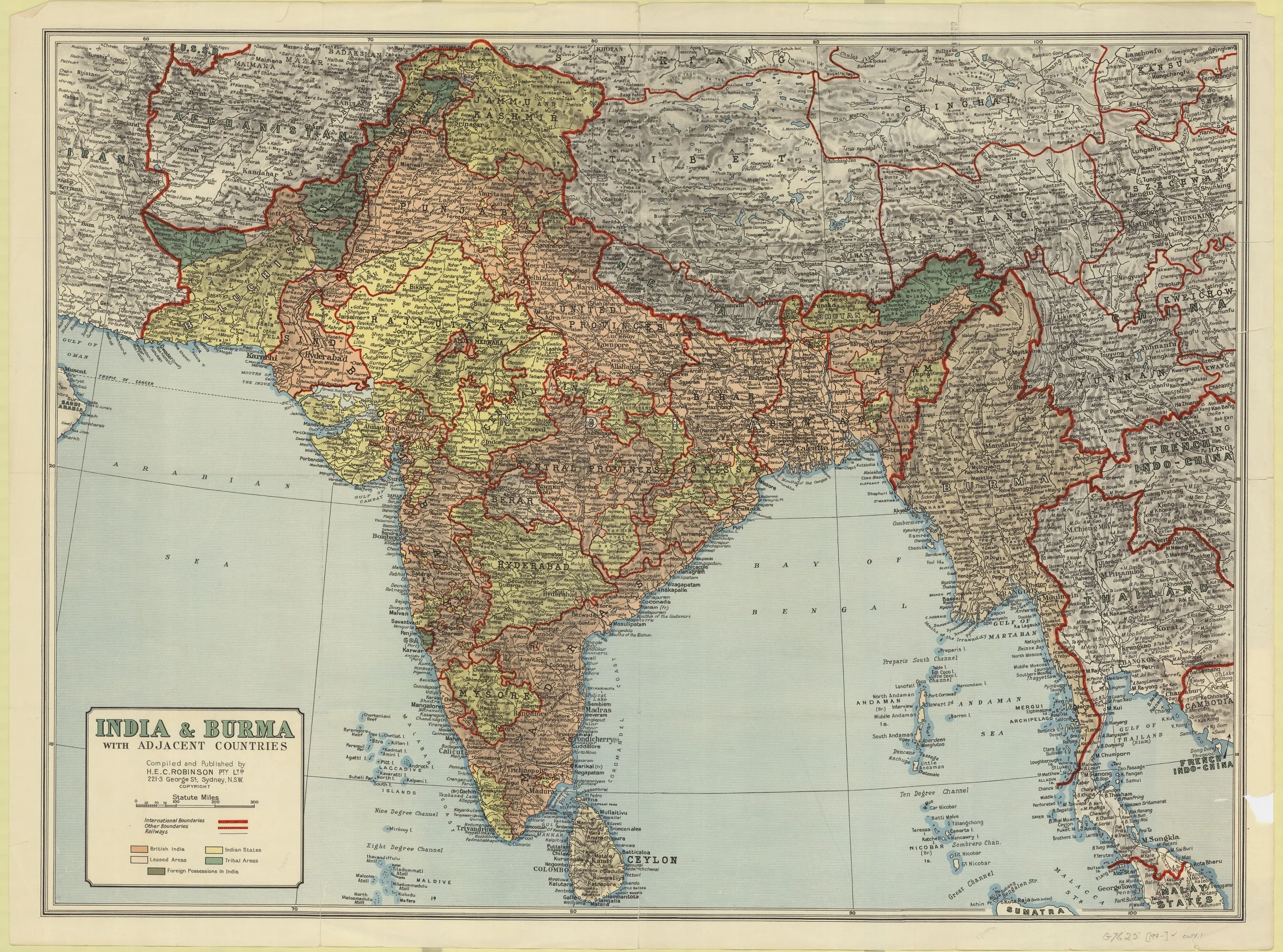
Journey back to the mid-20th century with this faithful wall reproduction of H.E.C. Robinson’s 1943 map of India & Burma (present-day Myanmar). Evocative wartime colourwork, elegant period typography, and meticulous town and village labelling capture the subcontinent at a pivotal moment in history—an inspiring centrepiece for libraries, studies, offices, classrooms, and lovers of vintage cartography.
🗺️ Map Features
-
Authentic 1943 Design
Meticulously reproduced from H.E.C. Robinson’s WWII-era cartography, reflecting the political and geographic understanding of the time. -
Remarkable Place-Name Density
Very detailed town and village locations—ideal for genealogy, research, and immersive historical study. -
Wartime Colour Palette
Beautiful, period-accurate colours with clear linework and label hierarchy for a true antique atlas aesthetic. -
Regional Context at a Glance
Rivers, ranges, provinces, and key routes rendered with clarity for instant orientation across India & Burma. -
Wall-Optimised Legibility
Crisp reproduction ensures clarity without clutter—reads beautifully from meeting-room or studio distance. -
Conversation Starter
A visually striking piece that invites stories, questions, and shared discoveries about the region’s past.
✨ Available Finishes
| Format | Description |
|---|---|
| 📜 Paper (160 gsm) | Heavyweight matte-coated paper—perfect for framing under glass. |
| 🧼 Laminated (Encapsulated) | Fully sealed in 80-micron gloss laminate for a durable, wipe-clean surface—great for classrooms and study spaces. |
| 🪵 Laminated with Wooden Hang Rails | Laminated map mounted with lacquered natural timber rails (top & bottom) and a hanging cord—ready to display. |
| 🖼️ Canvas (395 gsm) | Printed on HP Professional Matte Canvas with archival pigment-based inks—rich texture, fade-resistant, gallery quality. |
| 🪵 Canvas with Wooden Hang Rails | Canvas finished with lacquered timber rails and a hanging cord—timeless, frame-free presentation. |
🔨 Hang-railed maps are made to order—please allow up to 10 working days for professional mounting.
📐 Specifications
| Feature | Detail |
|---|---|
| Title | India & Burma Historic Wall Map (1943, H.E.C. Robinson) |
| Edition | Historical reproduction |
| Cartographer | H.E.C. Robinson |
| Map Type | Historical / Reference |
| Dimensions | 950 mm (W) × 710 mm (H) |
| Orientation | Landscape |
| Materials | Paper, Laminated, Canvas, With or Without Timber Rails |
| Printing | Pigment-based inks, fade-resistant |
| Language | English (period toponymy) |
💡 Why You’ll Love This Map
-
Emotionally resonant—a vivid WWII-era snapshot of the subcontinent.
-
Research-ready detail—towns and villages rarely shown on modern maps.
-
Quiet luxury—museum-style aesthetics for refined interiors.
-
Built to last—archival printing and premium substrates for years of enjoyment.
-
Flexible display—five premium finishes to match your space.
🚚 Delivery
-
Paper, Laminated, and Canvas (rolled): Usually ships within 1–2 business days.
-
Hang-railed versions: Made to order; allow up to 10 working days.
-
Packaging: Securely protected to arrive in pristine condition.
Let this wartime portrait of India & Burma anchor your wall—and your imagination. Follow the rivers, trace old place-names, and feel history breathe between the lines.


