Iran National Geographic 1450 x 1130 mm Wall Map
Political & Physical Detail | Shaded Relief | Large-Format Reference | Premium Finishes
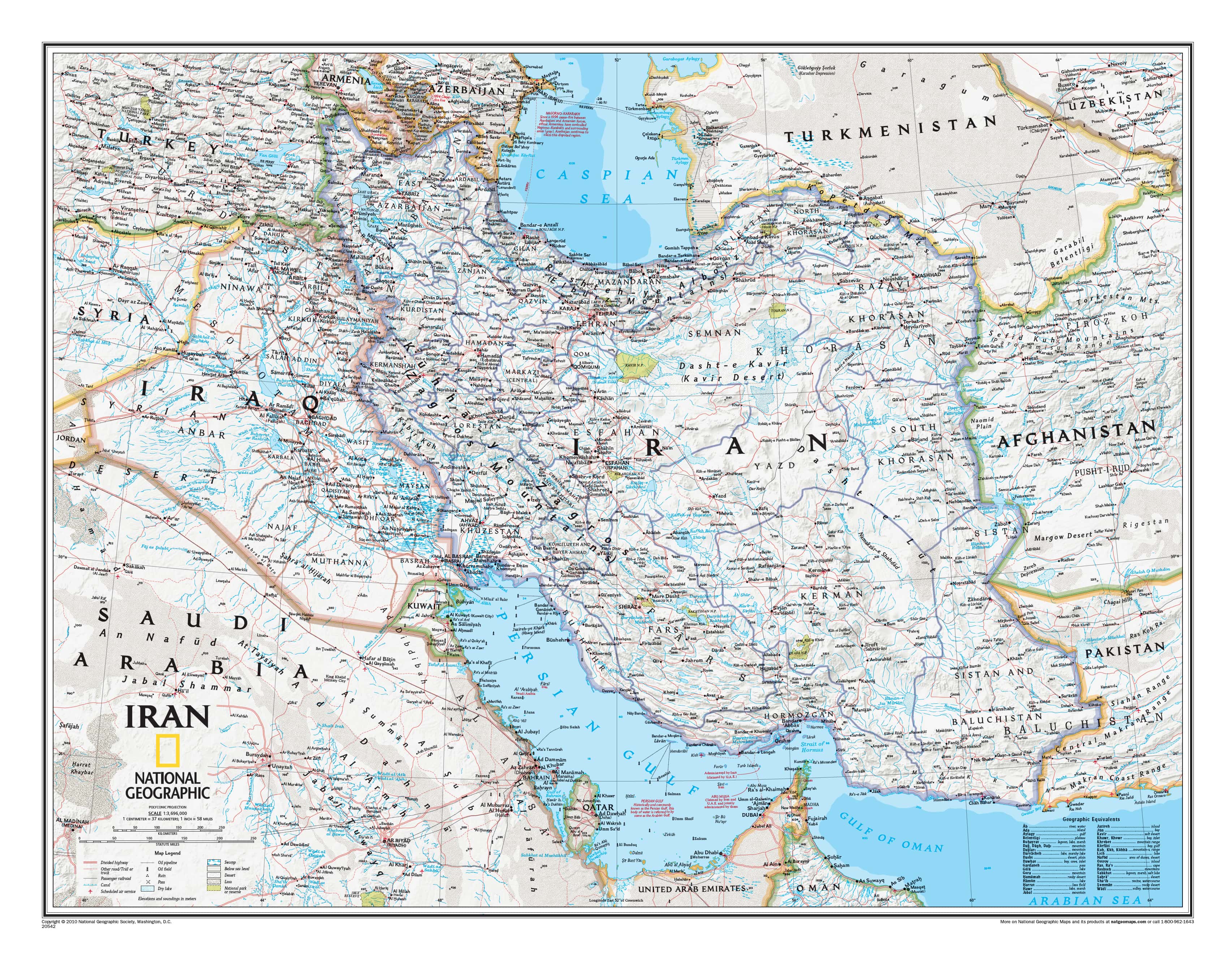
An expansive and authoritative portrait of Iran—a land where geography, history, and culture are inseparably linked—rendered with the clarity and precision that define National Geographic cartography.
At this impressive large format, Iran’s landscapes unfold in remarkable detail—from the sweeping ridgelines of the Zagros Mountains to the elevated arc of the Alborz Range, from the vast salt flats of Dasht-e Kavir to the arid expanse of Dasht-e Lut. Subtle shaded relief gives the terrain real depth, while refined political detail ensures that every boundary, city, and transport route is easy to interpret at a glance.
This is more than a map—it’s a geographic framework for understanding one of the world’s oldest and most influential civilisations.
⚓ Why This Map Stands Out
A landscape-driven nation revealed
Iran’s geography is dramatic and decisive—mountains, deserts, and coastlines shape everything from settlement to strategy. This map makes those relationships immediately visible.
National Geographic authority
Decades of cartographic expertise ensure a perfect balance of accuracy, clarity, and visual refinement.
Political clarity with physical richness
Administrative boundaries, cities, and infrastructure are layered seamlessly over terrain—delivering a complete, integrated view.
A region of enduring global importance
Positioned at the crossroads of the Middle East, Central Asia, and South Asia, Iran remains central to trade routes, energy flows, and geopolitics.
A true wall statement
At 1450 mm wide, this map commands attention—equally suited to boardrooms, classrooms, and sophisticated interiors.
🗺️ What the Map Shows
- Full national coverage of Iran, from the Caspian Sea coast to the Persian Gulf and Gulf of Oman
- Major cities including Tehran, Isfahan, Shiraz, Tabriz, and Mashhad
- Political boundaries and provincial divisions
- Extensive infrastructure: highways, railways, airports, pipelines, and energy corridors
- Mountain systems, deserts, rivers, and lakes rendered in shaded relief
- Key bodies of water including the Caspian Sea, Persian Gulf, and Strait of Hormuz
- Surrounding regions providing broader context across Iraq, Turkey, Afghanistan, Pakistan, and the Arabian Peninsula
This is Iran presented not just as a country—but as a connected geographic system shaped by terrain, resources, and movement.
📐 Size & Presence
1450 mm (W) × 1130 mm (H)
Landscape orientation
A commanding large-format map designed for environments where clarity and presence matter:
- Corporate offices and strategy rooms
- Universities and classrooms
- Libraries and research spaces
- Home offices and feature walls
✨ Premium Finishes
| Format | Description |
|---|---|
| 📜 Paper (160 gsm) | Heavyweight matte-coated paper—ideal for framing. Preserves fine detail with a clean, low-glare finish. |
| 🧼 Laminated (Encapsulated) | Sealed in 2 × 80-micron gloss laminate. Durable, wipe-clean, and suitable for annotation and repeated use. |
| 🪵 Laminated + Timber Hang Rails | Laminated map fitted with lacquered natural timber rails and hanging cord—ready to display. |
| 🖼️ Canvas (395 gsm HP Professional Matte) | Printed with archival pigment-based inks. Rich texture, reduced glare, and gallery-quality presentation. |
| 🪵 Canvas + Timber Hang Rails | Canvas paired with timber rails for a refined, frame-free display solution. |
🔨 Please allow up to 10 working days for professionally mounted hang-railed finishes.
📊 Specifications
| Feature | Detail |
|---|---|
| Title | Iran — National Geographic Wall Map |
| Dimensions | 1450 mm × 1130 mm |
| Map Type | Political / Physical with shaded relief |
| Coverage | Iran and surrounding regions |
| Detail | Cities, infrastructure, terrain, and boundaries |
| Materials | 160 gsm matte paper / 2 × 80-micron laminate / 395 gsm HP Professional Matte Canvas |
| Printing | Pigment-based, fade-resistant inks |
| Origin | Printed and finished in Australia |
🎯 Ideal For
- Educators and students exploring Middle Eastern geography and history
- Professionals needing a clear, large-scale regional reference
- Travellers and researchers planning across Iran and neighbouring countries
- Collectors of National Geographic maps
- Interiors seeking a visually compelling and intellectually engaging centrepiece
🌍 A Landscape That Shapes Civilisation
Iran’s geography is not incidental—it is foundational.
- The Zagros Mountains form natural barriers and cultural divides
- The central deserts influence settlement patterns and trade routes
- The Caspian lowlands support agriculture and dense populations
- The Persian Gulf coastline connects Iran to global energy networks
This map reveals how these elements interact—how terrain shapes movement, resources shape power, and geography shapes history.
It’s a perspective that transforms the map from a static image into a dynamic story of place.
🧭 Clarity at Scale
At this size, the map excels in environments where detail matters:
- Easily trace transport corridors and regional connections
- Identify relationships between cities and terrain
- Use laminated versions for planning, annotation, and discussion
- Appreciate the subtle balance of colour, typography, and relief from across the room
This is a map designed not just to be viewed—but to be used, studied, and lived with.
🤝 Our Commitment
- Printed in Australia using archival production methods
- Carefully colour-managed for accuracy and consistency
- Premium materials selected for longevity and durability
- Each map is hand-checked before dispatch
- Secure packaging to ensure it arrives in pristine condition
🚚 Delivery
- Paper, Laminated, Canvas (rolled): Dispatch within 1–2 business days
- Hang-Railed Maps: Made to order—allow up to 10 working days
- Packaging: Heavy-duty protective tube for safe delivery
Bring the scale, structure, and significance of Iran into clear focus—
a map that reveals not just where things are, but why they are there.
👉 Order now and experience one of the world’s great geographic landscapes in exceptional detail.
Original: $128.75
-65%$128.75
$45.06Product Information
Product Information
Shipping & Returns
Shipping & Returns
Description
Political & Physical Detail | Shaded Relief | Large-Format Reference | Premium Finishes
An expansive and authoritative portrait of Iran—a land where geography, history, and culture are inseparably linked—rendered with the clarity and precision that define National Geographic cartography.
At this impressive large format, Iran’s landscapes unfold in remarkable detail—from the sweeping ridgelines of the Zagros Mountains to the elevated arc of the Alborz Range, from the vast salt flats of Dasht-e Kavir to the arid expanse of Dasht-e Lut. Subtle shaded relief gives the terrain real depth, while refined political detail ensures that every boundary, city, and transport route is easy to interpret at a glance.
This is more than a map—it’s a geographic framework for understanding one of the world’s oldest and most influential civilisations.
⚓ Why This Map Stands Out
A landscape-driven nation revealed
Iran’s geography is dramatic and decisive—mountains, deserts, and coastlines shape everything from settlement to strategy. This map makes those relationships immediately visible.
National Geographic authority
Decades of cartographic expertise ensure a perfect balance of accuracy, clarity, and visual refinement.
Political clarity with physical richness
Administrative boundaries, cities, and infrastructure are layered seamlessly over terrain—delivering a complete, integrated view.
A region of enduring global importance
Positioned at the crossroads of the Middle East, Central Asia, and South Asia, Iran remains central to trade routes, energy flows, and geopolitics.
A true wall statement
At 1450 mm wide, this map commands attention—equally suited to boardrooms, classrooms, and sophisticated interiors.
🗺️ What the Map Shows
- Full national coverage of Iran, from the Caspian Sea coast to the Persian Gulf and Gulf of Oman
- Major cities including Tehran, Isfahan, Shiraz, Tabriz, and Mashhad
- Political boundaries and provincial divisions
- Extensive infrastructure: highways, railways, airports, pipelines, and energy corridors
- Mountain systems, deserts, rivers, and lakes rendered in shaded relief
- Key bodies of water including the Caspian Sea, Persian Gulf, and Strait of Hormuz
- Surrounding regions providing broader context across Iraq, Turkey, Afghanistan, Pakistan, and the Arabian Peninsula
This is Iran presented not just as a country—but as a connected geographic system shaped by terrain, resources, and movement.
📐 Size & Presence
1450 mm (W) × 1130 mm (H)
Landscape orientation
A commanding large-format map designed for environments where clarity and presence matter:
- Corporate offices and strategy rooms
- Universities and classrooms
- Libraries and research spaces
- Home offices and feature walls
✨ Premium Finishes
| Format | Description |
|---|---|
| 📜 Paper (160 gsm) | Heavyweight matte-coated paper—ideal for framing. Preserves fine detail with a clean, low-glare finish. |
| 🧼 Laminated (Encapsulated) | Sealed in 2 × 80-micron gloss laminate. Durable, wipe-clean, and suitable for annotation and repeated use. |
| 🪵 Laminated + Timber Hang Rails | Laminated map fitted with lacquered natural timber rails and hanging cord—ready to display. |
| 🖼️ Canvas (395 gsm HP Professional Matte) | Printed with archival pigment-based inks. Rich texture, reduced glare, and gallery-quality presentation. |
| 🪵 Canvas + Timber Hang Rails | Canvas paired with timber rails for a refined, frame-free display solution. |
🔨 Please allow up to 10 working days for professionally mounted hang-railed finishes.
📊 Specifications
| Feature | Detail |
|---|---|
| Title | Iran — National Geographic Wall Map |
| Dimensions | 1450 mm × 1130 mm |
| Map Type | Political / Physical with shaded relief |
| Coverage | Iran and surrounding regions |
| Detail | Cities, infrastructure, terrain, and boundaries |
| Materials | 160 gsm matte paper / 2 × 80-micron laminate / 395 gsm HP Professional Matte Canvas |
| Printing | Pigment-based, fade-resistant inks |
| Origin | Printed and finished in Australia |
🎯 Ideal For
- Educators and students exploring Middle Eastern geography and history
- Professionals needing a clear, large-scale regional reference
- Travellers and researchers planning across Iran and neighbouring countries
- Collectors of National Geographic maps
- Interiors seeking a visually compelling and intellectually engaging centrepiece
🌍 A Landscape That Shapes Civilisation
Iran’s geography is not incidental—it is foundational.
- The Zagros Mountains form natural barriers and cultural divides
- The central deserts influence settlement patterns and trade routes
- The Caspian lowlands support agriculture and dense populations
- The Persian Gulf coastline connects Iran to global energy networks
This map reveals how these elements interact—how terrain shapes movement, resources shape power, and geography shapes history.
It’s a perspective that transforms the map from a static image into a dynamic story of place.
🧭 Clarity at Scale
At this size, the map excels in environments where detail matters:
- Easily trace transport corridors and regional connections
- Identify relationships between cities and terrain
- Use laminated versions for planning, annotation, and discussion
- Appreciate the subtle balance of colour, typography, and relief from across the room
This is a map designed not just to be viewed—but to be used, studied, and lived with.
🤝 Our Commitment
- Printed in Australia using archival production methods
- Carefully colour-managed for accuracy and consistency
- Premium materials selected for longevity and durability
- Each map is hand-checked before dispatch
- Secure packaging to ensure it arrives in pristine condition
🚚 Delivery
- Paper, Laminated, Canvas (rolled): Dispatch within 1–2 business days
- Hang-Railed Maps: Made to order—allow up to 10 working days
- Packaging: Heavy-duty protective tube for safe delivery
Bring the scale, structure, and significance of Iran into clear focus—
a map that reveals not just where things are, but why they are there.
👉 Order now and experience one of the world’s great geographic landscapes in exceptional detail.