Physical & Political Detail | Tigris–Euphrates Basin | Premium Finishes
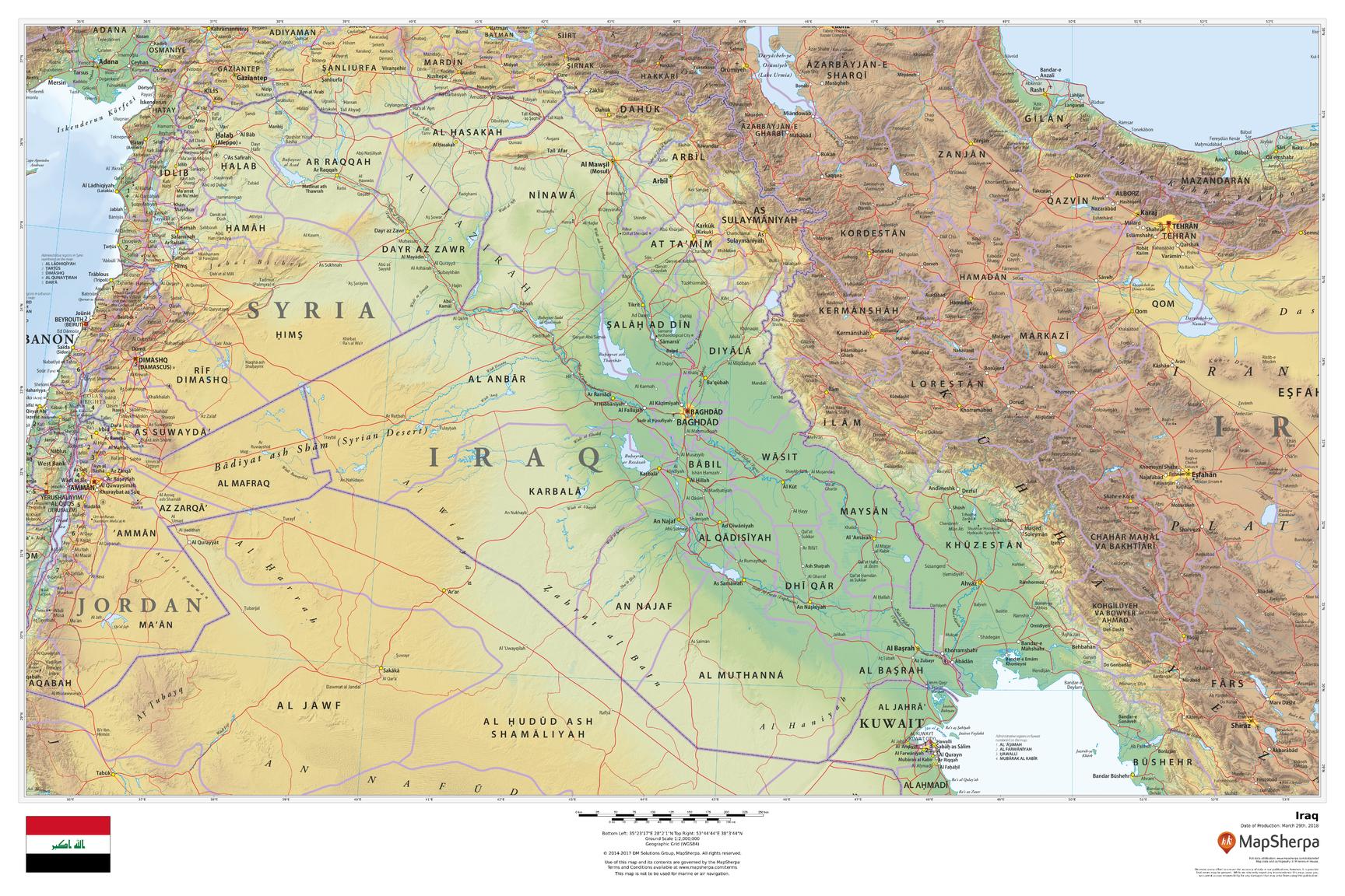
From the rugged Zagros Mountains to the fertile Mesopotamian plain and the Shatt al-Arab delta on the Persian Gulf, this wall map brings Iraq into sharp, elegant focus. Clear political boundaries overlay refined shaded relief and elevation tints so ranges, plateaus, and river corridors read instantly—perfect for classrooms, offices, and travel-inspired interiors.
🗺️ Map Features
-
Physical + Political Coverage – National borders, governorates (where shown), and major cities including Baghdad, Basra, Mosul, Erbil, Kirkuk, Najaf, Karbala, and Sulaymaniyah.
-
Relief Shading & Elevation Colours – Hillshading and hypsometric tints reveal the Zagros, Al-Jazira steppe, deserts of the west and south, and the alluvial lowlands.
-
Rivers & Wetlands – The Tigris and Euphrates with tributaries, marshlands, dams/reservoirs, and the Shatt al-Arab waterway clearly depicted.
-
Transport & Reference – Primary roads and rail (where depicted), key crossings, and a balanced label hierarchy for clarity without clutter at wall distance.
-
Regional Context – Neighbouring Turkey, Iran, Kuwait, Saudi Arabia, Jordan, and Syria shown for seamless geographic continuity.
All features appear as depicted on the printed map.
✨ Available Finishes
| Format | Description |
|---|---|
| 📜 Paper (160 gsm) | Heavyweight matte-coated paper—ideal for framing under glass. |
| 🧼 Laminated (Encapsulated) | Fully sealed in 80-micron gloss laminate—durable, wipe-clean, classroom-ready. |
| 🪵 Laminated with Wooden Hang Rails | Laminated map mounted with lacquered natural timber rails (top & bottom) and a hanging cord—ready to display. |
| 🖼️ Canvas (395 gsm) | HP Professional Matte Canvas with archival pigment-based inks—rich texture, fade-resistant, gallery-grade. |
| 🪵 Canvas with Wooden Hang Rails | Canvas finished with lacquered timber rails and a hanging cord—timeless, frame-free presentation. |
🔨 Hang-railed maps are made to order—please allow up to 10 working days for professional mounting.
📐 Specifications
| Feature | Detail |
|---|---|
| Title | Iraq Wall Map |
| Map Type | Physical / Political |
| Scale | 1:3,000,000 (≈ 1 cm = 30 km) |
| Dimensions | 914 mm (W) × 610 mm (H) |
| Orientation | Landscape |
| Materials | Paper, Laminated, Canvas, With or Without Timber Rails |
| Printing | Archival pigment-based inks, fade-resistant |
💡 Why You’ll Love It
-
River-to-range clarity—mountains, plains, and deltas rendered in elegant shaded relief.
-
Clean political framing supports teaching, planning, and presentations.
-
Five premium finishes to suit homes, offices, and classrooms.
-
Built to last—laminated and canvas options resist wear while keeping colours true.
🚚 Delivery
-
Paper, Laminated & Canvas (rolled): Usually ships within 1–2 business days.
-
Hang-railed versions: Made to order; allow up to 10 working days.
-
Packaging: Securely protected to arrive in pristine condition.
Bring Iraq’s historic heartland—where the Tigris and Euphrates meet—into daily view. Choose your finish, hang with ease, and enjoy a map that’s both beautiful and deeply useful.


