Isle Royale National Park by National Geographic
Topographic Wall Map | Trails, Terrain & Lake Superior Wilderness | Large Format (914 × 610 mm) | Premium Finishes
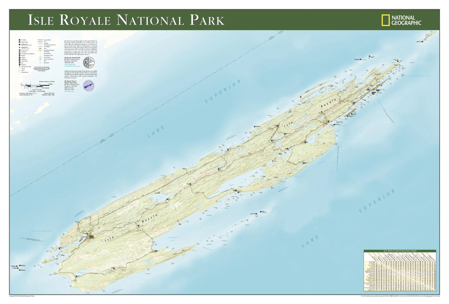
A beautifully detailed map of one of America’s most remote national parks, Isle Royale National Park captures the rugged wilderness of this Lake Superior island in striking topographic clarity. Published by National Geographic and based on the trusted Trails Illustrated series, this wall map combines precision mapping with practical trail information.
Whether you’re planning a hike or remembering a journey, it offers a rich, immersive view of Isle Royale National Park—a place defined by isolation, water, and wild beauty.
Why This Map Stands Out
Detailed topographic mapping
Contours and shaded relief reveal the island’s rugged terrain and elevation.
Built for hikers and explorers
Includes updated trails, routes, and access points.
Trails Illustrated heritage
Trusted cartography used by outdoor enthusiasts worldwide.
A striking poster format
Designed for easy framing and display.
A lasting keepsake
Perfect for those who have experienced—or dream of exploring—Isle Royale.
🗺️ What the Map Shows
- The full extent of Isle Royale National Park within Lake Superior
- Detailed topography, including ridgelines, valleys, and shoreline features
- Hiking trails and backcountry routes across the island
- Campsites, docks, and key visitor locations
- Lakes, waterways, and coastal detail
- A clear view of one of North America’s most remote wilderness areas
📐 Size & Format
914 mm (W) × 610 mm (H)
Landscape orientation
A large, easy-to-read format ideal for:
- Trip planning and route visualisation
- Home offices and outdoor-themed interiors
- Classrooms and geography departments
- Feature walls celebrating wilderness landscapes
✨ Premium Finishes
| Format | Description |
|---|---|
| 📜 Paper (160 gsm) | Heavyweight matte-coated paper—ideal for framing. Preserves fine topographic detail. |
| 🧼 Laminated (Encapsulated) | Sealed in 2 × 80-micron gloss laminate. Durable, wipe-clean, and perfect for planning use. |
| 🪵 Laminated + Timber Hang Rails | Laminated map mounted with lacquered natural timber rails and hanging cord—ready to display. |
| 🖼️ Canvas (395 gsm HP Professional Matte) | Printed with archival pigment inks. Enhances depth and terrain clarity. |
| 🪵 Canvas + Timber Hang Rails | Canvas paired with timber rails for a refined, gallery-style presentation. |
🔨 Please allow up to 10 working days for professionally mounted hang-railed finishes.
📊 Specifications
| Feature | Detail |
|---|---|
| Title | Isle Royale National Park |
| Publisher | National Geographic |
| Published | 2007 |
| Scale | 1:83,742 |
| Dimensions | 914 mm × 610 mm |
| Orientation | Landscape |
| Map Type | Topographic / Physical |
| Coverage | Isle Royale National Park, Michigan, USA |
| Collections | USA, Topographic, Physical |
| Materials | 160 gsm matte paper / 2 × 80-micron laminate / 395 gsm HP Professional Matte Canvas |
| Printing | Pigment-based, fade-resistant inks |
| Origin | Printed in Australia |
🎯 Ideal For
- Hikers and outdoor enthusiasts exploring Isle Royale
- Students and educators of geography and environmental science
- Collectors of National Geographic topographic maps
- Interiors inspired by wilderness and adventure
- Gift buyers seeking a meaningful outdoor keepsake
🌲 A Wilderness Apart
Isle Royale is defined by isolation and natural beauty:
- A remote island park surrounded by Lake Superior
- Dense forests, inland lakes, and rugged shorelines
- Trails winding through untouched wilderness
- A place where nature dominates and solitude prevails
This map captures that experience—offering a detailed view of a landscape where distance, water, and wilderness meet.
🤝 Our Commitment
- Printed in Australia using archival-quality production
- Faithfully reproduced to preserve topographic clarity and detail
- Premium materials selected for durability and long-term display
- Each map is hand-checked before dispatch
- Carefully packaged for safe delivery
🚚 Delivery
- Paper, Laminated, Canvas (rolled): Dispatch within 1–2 business days
- Hang-Railed Maps: Made to order—allow up to 10 working days
- Packaging: Securely rolled in protective tubing
Explore one of America’s most remote national parks—
a map that brings Isle Royale’s wild beauty into sharp focus.
👉 Order now and bring this wilderness island to your wall.
Original: $57.20
-65%$57.20
$20.02Product Information
Product Information
Shipping & Returns
Shipping & Returns
Description
Topographic Wall Map | Trails, Terrain & Lake Superior Wilderness | Large Format (914 × 610 mm) | Premium Finishes
A beautifully detailed map of one of America’s most remote national parks, Isle Royale National Park captures the rugged wilderness of this Lake Superior island in striking topographic clarity. Published by National Geographic and based on the trusted Trails Illustrated series, this wall map combines precision mapping with practical trail information.
Whether you’re planning a hike or remembering a journey, it offers a rich, immersive view of Isle Royale National Park—a place defined by isolation, water, and wild beauty.
Why This Map Stands Out
Detailed topographic mapping
Contours and shaded relief reveal the island’s rugged terrain and elevation.
Built for hikers and explorers
Includes updated trails, routes, and access points.
Trails Illustrated heritage
Trusted cartography used by outdoor enthusiasts worldwide.
A striking poster format
Designed for easy framing and display.
A lasting keepsake
Perfect for those who have experienced—or dream of exploring—Isle Royale.
🗺️ What the Map Shows
- The full extent of Isle Royale National Park within Lake Superior
- Detailed topography, including ridgelines, valleys, and shoreline features
- Hiking trails and backcountry routes across the island
- Campsites, docks, and key visitor locations
- Lakes, waterways, and coastal detail
- A clear view of one of North America’s most remote wilderness areas
📐 Size & Format
914 mm (W) × 610 mm (H)
Landscape orientation
A large, easy-to-read format ideal for:
- Trip planning and route visualisation
- Home offices and outdoor-themed interiors
- Classrooms and geography departments
- Feature walls celebrating wilderness landscapes
✨ Premium Finishes
| Format | Description |
|---|---|
| 📜 Paper (160 gsm) | Heavyweight matte-coated paper—ideal for framing. Preserves fine topographic detail. |
| 🧼 Laminated (Encapsulated) | Sealed in 2 × 80-micron gloss laminate. Durable, wipe-clean, and perfect for planning use. |
| 🪵 Laminated + Timber Hang Rails | Laminated map mounted with lacquered natural timber rails and hanging cord—ready to display. |
| 🖼️ Canvas (395 gsm HP Professional Matte) | Printed with archival pigment inks. Enhances depth and terrain clarity. |
| 🪵 Canvas + Timber Hang Rails | Canvas paired with timber rails for a refined, gallery-style presentation. |
🔨 Please allow up to 10 working days for professionally mounted hang-railed finishes.
📊 Specifications
| Feature | Detail |
|---|---|
| Title | Isle Royale National Park |
| Publisher | National Geographic |
| Published | 2007 |
| Scale | 1:83,742 |
| Dimensions | 914 mm × 610 mm |
| Orientation | Landscape |
| Map Type | Topographic / Physical |
| Coverage | Isle Royale National Park, Michigan, USA |
| Collections | USA, Topographic, Physical |
| Materials | 160 gsm matte paper / 2 × 80-micron laminate / 395 gsm HP Professional Matte Canvas |
| Printing | Pigment-based, fade-resistant inks |
| Origin | Printed in Australia |
🎯 Ideal For
- Hikers and outdoor enthusiasts exploring Isle Royale
- Students and educators of geography and environmental science
- Collectors of National Geographic topographic maps
- Interiors inspired by wilderness and adventure
- Gift buyers seeking a meaningful outdoor keepsake
🌲 A Wilderness Apart
Isle Royale is defined by isolation and natural beauty:
- A remote island park surrounded by Lake Superior
- Dense forests, inland lakes, and rugged shorelines
- Trails winding through untouched wilderness
- A place where nature dominates and solitude prevails
This map captures that experience—offering a detailed view of a landscape where distance, water, and wilderness meet.
🤝 Our Commitment
- Printed in Australia using archival-quality production
- Faithfully reproduced to preserve topographic clarity and detail
- Premium materials selected for durability and long-term display
- Each map is hand-checked before dispatch
- Carefully packaged for safe delivery
🚚 Delivery
- Paper, Laminated, Canvas (rolled): Dispatch within 1–2 business days
- Hang-Railed Maps: Made to order—allow up to 10 working days
- Packaging: Securely rolled in protective tubing
Explore one of America’s most remote national parks—
a map that brings Isle Royale’s wild beauty into sharp focus.
👉 Order now and bring this wilderness island to your wall.


