Italy - Albert van Kampen (1887)
A sweeping classroom vision of the Italian peninsula
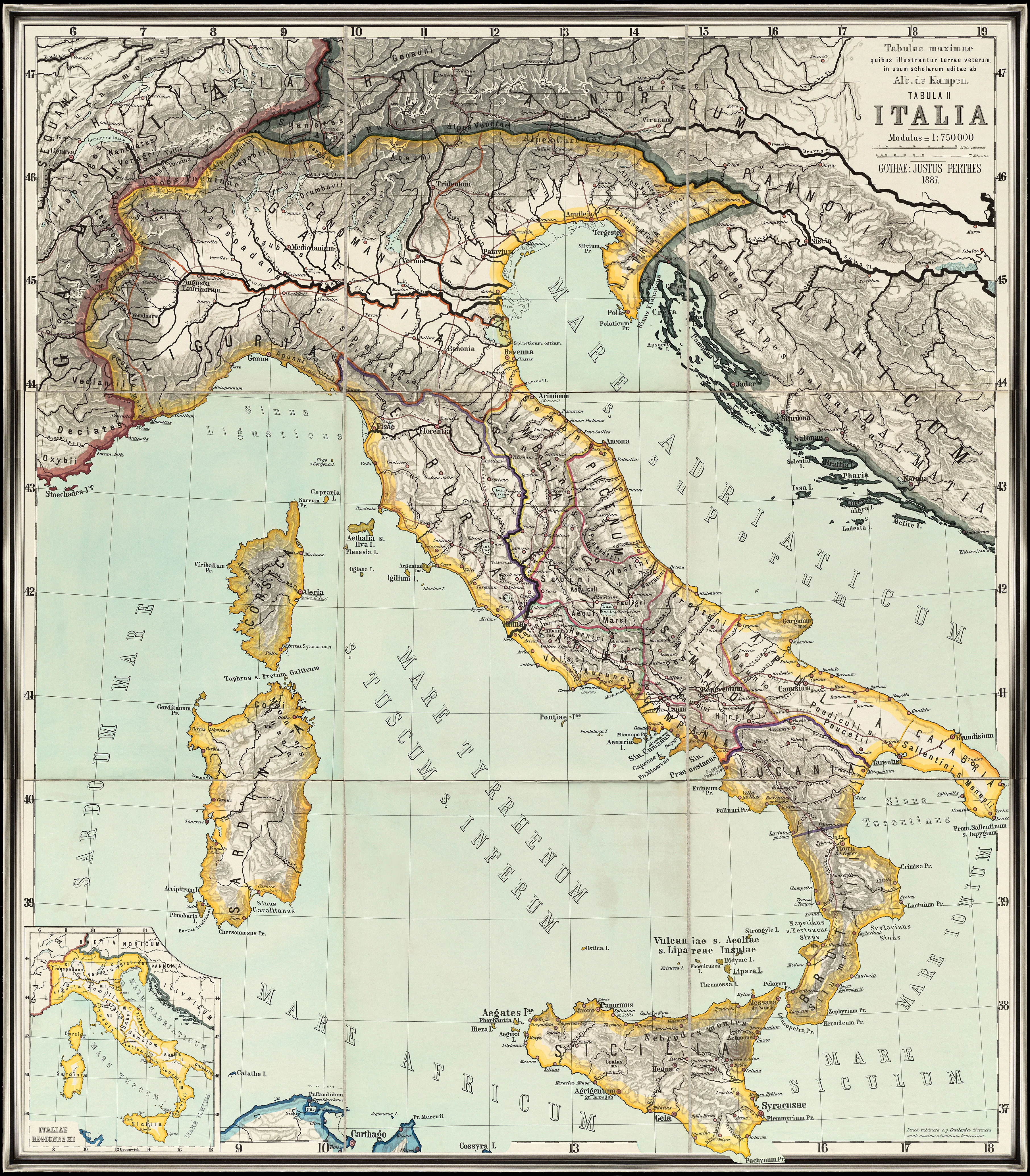
This magnificent 1887 map of Italy by Albert van Kampen captures the country at the moment it was becoming a modern nation, while still deeply rooted in the geography of antiquity. Created as an educational wall map for schools, it presents Italy in rich colour and clear, structured detail — from the snowbound Alps to the sunlit coasts of Sicily.
This is Italy not as a postcard, but as a living geography: mountains, rivers, cities, seas and regions arranged so students could understand how the peninsula shaped the history of Rome, the Renaissance, and the modern Italian state.
This is not just a map.
It is Italy as a civilisation on display.
🇮🇹 What This Map Shows
Designed for classroom walls, this beautifully balanced map presents the Italian peninsula with clarity and elegance.
-
The full Italian peninsula — from the Alps to Sicily and Sardinia
-
Historic regions and provinces as understood in the late 19th century
-
Major cities and ports — Rome, Milan, Venice, Naples, Genoa, Palermo and more
-
Mountain ranges and river systems — Alps, Apennines, Po, Tiber, Arno
-
Coastlines and seas — Adriatic, Tyrrhenian, Ionian and Mediterranean
-
Clear educational labelling for easy wall-scale reading
This is the geography that shaped the Roman Empire, the Renaissance and modern Europe.
🧭 Why This Map Works
Most modern maps show roads.
This one shows why Italy became Italy.
-
Educational heritage — designed for teaching and understanding
-
Historic cartography — Italy as seen in 1887
-
Perfect balance of beauty and clarity
-
Large-format legibility — ideal for wall display
-
Timeless European design — elegant, restrained and informative
People don’t just admire this map — they learn from it.
✨ Premium Finishes
Every Italy — Albert van Kampen (1887) reproduction is printed in Australia using archival methods to preserve the original linework, colour and historic character.
| Format | Description |
|---|---|
| 📜 Paper (160 gsm matte) | Smooth heavyweight archival paper with crisp lines and rich colour. Ideal for framing under glass. |
| 🧼 Laminated (True Encapsulation) | Sealed between 2 × 80-micron gloss laminate for complete edge-to-edge protection. Tear-resistant and wipe-clean. |
| 🖼️ Canvas (395 gsm HP Professional Matte) | Printed on premium HP canvas using pigment-based, fade-resistant inks for a warm, gallery-grade look. |
| 🪵 Laminated + Timber Hang Rails | Laminated print mounted between natural timber rails with hanging cord — ready to hang. Allow up to 10 working days. |
| 🪵 Canvas + Timber Hang Rails | Canvas finished with lacquered natural timber rails for a refined frameless display. Allow up to 10 working days. |
📐 Size
1000 mm (W) × 875 mm (H)
A commanding near-square format that gives Italy’s mountains, coastlines and cities room to breathe — perfect for feature walls and learning spaces.
🎯 Ideal For
-
Italian history and culture lovers
-
Schools and universities
-
Libraries and heritage spaces
-
Travel and architecture enthusiasts
-
Home studies and elegant interiors
🤝 Our Commitment
-
Printed in Australia with professional colour management
-
Archival pigment inks for long-term stability
-
Premium laminates and canvas for durability
-
Natural timber hang rails for elegant presentation
-
Hand-checked and carefully packed before dispatch
From the Alps to Sicily, Italy’s story is written in its geography.
Choose your finish and let this classic 1887 map bring Italy’s past and present to life on your wall.


