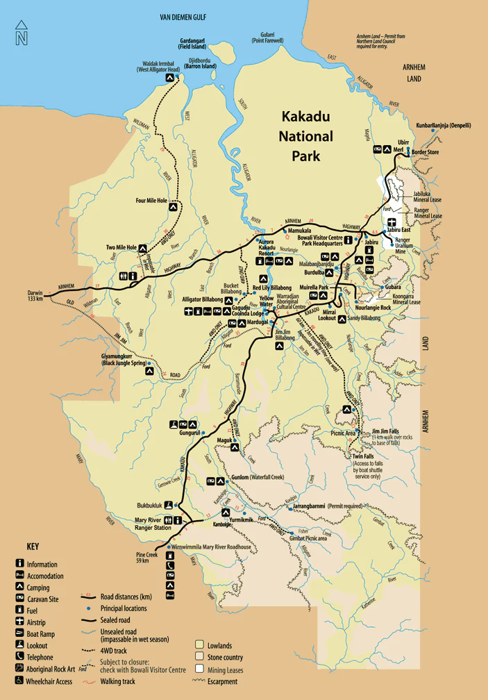
Kakadu National Park Wall Map
Kakadu National Park Wall Map — 1000 × 700 mm
UNESCO World Heritage | Australia’s Largest National Park | Premium Finishes
Trace the sweep of stone escarpments, floodplains, and monsoon forests with a beautifully detailed wall map of Kakadu National Park—Australia’s largest national park and a dual-listed UNESCO World Heritage landscape for both natural and cultural values. From the thundering falls of the wet to the mirror-still billabongs of the dry, Kakadu is a living mosaic of habitats, wildlife, and ancient story.
🗺️ Why this map captivates
-
Iconic landscapes at a glance — Arnhem Land escarpment, sandstone plateaus, floodplains, wetlands, and tidal flats.
-
Seasonal sense-making — Understand wet/dry transitions with clearly rendered rivers, creeks, and billabongs.
-
Wildlife context — Habitats for over 280 bird species, estuarine crocodiles, wallabies, and more, shown through terrain and water networks.
-
Visitor-ready orientation — Major access routes, park gates, key localities, major waterways, and notable lookouts marked for planning.
-
Cultural significance — Context for renowned Aboriginal rock art sites and cultural landscapes that speak to 65,000+ years of continuous care.
Cultural respect: Kakadu is home to the Bininj and Mungguy people. Visitors are encouraged to follow local guidance on access, photography, and cultural protocol.
🔎 What you’ll see on the map
-
Topography & relief shading for quick interpretation of escarpments and plateaus.
-
Hydrology — rivers, creeks, floodplains, wetlands, and major billabongs.
-
Key localities & tracks — primary roads, notable trailheads, boat-cruise corridors, and major lookouts (where applicable).
-
Conservation context — national park boundaries and surrounding protected areas for trip planning.
-
Clear, wall-readable labelling optimised for mid-to-large rooms.
(Cartographic content is optimised for wall display and trip overview; always refer to current park notices and official visitor information when travelling.)
✨ Premium finishes (choose your display)
| Format | Description |
|---|---|
| 📜 Paper (160 gsm matte) | Archival, smooth matte—ideal for framing under glass. |
| 🧼 Laminated (True Encapsulation) | 2 × 80-micron gloss laminate, edge-sealed—durable, wipe-clean, planning-friendly. |
| 🖼️ Canvas (395 gsm HP Professional Matte) | Textured, gallery-grade; printed with pigment-based, fade-resistant inks. |
| 🪵 Laminated + Timber Hang Rails | Natural timber rails (top/bottom) with fitted cord—ready to hang. Allow up to 10 working days. |
| 🪵 Canvas + Timber Hang Rails | Canvas finished with lacquered natural timber rails—frameless elegance. Allow up to 10 working days. |
📐 Specifications
| Feature | Detail |
|---|---|
| Title | Kakadu National Park Wall Map |
| Region | Northern Territory, Australia |
| Dimensions | 1000 mm (W) × 700 mm (H) |
| Map Type | Physical / Visitor overview |
| Finishes | Paper (160 gsm), Laminated (2 × 80-micron gloss), Canvas (395 gsm), optional timber hang rails |
| Printing | Archival pigment inks for long-term colour stability |
| Origin | Printed in Australia |
🎯 Who it’s for
-
Travellers & families planning a first or return journey to Kakadu.
-
Educators & guides needing a clear wall reference for interpretation.
-
Design-led interiors seeking an Australian statement piece.
-
Conservation & tourism operators for reception, briefing, or lodge spaces.
🤝 Our Commitment
-
Local craftsmanship: Designed, printed, and finished in Australia.
-
Premium materials: Archival HP pigment inks, professional laminates, natural timber rails.
-
Colour-managed clarity: Wall-readable labelling and consistent cartography at statement scale.
-
Built to last: Durable finishes to extend service life and reduce waste.
-
Packed with care: Every map is hand-checked and shipped to arrive clean and display-ready.
🚚 Shipping & lead time
-
Paper / Laminated / Canvas (rolled): Usually ships within 1–2 business days.
-
Hang-railed maps: Custom mounted—please allow up to 10 working days.
Bring Australia’s most storied landscape to your wall—a daily invitation to explore Kakadu’s stone country, wetlands, and ancient cultural heart.
Add to cart and start planning your next Top End adventure.
Original: $42.89
-65%$42.89
$15.01Product Information
Product Information
Shipping & Returns
Shipping & Returns
Description
Kakadu National Park Wall Map — 1000 × 700 mm
UNESCO World Heritage | Australia’s Largest National Park | Premium Finishes
Trace the sweep of stone escarpments, floodplains, and monsoon forests with a beautifully detailed wall map of Kakadu National Park—Australia’s largest national park and a dual-listed UNESCO World Heritage landscape for both natural and cultural values. From the thundering falls of the wet to the mirror-still billabongs of the dry, Kakadu is a living mosaic of habitats, wildlife, and ancient story.
🗺️ Why this map captivates
-
Iconic landscapes at a glance — Arnhem Land escarpment, sandstone plateaus, floodplains, wetlands, and tidal flats.
-
Seasonal sense-making — Understand wet/dry transitions with clearly rendered rivers, creeks, and billabongs.
-
Wildlife context — Habitats for over 280 bird species, estuarine crocodiles, wallabies, and more, shown through terrain and water networks.
-
Visitor-ready orientation — Major access routes, park gates, key localities, major waterways, and notable lookouts marked for planning.
-
Cultural significance — Context for renowned Aboriginal rock art sites and cultural landscapes that speak to 65,000+ years of continuous care.
Cultural respect: Kakadu is home to the Bininj and Mungguy people. Visitors are encouraged to follow local guidance on access, photography, and cultural protocol.
🔎 What you’ll see on the map
-
Topography & relief shading for quick interpretation of escarpments and plateaus.
-
Hydrology — rivers, creeks, floodplains, wetlands, and major billabongs.
-
Key localities & tracks — primary roads, notable trailheads, boat-cruise corridors, and major lookouts (where applicable).
-
Conservation context — national park boundaries and surrounding protected areas for trip planning.
-
Clear, wall-readable labelling optimised for mid-to-large rooms.
(Cartographic content is optimised for wall display and trip overview; always refer to current park notices and official visitor information when travelling.)
✨ Premium finishes (choose your display)
| Format | Description |
|---|---|
| 📜 Paper (160 gsm matte) | Archival, smooth matte—ideal for framing under glass. |
| 🧼 Laminated (True Encapsulation) | 2 × 80-micron gloss laminate, edge-sealed—durable, wipe-clean, planning-friendly. |
| 🖼️ Canvas (395 gsm HP Professional Matte) | Textured, gallery-grade; printed with pigment-based, fade-resistant inks. |
| 🪵 Laminated + Timber Hang Rails | Natural timber rails (top/bottom) with fitted cord—ready to hang. Allow up to 10 working days. |
| 🪵 Canvas + Timber Hang Rails | Canvas finished with lacquered natural timber rails—frameless elegance. Allow up to 10 working days. |
📐 Specifications
| Feature | Detail |
|---|---|
| Title | Kakadu National Park Wall Map |
| Region | Northern Territory, Australia |
| Dimensions | 1000 mm (W) × 700 mm (H) |
| Map Type | Physical / Visitor overview |
| Finishes | Paper (160 gsm), Laminated (2 × 80-micron gloss), Canvas (395 gsm), optional timber hang rails |
| Printing | Archival pigment inks for long-term colour stability |
| Origin | Printed in Australia |
🎯 Who it’s for
-
Travellers & families planning a first or return journey to Kakadu.
-
Educators & guides needing a clear wall reference for interpretation.
-
Design-led interiors seeking an Australian statement piece.
-
Conservation & tourism operators for reception, briefing, or lodge spaces.
🤝 Our Commitment
-
Local craftsmanship: Designed, printed, and finished in Australia.
-
Premium materials: Archival HP pigment inks, professional laminates, natural timber rails.
-
Colour-managed clarity: Wall-readable labelling and consistent cartography at statement scale.
-
Built to last: Durable finishes to extend service life and reduce waste.
-
Packed with care: Every map is hand-checked and shipped to arrive clean and display-ready.
🚚 Shipping & lead time
-
Paper / Laminated / Canvas (rolled): Usually ships within 1–2 business days.
-
Hang-railed maps: Custom mounted—please allow up to 10 working days.
Bring Australia’s most storied landscape to your wall—a daily invitation to explore Kakadu’s stone country, wetlands, and ancient cultural heart.
Add to cart and start planning your next Top End adventure.