Large-Format | Street-Level Detail | Premium Finishes
Bring the energy of central Kolkata to your wall with a highly legible, street-scale map built for clarity, planning, and display. The Kolkata City Wall Map presents the complete road network, rail & commuter corridors, land-use patterns, and points of interest in a clean, visually balanced layout—ideal for business operations, service & delivery planning, classrooms, and refined city memorabilia.
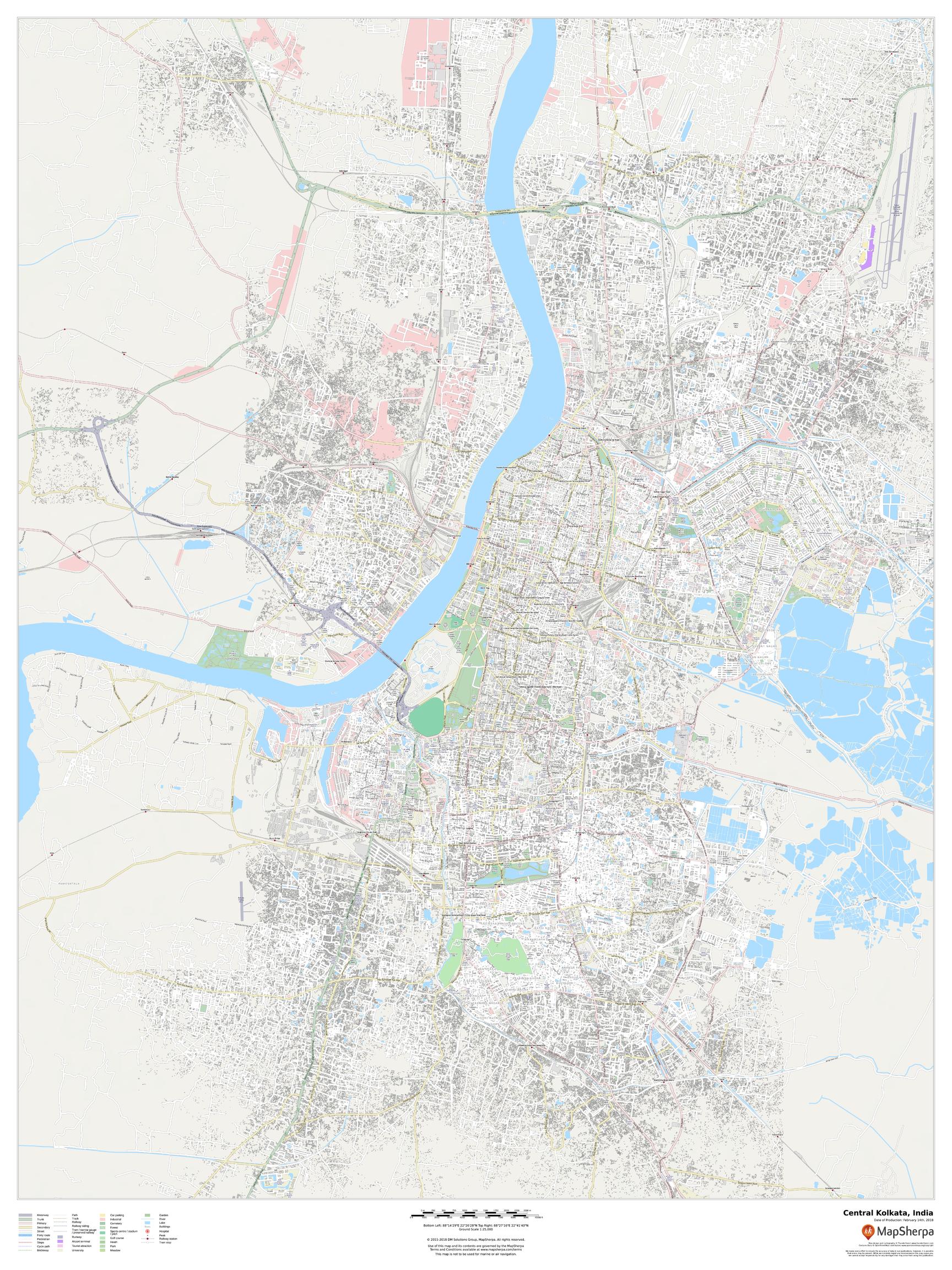
🗺️ Map Features (Expanded)
-
Street-Level Clarity: Thorough street labelling supports routing, sales territories, and service coverage at a glance.
-
Transport Context: Rail lines, corridors, stations, and major arterials shown together for quick multimodal understanding.
-
Land Use & Urban Fabric: Parks, campuses, riverfronts, industrial zones, and civic precincts rendered with intuitive symbology.
-
Points of Interest: Landmarks, markets, cultural venues, hospitals, universities, and transit nodes clearly identified.
-
River & Waterfront Readability: The urban relationship with waterways is expressed to explain movement and settlement patterns.
-
Wall-Optimised Design: Disciplined label hierarchy, crisp typography, and a tidy legend ensure excellent legibility across meeting rooms and studios.
-
Planning-Friendly Cartography: Neutral, contrast-forward palette prevents visual clutter while preserving fine detail at 1:25,000.
🧭 Who It’s For
-
Operations & Logistics: Branch catchments, crew routing, and service zones.
-
Retail & Real Estate: Site selection, competitor proximity, and neighbourhood context.
-
Education: Urban geography, transport systems, and land-use studies.
-
Design & Décor: A sophisticated focal piece for offices, libraries, and studios.
✨ Available Finishes
| Format | Description |
|---|---|
| 📜 Paper (160 gsm) | Heavyweight matte-coated paper—perfect for framing under glass. |
| 🧼 Laminated (Encapsulated) | Fully sealed in 80-micron gloss laminate for a durable, wipe-clean surface—great for high-use spaces. |
| 🪵 Laminated with Wooden Hang Rails | Laminated map mounted with lacquered natural timber rails (top & bottom) and a hanging cord—ready to display. |
| 🖼️ Canvas (395 gsm) | Printed on HP Professional Matte Canvas with archival pigment-based inks—rich texture, fade-resistant, gallery quality. |
| 🪵 Canvas with Wooden Hang Rails | Canvas finished with lacquered timber rails and hanging cord—no framing required for a refined, timeless look. |
🔨 Hang-railed maps are made to order—please allow up to 10 working days for professional mounting.
📐 Specifications
| Feature | Detail |
|---|---|
| Title | Kolkata City Wall Map |
| Map Type | City / Street Map |
| Scale | 1:25,000 |
| Dimensions | 1219 mm (W) × 914 mm (H) |
| Orientation | Landscape |
| Materials | Paper, Laminated, Canvas, With or Without Timber Rails |
| Printing | Pigment-based inks, fade-resistant |
💡 Why You’ll Love This Map
-
Street-scale precision for real-world planning and navigation.
-
Multilayer context—transport, land use, and POIs on one clear canvas.
-
Display-ready design that reads beautifully from a distance.
-
Premium finishes tailored to classrooms, operations hubs, and elegant interiors.
-
A sophisticated way to celebrate Kolkata while gaining practical insight.
🚚 Delivery
-
Paper, Laminated, and Canvas (rolled): Usually ships within 1–2 business days.
-
Hang-railed versions: Made to order; allow up to 10 working days.
-
Packaging: Secure, protective materials to ensure pristine arrival.
Make Kolkata’s streets, networks, and landmarks instantly understandable—on a map that looks as good as it works.
👉 Choose your finish and add to cart today.


