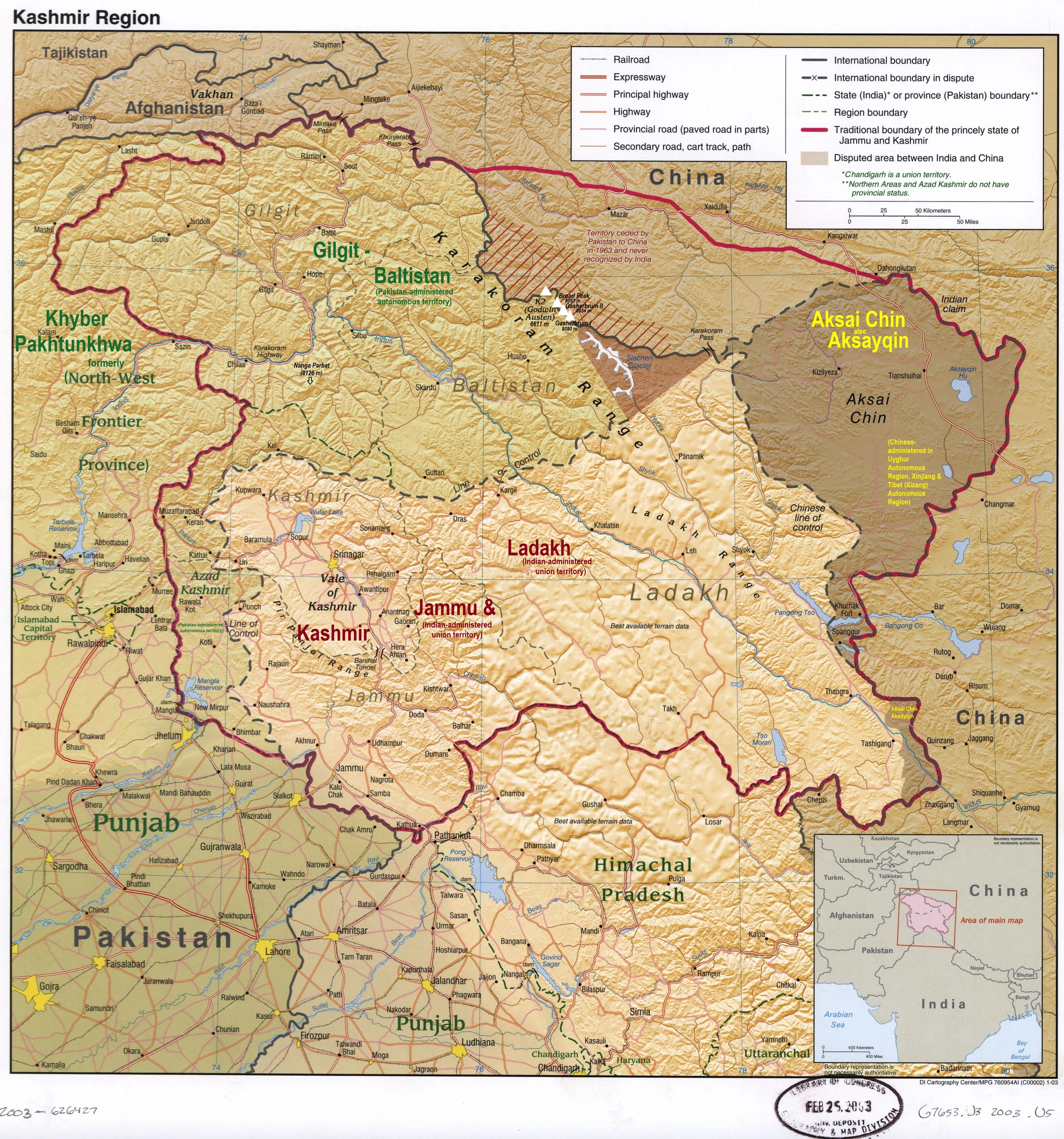
Ladakh Wall Map
Kashmir • Ladakh • Aksai Chin | Political & Physical Context | Premium Finishes
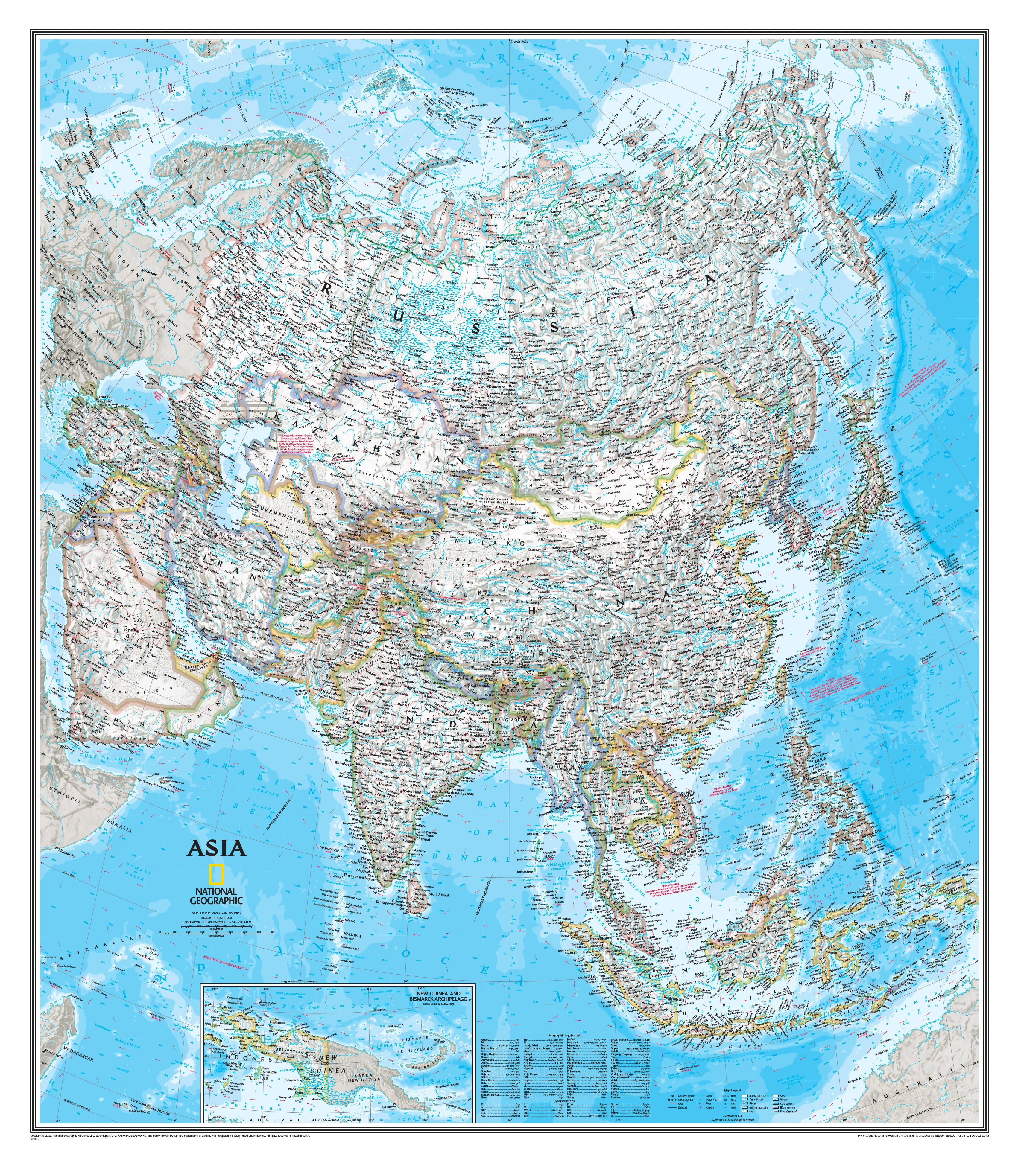
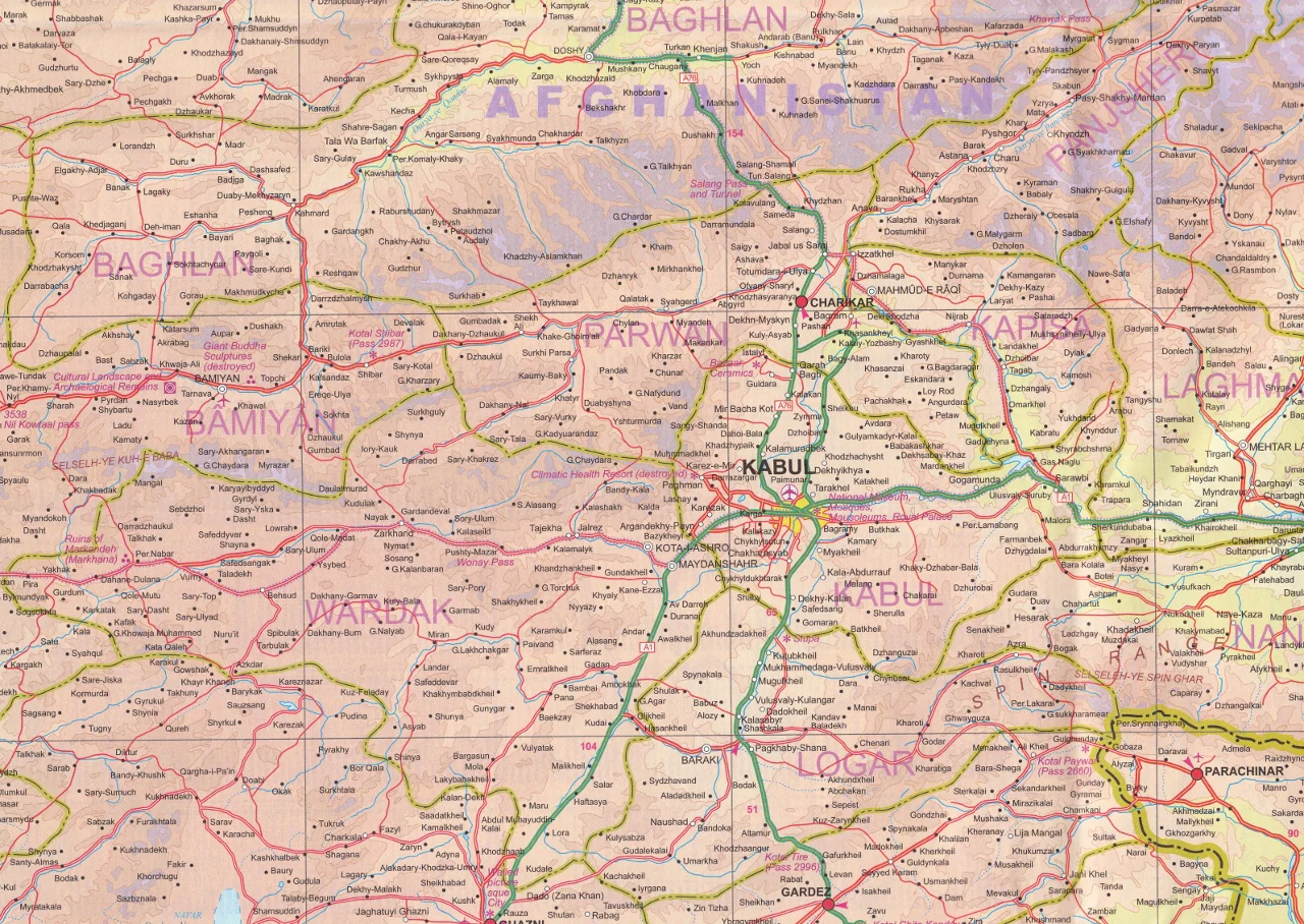
A striking, detailed wall map of one of the world’s most dramatic and least easily understood regions. This Kashmir–Ladakh map presents a clear, neutral visual overview of a landscape defined by high mountains, remote plateaus, and complex territorial realities. Beautiful to display and deeply informative to study, it is an exceptional reference for anyone wanting a clearer geographic understanding of this extraordinary part of Asia.
By distinguishing areas administered by India, Pakistan, and China, the map helps readers quickly grasp how the wider region is organised and contested. Key areas such as Kashmir, Ladakh, and Aksai Chin are shown with the clarity that only a well-designed map can provide—something text alone rarely achieves.
🗺️ Why This Map Matters
-
Clear regional overview
Understand the wider Kashmir–Ladakh region at a glance, with political and physical geography shown together in one coherent view. -
Complex boundaries made readable
The map helps explain difficult geopolitical realities by showing important dividing lines, including the Line of Control (LoC) and Line of Actual Control (LAC). -
Physical landscape in context
Mountain ranges, plateaus, valleys, and key terrain features provide the geographic setting behind the region’s history and strategic importance. -
Educational value
A practical visual reference for students, researchers, teachers, and anyone seeking a more grounded understanding of the area. -
A beautiful wall piece
Beyond its usefulness, this is a compelling map of a remote and visually powerful region—ideal for studies, libraries, offices, and map collections.
🌏 What the Map Shows
-
Kashmir, Ladakh, and Aksai Chin clearly distinguished
-
Administrative and territorial divisions involving India, Pakistan, and China
-
Key political boundary lines such as the LoC and LAC
-
Physical geography that helps explain regional relationships and conflict zones
-
A balanced visual treatment that supports learning and interpretation
✨ Available Finishes
| Format | Description |
|---|---|
| 📜 Paper (160 gsm) | Heavyweight matte-coated paper—perfect for framing under glass. |
| 🧼 Laminated (Encapsulated) | Fully sealed in 80-micron gloss laminate for a durable, wipe-clean surface. |
| 🪵 Laminated with Wooden Hang Rails | Laminated map mounted with lacquered natural timber rails (top & bottom) and a hanging cord—ready to display. |
| 🖼️ Canvas (395 gsm) | HP Professional Matte Canvas with archival pigment inks—rich texture, fade-resistant, gallery quality. |
| 🪵 Canvas with Wooden Hang Rails | Canvas mounted with timber rails and hanging cord—timeless, ready-to-display finish. |
🔨 Note: Hang-railed maps are professionally mounted—please allow up to 10 working days.
📐 Specifications
| Feature | Detail |
|---|---|
| Title | Ladakh Wall Map |
| Coverage | Kashmir, Ladakh, Aksai Chin and surrounding region |
| Map Type | Political / Physical Reference |
| Dimensions | 950 mm (W) × 950 mm (H) |
| Orientation | Square |
| Materials | Paper, Laminated, Canvas, with or without Timber Rails |
| Printing | Pigment-based, fade-resistant inks |
| Made In | Australia |
🎁 Perfect For
-
Students and educators studying Asian geography, politics, and modern history
-
Researchers and analysts needing a clear wall reference
-
Collectors of regional and geopolitical maps
-
Home and office décor with intellectual depth and visual presence
-
Gift-giving for map lovers and serious travellers
🤝 Our Commitment
-
Local craftsmanship: Designed, printed, and finished in Australia.
-
Premium materials: Archival HP pigment inks, professional laminates, natural timber rails.
-
Colour-managed clarity: Wall-readable labelling and consistent cartography at large format.
-
Built to last: Durable finishes to extend service life and reduce waste.
-
Packed with care: Every map is hand-checked and shipped to arrive clean and display-ready.
🚚 Delivery
-
Paper, Laminated, Canvas (rolled): Typically ship within 1–2 business days
-
Hang-Railed Maps: Made to order—please allow up to 10 working days
-
Protective Packaging: Securely packed to arrive in pristine condition
Bring the landscapes, boundaries, and complexity of Ladakh and the wider Kashmir region into sharper focus with a map that is both beautifully presented and genuinely informative.
Product Information
Product Information
Shipping & Returns
Shipping & Returns
Description
Kashmir • Ladakh • Aksai Chin | Political & Physical Context | Premium Finishes
A striking, detailed wall map of one of the world’s most dramatic and least easily understood regions. This Kashmir–Ladakh map presents a clear, neutral visual overview of a landscape defined by high mountains, remote plateaus, and complex territorial realities. Beautiful to display and deeply informative to study, it is an exceptional reference for anyone wanting a clearer geographic understanding of this extraordinary part of Asia.
By distinguishing areas administered by India, Pakistan, and China, the map helps readers quickly grasp how the wider region is organised and contested. Key areas such as Kashmir, Ladakh, and Aksai Chin are shown with the clarity that only a well-designed map can provide—something text alone rarely achieves.
🗺️ Why This Map Matters
-
Clear regional overview
Understand the wider Kashmir–Ladakh region at a glance, with political and physical geography shown together in one coherent view. -
Complex boundaries made readable
The map helps explain difficult geopolitical realities by showing important dividing lines, including the Line of Control (LoC) and Line of Actual Control (LAC). -
Physical landscape in context
Mountain ranges, plateaus, valleys, and key terrain features provide the geographic setting behind the region’s history and strategic importance. -
Educational value
A practical visual reference for students, researchers, teachers, and anyone seeking a more grounded understanding of the area. -
A beautiful wall piece
Beyond its usefulness, this is a compelling map of a remote and visually powerful region—ideal for studies, libraries, offices, and map collections.
🌏 What the Map Shows
-
Kashmir, Ladakh, and Aksai Chin clearly distinguished
-
Administrative and territorial divisions involving India, Pakistan, and China
-
Key political boundary lines such as the LoC and LAC
-
Physical geography that helps explain regional relationships and conflict zones
-
A balanced visual treatment that supports learning and interpretation
✨ Available Finishes
| Format | Description |
|---|---|
| 📜 Paper (160 gsm) | Heavyweight matte-coated paper—perfect for framing under glass. |
| 🧼 Laminated (Encapsulated) | Fully sealed in 80-micron gloss laminate for a durable, wipe-clean surface. |
| 🪵 Laminated with Wooden Hang Rails | Laminated map mounted with lacquered natural timber rails (top & bottom) and a hanging cord—ready to display. |
| 🖼️ Canvas (395 gsm) | HP Professional Matte Canvas with archival pigment inks—rich texture, fade-resistant, gallery quality. |
| 🪵 Canvas with Wooden Hang Rails | Canvas mounted with timber rails and hanging cord—timeless, ready-to-display finish. |
🔨 Note: Hang-railed maps are professionally mounted—please allow up to 10 working days.
📐 Specifications
| Feature | Detail |
|---|---|
| Title | Ladakh Wall Map |
| Coverage | Kashmir, Ladakh, Aksai Chin and surrounding region |
| Map Type | Political / Physical Reference |
| Dimensions | 950 mm (W) × 950 mm (H) |
| Orientation | Square |
| Materials | Paper, Laminated, Canvas, with or without Timber Rails |
| Printing | Pigment-based, fade-resistant inks |
| Made In | Australia |
🎁 Perfect For
-
Students and educators studying Asian geography, politics, and modern history
-
Researchers and analysts needing a clear wall reference
-
Collectors of regional and geopolitical maps
-
Home and office décor with intellectual depth and visual presence
-
Gift-giving for map lovers and serious travellers
🤝 Our Commitment
-
Local craftsmanship: Designed, printed, and finished in Australia.
-
Premium materials: Archival HP pigment inks, professional laminates, natural timber rails.
-
Colour-managed clarity: Wall-readable labelling and consistent cartography at large format.
-
Built to last: Durable finishes to extend service life and reduce waste.
-
Packed with care: Every map is hand-checked and shipped to arrive clean and display-ready.
🚚 Delivery
-
Paper, Laminated, Canvas (rolled): Typically ship within 1–2 business days
-
Hang-Railed Maps: Made to order—please allow up to 10 working days
-
Protective Packaging: Securely packed to arrive in pristine condition
Bring the landscapes, boundaries, and complexity of Ladakh and the wider Kashmir region into sharper focus with a map that is both beautifully presented and genuinely informative.