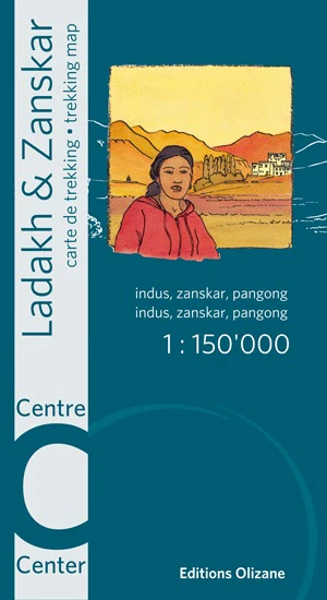
Ladakh & Zanskar Central Olizane Specialist Folded Map
Leh • Padum • Pangong Lake • Scale 1:150,000 • Waterproof Polyart
The Ladakh & Zanskar Central Specialist Map by Éditions Olizane provides detailed coverage of the heart of Ladakh, one of the most extraordinary high-mountain regions on Earth. Focused on the area surrounding Leh, this map stretches from Padum in the west to Pangong Lake in the east, revealing the valleys, mountain passes, monasteries, and remote settlements that define the central Himalaya.
Designed for travellers, trekkers, cyclists, and expedition planners, the map combines modern satellite imagery with field-verified information to create an accurate and highly readable regional map. At a scale of 1:150,000, it offers an ideal balance between overview and practical detail — perfect for understanding the geography of Ladakh while travelling through the region.
Printed on water- and tear-resistant Polyart synthetic paper, the map is built to withstand the realities of Himalayan travel: dust, wind, rain, and constant folding. It is lightweight enough to carry on extended journeys while remaining strong enough for repeated use in the field.
🗺️ Coverage of Central Ladakh & Zanskar
This map focuses on the central sector of the Ladakh–Zanskar region, an area famous for its high passes, ancient monasteries, dramatic landscapes, and remote trekking routes.
Coverage includes:
-
Leh and the central Indus Valley
-
Padum and the Zanskar Valley
-
Pangong Lake and eastern Ladakh
-
Remote valleys and mountain passes
-
High-altitude plateaus and river systems
These areas are among the most travelled parts of Ladakh for adventurers, yet they remain remote and geographically complex. The map provides an excellent overview for navigating between valleys and understanding the wider terrain.
🧭 Detailed Cartography
The map is produced from satellite imagery combined with recent field information, ensuring accuracy and clarity even in remote mountain regions where mapping can be challenging.
Key cartographic features include:
-
Contour lines to illustrate elevation and terrain structure
-
Shaded relief for quick visual understanding of mountains and valleys
-
Villages and settlements throughout Ladakh and Zanskar
-
Monasteries, gompas and cultural sites
-
Roads, jeep tracks and trekking routes
-
Bridges and river crossings
-
Mountain passes and major valleys
-
Sites of tourist and historical interest
These features allow travellers to interpret the landscape easily and plan journeys through one of the most rugged environments in Asia.
🏔 Understanding the Landscape
Ladakh is often described as “Little Tibet”, a high-altitude desert surrounded by some of the world’s tallest mountains. The terrain is characterised by:
-
Deep river valleys carved by the Indus and Zanskar rivers
-
High plateaus rising above 4,000 metres
-
Dramatic mountain passes connecting remote valleys
-
Monasteries perched on cliffs and ridges
-
Villages clustered along rivers and irrigated terraces
A map such as this is invaluable for appreciating how these features connect across the region.
📍 GPS-Compatible Navigation
The map includes coordinate references compatible with GPS devices, enabling travellers to combine traditional navigation with modern digital tools.
This allows users to:
-
Cross-reference locations with handheld GPS units
-
Identify exact positions of passes, villages, and monasteries
-
Plan routes using both digital and printed mapping
For remote travel where connectivity is limited, this hybrid approach is extremely valuable.
⚠️ Border Awareness & Restricted Areas
Parts of Ladakh lie close to sensitive international border regions with China, and some valleys are subject to travel restrictions or permits.
This map clearly marks:
-
Military checkpoints
-
Restricted access valleys
-
Border proximity zones
These details help travellers plan routes responsibly and avoid areas where access may not be permitted.
💪 Built for Expedition Use
Unlike ordinary paper maps, this edition is printed on Polyart synthetic paper, specifically designed for outdoor environments.
Advantages include:
-
Water-resistant — handles rain and snow easily
-
Tear-resistant — far stronger than traditional paper maps
-
Lightweight — ideal for trekking and travel packs
-
Durable under repeated folding
These qualities make the map especially suited for trekking, cycling expeditions, and remote travel.
🗺️ Part of the Olizane Ladakh Map Series
The Olizane Ladakh maps are widely regarded as some of the best trekking maps available for the region. The full series includes three complementary sheets:
-
Ladakh & Zanskar North
-
Ladakh & Zanskar Central
-
Ladakh & Zanskar South
Together they provide comprehensive coverage of Ladakh and Zanskar at 1:150,000 scale, ideal for travellers exploring different parts of the region.
📐 Specifications
| Feature | Detail |
|---|---|
| Title | Ladakh & Zanskar Central |
| Publisher | Éditions Olizane |
| Scale | 1 : 150,000 |
| Coverage | Leh • Padum • Pangong Lake |
| Format | Folded, double-sided trekking map |
| Unfolded Size | 960 × 660 mm |
| Folded Size | 220 × 120 mm |
| Material | Waterproof, tear-resistant Polyart synthetic paper |
| Languages | English / French |
| ISBN / EAN | 978-2880864132 |
| Weight | approx. 59 g |
🎯 Who It’s For
This map is ideal for:
-
Trekkers exploring Ladakh and Zanskar
-
Adventure motorcyclists travelling Himalayan roads
-
Cyclists tackling high mountain passes
-
Expedition planners and tour leaders
-
Travellers visiting monasteries and remote villages
-
Geography enthusiasts fascinated by the Himalaya
📦 Order Information
This map is printed on demand, ensuring the latest edition and production quality.
⏳ Please allow up to 10 working days for delivery.
A trusted navigation companion for the heart of Ladakh — detailed, durable, and designed for travellers exploring one of the most spectacular mountain regions on Earth.
Product Information
Product Information
Shipping & Returns
Shipping & Returns
Description
Leh • Padum • Pangong Lake • Scale 1:150,000 • Waterproof Polyart
The Ladakh & Zanskar Central Specialist Map by Éditions Olizane provides detailed coverage of the heart of Ladakh, one of the most extraordinary high-mountain regions on Earth. Focused on the area surrounding Leh, this map stretches from Padum in the west to Pangong Lake in the east, revealing the valleys, mountain passes, monasteries, and remote settlements that define the central Himalaya.
Designed for travellers, trekkers, cyclists, and expedition planners, the map combines modern satellite imagery with field-verified information to create an accurate and highly readable regional map. At a scale of 1:150,000, it offers an ideal balance between overview and practical detail — perfect for understanding the geography of Ladakh while travelling through the region.
Printed on water- and tear-resistant Polyart synthetic paper, the map is built to withstand the realities of Himalayan travel: dust, wind, rain, and constant folding. It is lightweight enough to carry on extended journeys while remaining strong enough for repeated use in the field.
🗺️ Coverage of Central Ladakh & Zanskar
This map focuses on the central sector of the Ladakh–Zanskar region, an area famous for its high passes, ancient monasteries, dramatic landscapes, and remote trekking routes.
Coverage includes:
-
Leh and the central Indus Valley
-
Padum and the Zanskar Valley
-
Pangong Lake and eastern Ladakh
-
Remote valleys and mountain passes
-
High-altitude plateaus and river systems
These areas are among the most travelled parts of Ladakh for adventurers, yet they remain remote and geographically complex. The map provides an excellent overview for navigating between valleys and understanding the wider terrain.
🧭 Detailed Cartography
The map is produced from satellite imagery combined with recent field information, ensuring accuracy and clarity even in remote mountain regions where mapping can be challenging.
Key cartographic features include:
-
Contour lines to illustrate elevation and terrain structure
-
Shaded relief for quick visual understanding of mountains and valleys
-
Villages and settlements throughout Ladakh and Zanskar
-
Monasteries, gompas and cultural sites
-
Roads, jeep tracks and trekking routes
-
Bridges and river crossings
-
Mountain passes and major valleys
-
Sites of tourist and historical interest
These features allow travellers to interpret the landscape easily and plan journeys through one of the most rugged environments in Asia.
🏔 Understanding the Landscape
Ladakh is often described as “Little Tibet”, a high-altitude desert surrounded by some of the world’s tallest mountains. The terrain is characterised by:
-
Deep river valleys carved by the Indus and Zanskar rivers
-
High plateaus rising above 4,000 metres
-
Dramatic mountain passes connecting remote valleys
-
Monasteries perched on cliffs and ridges
-
Villages clustered along rivers and irrigated terraces
A map such as this is invaluable for appreciating how these features connect across the region.
📍 GPS-Compatible Navigation
The map includes coordinate references compatible with GPS devices, enabling travellers to combine traditional navigation with modern digital tools.
This allows users to:
-
Cross-reference locations with handheld GPS units
-
Identify exact positions of passes, villages, and monasteries
-
Plan routes using both digital and printed mapping
For remote travel where connectivity is limited, this hybrid approach is extremely valuable.
⚠️ Border Awareness & Restricted Areas
Parts of Ladakh lie close to sensitive international border regions with China, and some valleys are subject to travel restrictions or permits.
This map clearly marks:
-
Military checkpoints
-
Restricted access valleys
-
Border proximity zones
These details help travellers plan routes responsibly and avoid areas where access may not be permitted.
💪 Built for Expedition Use
Unlike ordinary paper maps, this edition is printed on Polyart synthetic paper, specifically designed for outdoor environments.
Advantages include:
-
Water-resistant — handles rain and snow easily
-
Tear-resistant — far stronger than traditional paper maps
-
Lightweight — ideal for trekking and travel packs
-
Durable under repeated folding
These qualities make the map especially suited for trekking, cycling expeditions, and remote travel.
🗺️ Part of the Olizane Ladakh Map Series
The Olizane Ladakh maps are widely regarded as some of the best trekking maps available for the region. The full series includes three complementary sheets:
-
Ladakh & Zanskar North
-
Ladakh & Zanskar Central
-
Ladakh & Zanskar South
Together they provide comprehensive coverage of Ladakh and Zanskar at 1:150,000 scale, ideal for travellers exploring different parts of the region.
📐 Specifications
| Feature | Detail |
|---|---|
| Title | Ladakh & Zanskar Central |
| Publisher | Éditions Olizane |
| Scale | 1 : 150,000 |
| Coverage | Leh • Padum • Pangong Lake |
| Format | Folded, double-sided trekking map |
| Unfolded Size | 960 × 660 mm |
| Folded Size | 220 × 120 mm |
| Material | Waterproof, tear-resistant Polyart synthetic paper |
| Languages | English / French |
| ISBN / EAN | 978-2880864132 |
| Weight | approx. 59 g |
🎯 Who It’s For
This map is ideal for:
-
Trekkers exploring Ladakh and Zanskar
-
Adventure motorcyclists travelling Himalayan roads
-
Cyclists tackling high mountain passes
-
Expedition planners and tour leaders
-
Travellers visiting monasteries and remote villages
-
Geography enthusiasts fascinated by the Himalaya
📦 Order Information
This map is printed on demand, ensuring the latest edition and production quality.
⏳ Please allow up to 10 working days for delivery.
A trusted navigation companion for the heart of Ladakh — detailed, durable, and designed for travellers exploring one of the most spectacular mountain regions on Earth.