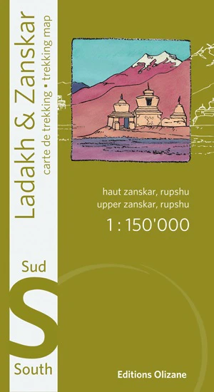
Upper Zanskar • Darsha • Tsomoriri Plateau • Scale 1:150,000 • Waterproof Polyart
For travellers venturing deep into the high Himalaya of Ladakh and Zanskar, reliable mapping is essential. The Ladakh & Zanskar South Specialist Map by Éditions Olizane provides an authoritative overview of this remote and dramatic region, combining modern satellite mapping with traditional cartographic clarity.
Covering Upper Zanskar, Darsha, and the Tsomoriri / Rupshu plateau, this detailed trekking map reveals the intricate network of valleys, high passes, monasteries, and remote settlements that define southern Ladakh. At a scale of 1:150,000, it offers the perfect balance between regional orientation and practical travel detail — ideal for trekkers, expedition travellers, and overland explorers navigating one of the world’s most extraordinary mountain landscapes.
Printed on durable Polyart synthetic paper, the map is built to survive the realities of Himalayan travel — rain, snow, wind, and constant folding — making it far more robust than traditional paper maps.
🗺️ What This Map Shows
This specialist map focuses on the southern sector of the Ladakh–Zanskar region, including many of the areas most frequently visited by trekkers and high-altitude travellers.
Coverage includes:
-
Upper Zanskar Valley
-
Darsha and the access corridor from Himachal Pradesh
-
The Rupshu Plateau
-
Tsomoriri Lake and surrounding high-altitude landscapes
-
Remote Himalayan valleys, mountain passes, and plateau routes
-
Rivers, glaciers, and key natural landmarks
The map provides a clear overview of the terrain across these regions, helping travellers understand valley systems, access routes, and mountain barriers that shape travel in Ladakh.
🧭 Detailed Cartography for Remote Travel
The map has been compiled using satellite imagery and updated field research, resulting in accurate and readable mapping across even the most isolated areas of the region.
Key cartographic features include:
-
Contour lines showing elevation and terrain structure
-
Shaded relief for quick visual interpretation of mountains and valleys
-
Villages and settlements clearly marked
-
Monasteries, gompas, temples and cultural sites
-
Roads, jeep tracks and trekking routes
-
Bridges, river crossings and mountain passes
-
Sites of tourist and cultural interest
This level of detail allows travellers to gain a strong sense of the landscape before and during their journey.
🏔️ Ideal for Trekkers, Cyclists & Expedition Travellers
Ladakh and Zanskar have become some of the most sought-after adventure destinations in the Himalaya. High-altitude trekking routes, remote monasteries, and extraordinary landscapes attract walkers, cyclists, and overland travellers from around the world.
This map is particularly useful for:
-
Trekking and expedition planning
-
Adventure motorcycle routes across Ladakh
-
Cycling journeys across high Himalayan passes
-
Overland travel and route orientation
-
Understanding the geography of the region
For travellers who don’t require extremely detailed trekking maps but want excellent regional orientation, this sheet provides the perfect balance.
📍 GPS-Compatible Navigation
Modern travel often combines traditional navigation with GPS devices. To support this, the map includes:
-
Coordinate references for GPS navigation
-
Accurate geographic positioning for key locations
-
Compatibility with handheld GPS units and mapping apps
This ensures travellers can confidently integrate the map with digital navigation tools.
⚠️ Border Areas & Access Information
Parts of Ladakh lie close to sensitive international borders with China, and some valleys require permits or are subject to access restrictions.
This map identifies:
-
Checkpoints
-
Restricted valleys
-
Border proximity areas
These details are invaluable for travellers planning routes responsibly and avoiding restricted zones.
💪 Built for Real Adventure
Unlike traditional paper maps, this edition is printed on Polyart synthetic paper, specifically chosen for expedition environments.
Benefits include:
-
Water-resistant — withstands rain, snow and moisture
-
Tear-resistant — extremely durable under repeated folding
-
Lightweight — ideal for trekking packs
-
Long-lasting — suitable for extended expeditions
In harsh mountain conditions where ordinary maps quickly fail, Polyart provides dependable performance.
🗺️ Part of the Olizane Ladakh Map Series
This sheet forms part of the three-map Olizane Ladakh–Zanskar specialist series, which together provide comprehensive trekking coverage of the region.
Available companion maps include:
-
Ladakh & Zanskar North
-
Ladakh & Zanskar Centre
-
Ladakh & Zanskar South
Using the three maps together allows travellers to build a complete overview of Ladakh’s mountain geography.
📐 Specifications
| Feature | Detail |
|---|---|
| Title | Ladakh & Zanskar South |
| Publisher | Éditions Olizane |
| Scale | 1 : 150,000 |
| Coverage | Upper Zanskar • Darsha • Tsomoriri • Rupshu Plateau |
| Format | Folded, double-sided map |
| Unfolded Size | approx. 960 × 660 mm |
| Folded Size | approx. 220 × 120 mm |
| Material | Waterproof, tear-resistant Polyart synthetic paper |
| GPS Coordinates | Included |
| Languages | English / French |
| ISBN / EAN | 978-2880864149 |
🎯 Who It’s For
This map is perfect for:
-
Trekkers exploring the Himalaya
-
Adventure motorcyclists crossing Ladakh
-
Cyclists tackling high mountain roads
-
Backcountry travellers and expedition teams
-
Geography enthusiasts fascinated by the Himalaya
📦 Order Information
This map is printed to order, ensuring you receive a fresh, current edition.
⏳ Please allow up to 10 working days for production and delivery.
A trusted Himalayan travel map — clear, durable, and built for serious exploration across Ladakh and Zanskar’s extraordinary high-mountain terrain.