Landscope America: Open Space at Risk by National Geographic
Thematic Conservation Wall Map | Development Pressure, Climate Risk & Land Use | Large Format (1067 × 762 mm) | Premium Finishes
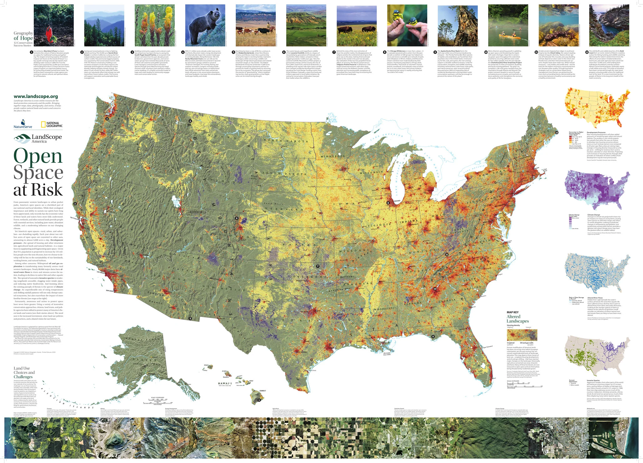
A powerful companion to Natural States of America, Open Space at Risk reveals the mounting pressures facing the United States’ landscapes. Published by National Geographic in 2008, this large-format conservation map highlights the forces reshaping open space—from urban expansion to energy development and environmental change.
Combining data, mapping, and real-world stories, it presents a clear and compelling picture of a nation balancing growth with preservation.
Why This Map Stands Out
A national view of land under pressure
Explores the key threats facing open space across the United States.
Data-rich and visually compelling
Combines maps, infographics, and narrative insights.
Highlights real-world conservation efforts
Features stories of organisations working to protect landscapes.
Focus on future risk
Includes projections and forward-looking environmental challenges.
A striking educational wall map
Large format ideal for both learning and display.
🗺️ What the Map Shows
- Areas of the United States facing development pressure
- Impacts from oil and gas extraction and infrastructure expansion
- Loss of agricultural lands and open countryside
- Inset maps illustrating:
- Projected residential development (2030)
- Regions most vulnerable to climate change
- Altered river systems and water flow impacts
- Spread of invasive species
- Case studies showing how conservation groups are working to protect key areas
📐 Size & Format
1067 mm (W) × 762 mm (H)
Landscape orientation
A large, impactful format ideal for:
- Classrooms and environmental education
- Offices and conservation organisations
- Home studies and workspaces
- Feature walls requiring a meaningful centrepiece
✨ Premium Finishes
| Format | Description |
|---|---|
| 📜 Paper (160 gsm) | Heavyweight matte-coated paper—ideal for framing. Preserves clarity across maps and graphics. |
| 🧼 Laminated (Encapsulated) | Sealed in 2 × 80-micron gloss laminate. Durable, wipe-clean, and suitable for frequent reference. |
| 🪵 Laminated + Timber Hang Rails | Laminated map mounted with lacquered natural timber rails and hanging cord—ready to display. |
| 🖼️ Canvas (395 gsm HP Professional Matte) | Printed with archival pigment inks. Enhances colour depth and visual impact. |
| 🪵 Canvas + Timber Hang Rails | Canvas paired with timber rails for a refined, gallery-style presentation. |
🔨 Please allow up to 10 working days for professionally mounted hang-railed finishes.
📊 Specifications
| Feature | Detail |
|---|---|
| Title | Landscope America: Open Space at Risk |
| Publisher | National Geographic |
| Published | 2008 |
| Scale | 1:5,500,000 |
| Dimensions | 1067 mm × 762 mm |
| Orientation | Landscape |
| Map Type | Thematic / Environmental / Conservation |
| Coverage | United States |
| Collections | USA, Thematic |
| Materials | 160 gsm matte paper / 2 × 80-micron laminate / 395 gsm HP Professional Matte Canvas |
| Printing | Pigment-based, fade-resistant inks |
| Origin | Printed in Australia |
🎯 Ideal For
- Students and educators of environmental science and geography
- Professionals in planning, conservation, and land management
- Organisations focused on sustainability and climate impact
- Collectors of National Geographic thematic maps
- Interiors seeking a thought-provoking, data-rich display
🌎 A Landscape Under Pressure
Across the United States:
- Urban expansion continues to reshape open land
- Natural systems are increasingly affected by climate change
- Agricultural landscapes face ongoing decline
- Conservation efforts must adapt to new and complex challenges
This map captures that urgency—offering a clear view of the forces shaping the future of America’s landscapes.
🤝 Our Commitment
- Printed in Australia using archival-quality production
- Faithfully reproduced to preserve clarity, colour, and data accuracy
- Premium materials selected for durability and long-term display
- Each map is hand-checked before dispatch
- Carefully packaged for safe delivery
🚚 Delivery
- Paper, Laminated, Canvas (rolled): Dispatch within 1–2 business days
- Hang-Railed Maps: Made to order—allow up to 10 working days
- Packaging: Securely rolled in protective tubing
See the pressures shaping tomorrow’s landscapes—
a map that brings risk, resilience, and conservation into focus.
👉 Order now and add a powerful environmental perspective to your wall.
Original: $57.20
-65%$57.20
$20.02Product Information
Product Information
Shipping & Returns
Shipping & Returns
Description
Thematic Conservation Wall Map | Development Pressure, Climate Risk & Land Use | Large Format (1067 × 762 mm) | Premium Finishes
A powerful companion to Natural States of America, Open Space at Risk reveals the mounting pressures facing the United States’ landscapes. Published by National Geographic in 2008, this large-format conservation map highlights the forces reshaping open space—from urban expansion to energy development and environmental change.
Combining data, mapping, and real-world stories, it presents a clear and compelling picture of a nation balancing growth with preservation.
Why This Map Stands Out
A national view of land under pressure
Explores the key threats facing open space across the United States.
Data-rich and visually compelling
Combines maps, infographics, and narrative insights.
Highlights real-world conservation efforts
Features stories of organisations working to protect landscapes.
Focus on future risk
Includes projections and forward-looking environmental challenges.
A striking educational wall map
Large format ideal for both learning and display.
🗺️ What the Map Shows
- Areas of the United States facing development pressure
- Impacts from oil and gas extraction and infrastructure expansion
- Loss of agricultural lands and open countryside
- Inset maps illustrating:
- Projected residential development (2030)
- Regions most vulnerable to climate change
- Altered river systems and water flow impacts
- Spread of invasive species
- Case studies showing how conservation groups are working to protect key areas
📐 Size & Format
1067 mm (W) × 762 mm (H)
Landscape orientation
A large, impactful format ideal for:
- Classrooms and environmental education
- Offices and conservation organisations
- Home studies and workspaces
- Feature walls requiring a meaningful centrepiece
✨ Premium Finishes
| Format | Description |
|---|---|
| 📜 Paper (160 gsm) | Heavyweight matte-coated paper—ideal for framing. Preserves clarity across maps and graphics. |
| 🧼 Laminated (Encapsulated) | Sealed in 2 × 80-micron gloss laminate. Durable, wipe-clean, and suitable for frequent reference. |
| 🪵 Laminated + Timber Hang Rails | Laminated map mounted with lacquered natural timber rails and hanging cord—ready to display. |
| 🖼️ Canvas (395 gsm HP Professional Matte) | Printed with archival pigment inks. Enhances colour depth and visual impact. |
| 🪵 Canvas + Timber Hang Rails | Canvas paired with timber rails for a refined, gallery-style presentation. |
🔨 Please allow up to 10 working days for professionally mounted hang-railed finishes.
📊 Specifications
| Feature | Detail |
|---|---|
| Title | Landscope America: Open Space at Risk |
| Publisher | National Geographic |
| Published | 2008 |
| Scale | 1:5,500,000 |
| Dimensions | 1067 mm × 762 mm |
| Orientation | Landscape |
| Map Type | Thematic / Environmental / Conservation |
| Coverage | United States |
| Collections | USA, Thematic |
| Materials | 160 gsm matte paper / 2 × 80-micron laminate / 395 gsm HP Professional Matte Canvas |
| Printing | Pigment-based, fade-resistant inks |
| Origin | Printed in Australia |
🎯 Ideal For
- Students and educators of environmental science and geography
- Professionals in planning, conservation, and land management
- Organisations focused on sustainability and climate impact
- Collectors of National Geographic thematic maps
- Interiors seeking a thought-provoking, data-rich display
🌎 A Landscape Under Pressure
Across the United States:
- Urban expansion continues to reshape open land
- Natural systems are increasingly affected by climate change
- Agricultural landscapes face ongoing decline
- Conservation efforts must adapt to new and complex challenges
This map captures that urgency—offering a clear view of the forces shaping the future of America’s landscapes.
🤝 Our Commitment
- Printed in Australia using archival-quality production
- Faithfully reproduced to preserve clarity, colour, and data accuracy
- Premium materials selected for durability and long-term display
- Each map is hand-checked before dispatch
- Carefully packaged for safe delivery
🚚 Delivery
- Paper, Laminated, Canvas (rolled): Dispatch within 1–2 business days
- Hang-Railed Maps: Made to order—allow up to 10 working days
- Packaging: Securely rolled in protective tubing
See the pressures shaping tomorrow’s landscapes—
a map that brings risk, resilience, and conservation into focus.
👉 Order now and add a powerful environmental perspective to your wall.


