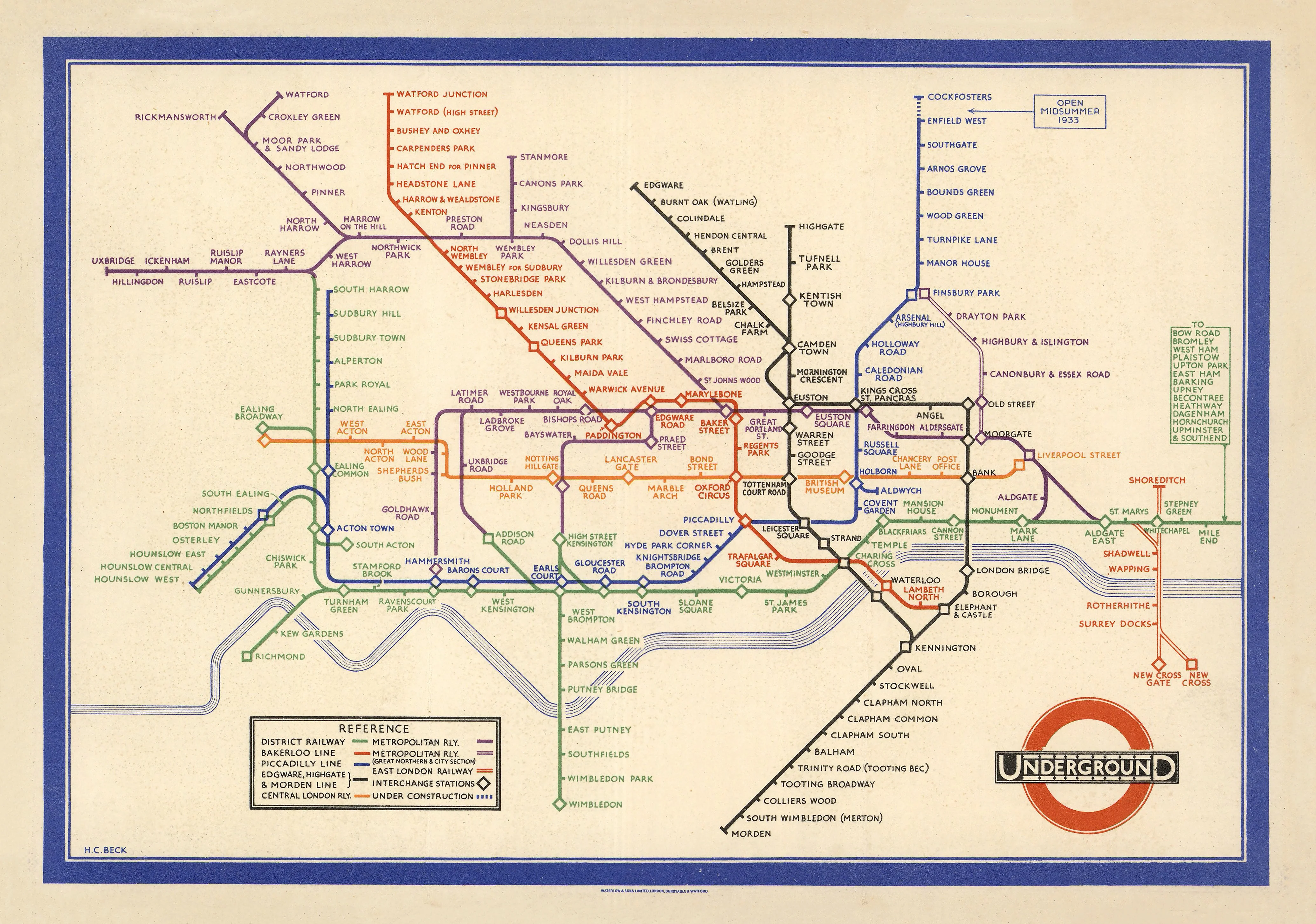
London Underground, designed by Henry Charles Beck (1933)
Icon of Modern Design | First Schematic Transit Map | Premium Wall Format (841 × 595 mm)
A quiet revolution in lines and colour, the 1933 London Underground map by Henry Charles Beck transformed the way the world navigates complex systems. What began as a practical solution for a crowded and confusing rail network became one of the most influential design breakthroughs of the 20th century.
Rather than attempting to mirror real-world geography, Beck reimagined the Underground as a diagram—a network of relationships. Distances were compressed, angles standardised, and clarity elevated above all else. The result was a map that anyone could understand at a glance—a radical idea at the time, and now the global standard.
Originally issued as a small folded leaflet for commuters, this edition has been carefully scaled into a large-format wall map, allowing every line, interchange, and typographic detail to be appreciated as both a functional system and a work of art.
⚓ Why This Map Stands Out
The birth of modern transit mapping
This is the first map to fully embrace a schematic, non-geographic approach—now used in virtually every metro system worldwide.
Clarity through abstraction
By removing unnecessary geographic distortion, Beck made the Underground easier—not harder—to understand.
A designer’s map, not just a navigator’s tool
Its influence extends far beyond transport—into graphic design, UX, data visualisation, and systems thinking.
Enduring visual language
Straight lines, fixed angles, and colour-coded routes create a system that feels intuitive even to first-time users.
From pocket guide to wall statement
Originally just 21 × 15 cm, this enlarged format transforms it into a gallery-worthy centrepiece.
🗺️ What the Map Shows
- The early network of the London Underground as it stood in 1933
- Colour-coded lines including Bakerloo, Piccadilly, District, Metropolitan, and Northern lines
- Major interchanges such as Waterloo, King’s Cross, Liverpool Street, and Paddington
- A fully schematic layout—stations spaced for clarity, not distance
- Clean visual hierarchy prioritising connections, transfers, and flow
Rather than asking “Where is this place?”, the map answers a more important question:
“How do I get there?”
📐 Size & Presence
841 mm (W) × 595 mm (H)
Landscape orientation
This format offers the perfect balance—large enough to appreciate the full design system, yet versatile enough for a wide range of spaces:
- Studios and creative offices
- Home libraries and study walls
- Classrooms and lecture spaces
- Hallways and conversation areas
✨ Premium Finishes
| Format | Description |
|---|---|
| 📜 Paper (160 gsm) | Heavyweight matte-coated paper—ideal for framing. Crisp linework and faithful colour reproduction. |
| 🧼 Laminated (Encapsulated) | Sealed in 2 × 80-micron gloss laminate. Durable, wipe-clean, and perfect for interactive or high-use environments. |
| 🪵 Laminated + Timber Hang Rails | Laminated map mounted with lacquered natural timber rails and hanging cord—ready to display immediately. |
| 🖼️ Canvas (395 gsm HP Professional Matte) | Printed with archival pigment inks. Subtle texture enhances the graphic quality and reduces glare. |
| 🪵 Canvas + Timber Hang Rails | Canvas paired with timber rails for a refined, gallery-style presentation without the need for framing. |
🔨 Please allow up to 10 working days for professionally mounted hang-railed finishes.
📊 Specifications
| Feature | Detail |
|---|---|
| Title | Map of London’s Underground Railways |
| Designer | Henry Charles Beck |
| Date | 1933 (First Edition) |
| Publisher | London Transport |
| Original Size | Approx. 21 cm × 15 cm (folded leaflet) |
| Wall Map Size | 841 mm × 595 mm |
| Orientation | Landscape |
| Style | Schematic / Diagrammatic |
| Production | Originally printed by Waterlow & Sons Ltd |
| Printing (This Edition) | Pigment-based, fade-resistant inks |
| Origin | Printed and finished in Australia |
🎯 Ideal For
- Graphic designers and creatives inspired by systems thinking and visual clarity
- Collectors of iconic 20th-century design
- Transport and infrastructure enthusiasts
- Offices seeking a clean, intelligent visual anchor
- Educators teaching design, cartography, or urban planning
🎨 A Landmark in Information Design
Before Beck, transport maps attempted to represent reality—often resulting in cluttered, confusing layouts. Beck, an electrical draftsman, approached the problem differently:
- Like a circuit diagram, the network became a system of connections
- Stations were spaced evenly, not geographically
- Lines followed strict angles—horizontal, vertical, or 45°
- Interchanges became instantly recognisable
This shift—from geographic accuracy to functional clarity—was revolutionary.
It demonstrated that good design is not about showing everything—it’s about showing what matters most.
Today, Beck’s principles underpin:
- Metro maps worldwide
- Airline route diagrams
- Data dashboards and UI systems
- Wayfinding and signage design
It is widely regarded as one of the most important works of modern information design.
🚇 Cultural & Historical Significance
Produced during a period of rapid urban growth in London, this map responded to a real need: helping millions of passengers navigate an increasingly complex transport system.
Its success was immediate—despite initial scepticism—and it quickly became the official standard.
Nearly a century later, Beck’s design remains:
- Instantly recognisable
- Widely imitated
- Universally respected
It is not just a map of London—it is a map that changed how the world thinks.
🤝 Our Commitment
- Printed in Australia using archival-quality methods
- Carefully colour-managed to preserve the original palette
- Produced on premium materials for long-term display
- Each print is hand-checked for clarity and finish
- Securely packaged to arrive in pristine condition
🚚 Delivery
- Paper, Laminated, Canvas (rolled): Dispatch within 1–2 business days
- Hang-Railed Maps: Made to order—please allow up to 10 working days
- Packaging: Heavy-duty protective tube for safe delivery
Bring the elegance, intelligence, and quiet brilliance of Beck’s design into your space—
a map that proves simplicity is the ultimate sophistication.
👉 Order now and own one of the most influential designs of the modern world.
Product Information
Product Information
Shipping & Returns
Shipping & Returns
Description
Icon of Modern Design | First Schematic Transit Map | Premium Wall Format (841 × 595 mm)
A quiet revolution in lines and colour, the 1933 London Underground map by Henry Charles Beck transformed the way the world navigates complex systems. What began as a practical solution for a crowded and confusing rail network became one of the most influential design breakthroughs of the 20th century.
Rather than attempting to mirror real-world geography, Beck reimagined the Underground as a diagram—a network of relationships. Distances were compressed, angles standardised, and clarity elevated above all else. The result was a map that anyone could understand at a glance—a radical idea at the time, and now the global standard.
Originally issued as a small folded leaflet for commuters, this edition has been carefully scaled into a large-format wall map, allowing every line, interchange, and typographic detail to be appreciated as both a functional system and a work of art.
⚓ Why This Map Stands Out
The birth of modern transit mapping
This is the first map to fully embrace a schematic, non-geographic approach—now used in virtually every metro system worldwide.
Clarity through abstraction
By removing unnecessary geographic distortion, Beck made the Underground easier—not harder—to understand.
A designer’s map, not just a navigator’s tool
Its influence extends far beyond transport—into graphic design, UX, data visualisation, and systems thinking.
Enduring visual language
Straight lines, fixed angles, and colour-coded routes create a system that feels intuitive even to first-time users.
From pocket guide to wall statement
Originally just 21 × 15 cm, this enlarged format transforms it into a gallery-worthy centrepiece.
🗺️ What the Map Shows
- The early network of the London Underground as it stood in 1933
- Colour-coded lines including Bakerloo, Piccadilly, District, Metropolitan, and Northern lines
- Major interchanges such as Waterloo, King’s Cross, Liverpool Street, and Paddington
- A fully schematic layout—stations spaced for clarity, not distance
- Clean visual hierarchy prioritising connections, transfers, and flow
Rather than asking “Where is this place?”, the map answers a more important question:
“How do I get there?”
📐 Size & Presence
841 mm (W) × 595 mm (H)
Landscape orientation
This format offers the perfect balance—large enough to appreciate the full design system, yet versatile enough for a wide range of spaces:
- Studios and creative offices
- Home libraries and study walls
- Classrooms and lecture spaces
- Hallways and conversation areas
✨ Premium Finishes
| Format | Description |
|---|---|
| 📜 Paper (160 gsm) | Heavyweight matte-coated paper—ideal for framing. Crisp linework and faithful colour reproduction. |
| 🧼 Laminated (Encapsulated) | Sealed in 2 × 80-micron gloss laminate. Durable, wipe-clean, and perfect for interactive or high-use environments. |
| 🪵 Laminated + Timber Hang Rails | Laminated map mounted with lacquered natural timber rails and hanging cord—ready to display immediately. |
| 🖼️ Canvas (395 gsm HP Professional Matte) | Printed with archival pigment inks. Subtle texture enhances the graphic quality and reduces glare. |
| 🪵 Canvas + Timber Hang Rails | Canvas paired with timber rails for a refined, gallery-style presentation without the need for framing. |
🔨 Please allow up to 10 working days for professionally mounted hang-railed finishes.
📊 Specifications
| Feature | Detail |
|---|---|
| Title | Map of London’s Underground Railways |
| Designer | Henry Charles Beck |
| Date | 1933 (First Edition) |
| Publisher | London Transport |
| Original Size | Approx. 21 cm × 15 cm (folded leaflet) |
| Wall Map Size | 841 mm × 595 mm |
| Orientation | Landscape |
| Style | Schematic / Diagrammatic |
| Production | Originally printed by Waterlow & Sons Ltd |
| Printing (This Edition) | Pigment-based, fade-resistant inks |
| Origin | Printed and finished in Australia |
🎯 Ideal For
- Graphic designers and creatives inspired by systems thinking and visual clarity
- Collectors of iconic 20th-century design
- Transport and infrastructure enthusiasts
- Offices seeking a clean, intelligent visual anchor
- Educators teaching design, cartography, or urban planning
🎨 A Landmark in Information Design
Before Beck, transport maps attempted to represent reality—often resulting in cluttered, confusing layouts. Beck, an electrical draftsman, approached the problem differently:
- Like a circuit diagram, the network became a system of connections
- Stations were spaced evenly, not geographically
- Lines followed strict angles—horizontal, vertical, or 45°
- Interchanges became instantly recognisable
This shift—from geographic accuracy to functional clarity—was revolutionary.
It demonstrated that good design is not about showing everything—it’s about showing what matters most.
Today, Beck’s principles underpin:
- Metro maps worldwide
- Airline route diagrams
- Data dashboards and UI systems
- Wayfinding and signage design
It is widely regarded as one of the most important works of modern information design.
🚇 Cultural & Historical Significance
Produced during a period of rapid urban growth in London, this map responded to a real need: helping millions of passengers navigate an increasingly complex transport system.
Its success was immediate—despite initial scepticism—and it quickly became the official standard.
Nearly a century later, Beck’s design remains:
- Instantly recognisable
- Widely imitated
- Universally respected
It is not just a map of London—it is a map that changed how the world thinks.
🤝 Our Commitment
- Printed in Australia using archival-quality methods
- Carefully colour-managed to preserve the original palette
- Produced on premium materials for long-term display
- Each print is hand-checked for clarity and finish
- Securely packaged to arrive in pristine condition
🚚 Delivery
- Paper, Laminated, Canvas (rolled): Dispatch within 1–2 business days
- Hang-Railed Maps: Made to order—please allow up to 10 working days
- Packaging: Heavy-duty protective tube for safe delivery
Bring the elegance, intelligence, and quiet brilliance of Beck’s design into your space—
a map that proves simplicity is the ultimate sophistication.
👉 Order now and own one of the most influential designs of the modern world.