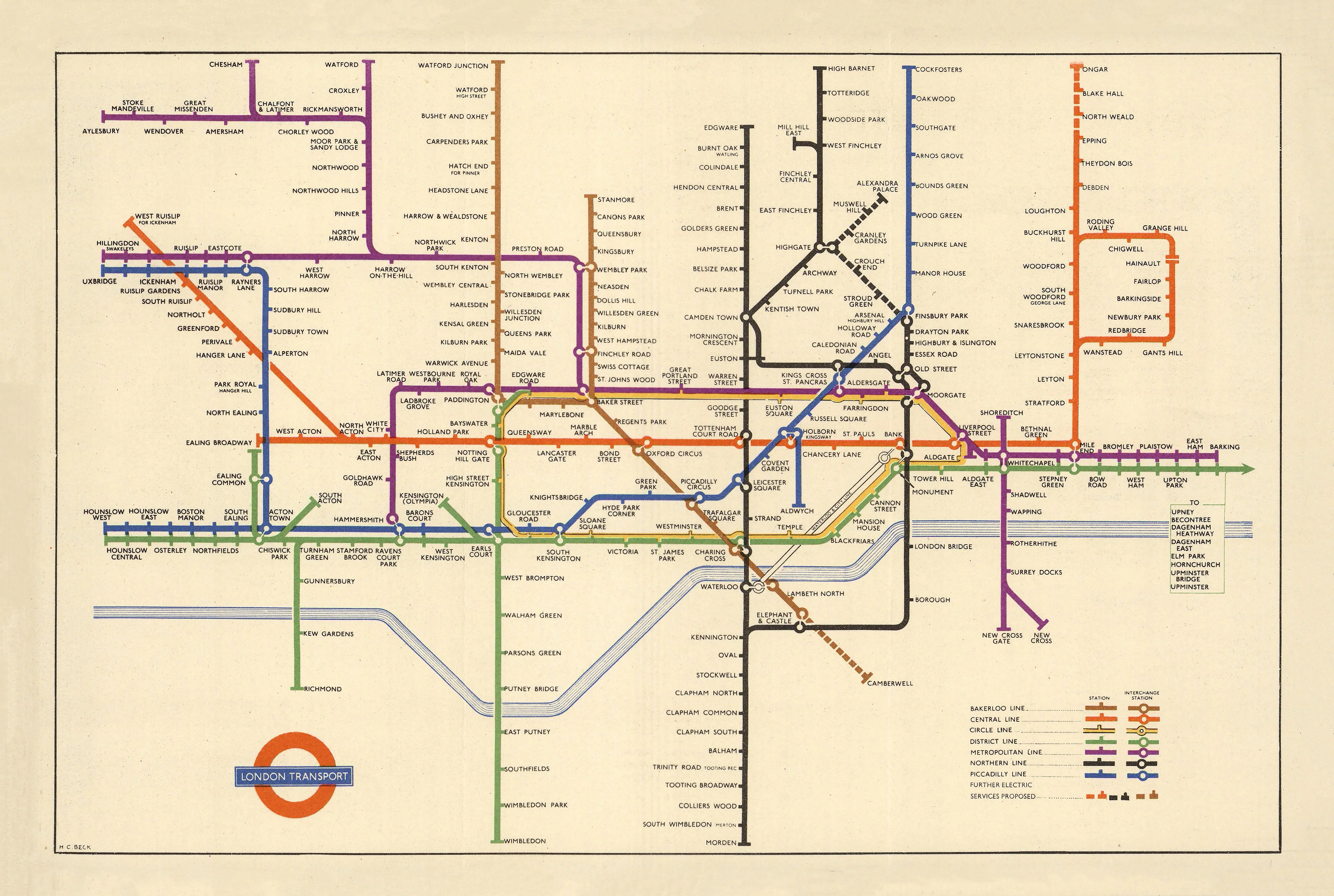
London Underground, designed by Henry Charles Beck (1950)
Refined Schematic Classic | Evolution of an Icon | Premium Wall Format (841 × 565 mm)
By 1950, Henry Charles Beck’s revolutionary vision had matured into one of the most recognisable design systems in the world. This edition of the London Underground map represents a refined evolution of his original 1933 concept—clearer, more structured, and perfectly attuned to a growing post-war city.
Still grounded in the same principles—clarity over geography, logic over scale—the 1950 map shows a network that has expanded and stabilised. It is a moment where innovation meets standardisation: Beck’s once-radical idea is now the accepted visual language of urban transit.
This edition captures that balance beautifully—a working map, a design milestone, and a timeless wall piece.
⚓ Why This Map Stands Out
A mature evolution of a design classic
By 1950, Beck’s schematic system had been refined into a cleaner, more consistent layout—arguably closer to the modern maps we recognise today.
Post-war London in transition
Reflects a city rebuilding and expanding—offering a snapshot of London’s transport network in a new era.
Clarity perfected
Line spacing, typography, and interchange design are more resolved, enhancing readability across the network.
Enduring global influence
This version represents the stage at which Beck’s system became firmly embedded worldwide.
A design icon with presence
Scaled to a large wall format, it becomes both a functional diagram and a striking visual centrepiece.
🗺️ What the Map Shows
- The expanded mid-20th-century network of the London Underground
- Clearly colour-coded lines including Central, Piccadilly, Bakerloo, District, Metropolitan, and Northern lines
- Major interchange stations such as Oxford Circus, Waterloo, King’s Cross, and Liverpool Street
- A refined schematic layout using horizontal, vertical, and 45° angles
- Improved spacing and alignment for clearer navigation and visual balance
This is the Underground as a fully realised system—designed to be understood instantly.
📐 Size & Format
841 mm (W) × 565 mm (H)
Landscape orientation
A slightly more compact height than earlier editions, giving this version a sleek, horizontal emphasis—ideal for:
- Offices and studios
- Hallways and workspaces
- Design-led interiors
- Educational environments
✨ Premium Finishes
| Format | Description |
|---|---|
| 📜 Paper (160 gsm) | Heavyweight matte-coated paper—perfect for framing. Preserves sharp linework and colour clarity. |
| 🧼 Laminated (Encapsulated) | Sealed in 2 × 80-micron gloss laminate. Durable, wipe-clean, and ideal for high-use spaces. |
| 🪵 Laminated + Timber Hang Rails | Laminated map mounted with lacquered natural timber rails and hanging cord—ready to hang. |
| 🖼️ Canvas (395 gsm HP Professional Matte) | Printed with archival pigment inks. Subtle texture enhances the graphic quality while reducing glare. |
| 🪵 Canvas + Timber Hang Rails | Canvas finished with timber rails for a refined, gallery-style presentation. |
🔨 Please allow up to 10 working days for professionally mounted hang-railed finishes.
📊 Specifications
| Feature | Detail |
|---|---|
| Title | Map of London’s Underground Railways |
| Designer | Henry Charles Beck |
| Date | 1950 Edition |
| Publisher | London Transport |
| Dimensions | 841 mm × 565 mm |
| Orientation | Landscape |
| Style | Schematic / Diagrammatic |
| Printing (This Edition) | Pigment-based, fade-resistant inks |
| Origin | Printed and finished in Australia |
🎯 Ideal For
- Designers and creatives drawn to clean systems and visual logic
- Collectors of mid-century and modernist design
- Transport enthusiasts and London aficionados
- Offices seeking a smart, structured visual focal point
- Educators exploring information design and urban infrastructure
🎨 A Design That Defined a Standard
The brilliance of Beck’s work lies not just in invention—but in refinement. By 1950:
- The schematic approach had proven its value
- The layout became more consistent and scalable
- The visual language was fully adopted across the network
This edition shows the moment when Beck’s idea became the standard—not the exception.
It’s a powerful reminder that great design doesn’t just solve problems—it reshapes expectations.
🚇 Cultural Significance
As London rebuilt after World War II, the Underground remained the city’s lifeline. This map reflects:
- A stabilising transport system
- A growing urban population
- A design language that made complexity manageable
It is both a functional tool and a symbol of modern urban life.
🤝 Our Commitment
- Printed in Australia using archival-quality processes
- Faithful reproduction of original colours and linework
- Premium materials selected for durability and clarity
- Each print is hand-checked before dispatch
- Carefully packaged for safe delivery
🚚 Delivery
- Paper, Laminated, Canvas (rolled): Dispatch within 1–2 business days
- Hang-Railed Maps: Made to order—allow up to 10 working days
- Packaging: Securely rolled in protective tubing
Bring the clarity, logic, and enduring beauty of Beck’s design into your space—
a map that shows how great thinking can transform the everyday.
👉 Order now and own a refined classic of modern design.
Product Information
Product Information
Shipping & Returns
Shipping & Returns
Description
Refined Schematic Classic | Evolution of an Icon | Premium Wall Format (841 × 565 mm)
By 1950, Henry Charles Beck’s revolutionary vision had matured into one of the most recognisable design systems in the world. This edition of the London Underground map represents a refined evolution of his original 1933 concept—clearer, more structured, and perfectly attuned to a growing post-war city.
Still grounded in the same principles—clarity over geography, logic over scale—the 1950 map shows a network that has expanded and stabilised. It is a moment where innovation meets standardisation: Beck’s once-radical idea is now the accepted visual language of urban transit.
This edition captures that balance beautifully—a working map, a design milestone, and a timeless wall piece.
⚓ Why This Map Stands Out
A mature evolution of a design classic
By 1950, Beck’s schematic system had been refined into a cleaner, more consistent layout—arguably closer to the modern maps we recognise today.
Post-war London in transition
Reflects a city rebuilding and expanding—offering a snapshot of London’s transport network in a new era.
Clarity perfected
Line spacing, typography, and interchange design are more resolved, enhancing readability across the network.
Enduring global influence
This version represents the stage at which Beck’s system became firmly embedded worldwide.
A design icon with presence
Scaled to a large wall format, it becomes both a functional diagram and a striking visual centrepiece.
🗺️ What the Map Shows
- The expanded mid-20th-century network of the London Underground
- Clearly colour-coded lines including Central, Piccadilly, Bakerloo, District, Metropolitan, and Northern lines
- Major interchange stations such as Oxford Circus, Waterloo, King’s Cross, and Liverpool Street
- A refined schematic layout using horizontal, vertical, and 45° angles
- Improved spacing and alignment for clearer navigation and visual balance
This is the Underground as a fully realised system—designed to be understood instantly.
📐 Size & Format
841 mm (W) × 565 mm (H)
Landscape orientation
A slightly more compact height than earlier editions, giving this version a sleek, horizontal emphasis—ideal for:
- Offices and studios
- Hallways and workspaces
- Design-led interiors
- Educational environments
✨ Premium Finishes
| Format | Description |
|---|---|
| 📜 Paper (160 gsm) | Heavyweight matte-coated paper—perfect for framing. Preserves sharp linework and colour clarity. |
| 🧼 Laminated (Encapsulated) | Sealed in 2 × 80-micron gloss laminate. Durable, wipe-clean, and ideal for high-use spaces. |
| 🪵 Laminated + Timber Hang Rails | Laminated map mounted with lacquered natural timber rails and hanging cord—ready to hang. |
| 🖼️ Canvas (395 gsm HP Professional Matte) | Printed with archival pigment inks. Subtle texture enhances the graphic quality while reducing glare. |
| 🪵 Canvas + Timber Hang Rails | Canvas finished with timber rails for a refined, gallery-style presentation. |
🔨 Please allow up to 10 working days for professionally mounted hang-railed finishes.
📊 Specifications
| Feature | Detail |
|---|---|
| Title | Map of London’s Underground Railways |
| Designer | Henry Charles Beck |
| Date | 1950 Edition |
| Publisher | London Transport |
| Dimensions | 841 mm × 565 mm |
| Orientation | Landscape |
| Style | Schematic / Diagrammatic |
| Printing (This Edition) | Pigment-based, fade-resistant inks |
| Origin | Printed and finished in Australia |
🎯 Ideal For
- Designers and creatives drawn to clean systems and visual logic
- Collectors of mid-century and modernist design
- Transport enthusiasts and London aficionados
- Offices seeking a smart, structured visual focal point
- Educators exploring information design and urban infrastructure
🎨 A Design That Defined a Standard
The brilliance of Beck’s work lies not just in invention—but in refinement. By 1950:
- The schematic approach had proven its value
- The layout became more consistent and scalable
- The visual language was fully adopted across the network
This edition shows the moment when Beck’s idea became the standard—not the exception.
It’s a powerful reminder that great design doesn’t just solve problems—it reshapes expectations.
🚇 Cultural Significance
As London rebuilt after World War II, the Underground remained the city’s lifeline. This map reflects:
- A stabilising transport system
- A growing urban population
- A design language that made complexity manageable
It is both a functional tool and a symbol of modern urban life.
🤝 Our Commitment
- Printed in Australia using archival-quality processes
- Faithful reproduction of original colours and linework
- Premium materials selected for durability and clarity
- Each print is hand-checked before dispatch
- Carefully packaged for safe delivery
🚚 Delivery
- Paper, Laminated, Canvas (rolled): Dispatch within 1–2 business days
- Hang-Railed Maps: Made to order—allow up to 10 working days
- Packaging: Securely rolled in protective tubing
Bring the clarity, logic, and enduring beauty of Beck’s design into your space—
a map that shows how great thinking can transform the everyday.
👉 Order now and own a refined classic of modern design.