Maine by National Geographic
Physical Wall Map | Forests, Coastlines & Mountain Landscapes | Large Format (1029 × 768 mm) | Premium Finishes
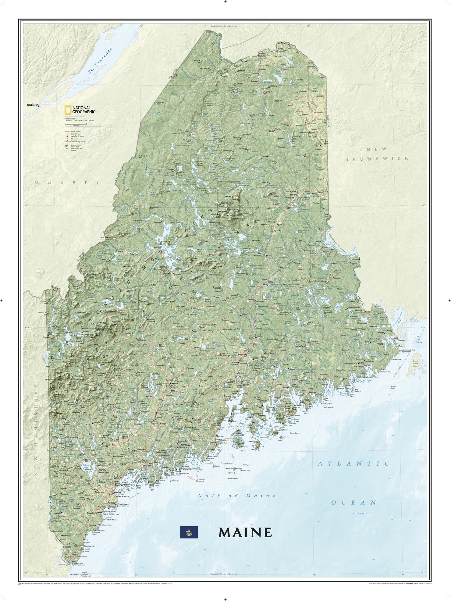
A beautifully rendered portrait of New England’s northernmost state, Maine captures the rugged beauty and natural character of the Pine Tree State in exceptional detail. Published by National Geographic, this map combines vivid colour, shaded relief, and precise cartography to bring the landscape to life.
From forested interiors to the dramatic Atlantic coastline, it offers a complete and immersive view of Maine—a region defined by wilderness, water, and elevation.
Why This Map Stands Out
Striking physical detail
Shaded relief highlights Maine’s mountains, forests, and waterways.
Comprehensive coverage
Shows the entire state from the New Hampshire border to the Canadian frontier and Atlantic coast.
Highly readable cartography
Carefully placed labels ensure clarity across a large, information-rich map.
Balanced design and colour
National Geographic’s signature palette enhances terrain and depth.
A versatile wall map
Ideal for both reference and display.
🗺️ What the Map Shows
- The full extent of Maine, including:
- Mountain ranges and elevated terrain
- Extensive forests and wilderness areas
- Lakes, rivers, and coastal bays
- The rugged Atlantic coastline, with inlets and peninsulas
- Cities, towns, and key settlements across the state
- National and state parks, protected areas, and historic sites
- Recreation features including ski areas and notable peaks
- Infrastructure networks:
- Major roads and highways
- Airports and ferry routes
📐 Size & Format
1029 mm (H) × 768 mm (W)
Portrait orientation
A large, high-impact format ideal for:
- Classrooms and geography education
- Offices and planning environments
- Home studies and workspaces
- Feature walls showcasing natural landscapes
✨ Premium Finishes
| Format | Description |
|---|---|
| 📜 Paper (160 gsm) | Heavyweight matte-coated paper—ideal for framing. Preserves fine terrain detail. |
| 🧼 Laminated (Encapsulated) | Sealed in 2 × 80-micron gloss laminate. Durable, wipe-clean, and suitable for frequent reference. |
| 🪵 Laminated + Timber Hang Rails | Laminated map mounted with lacquered natural timber rails and hanging cord—ready to display. |
| 🖼️ Canvas (395 gsm HP Professional Matte) | Printed with archival pigment inks. Enhances depth and shaded relief. |
| 🪵 Canvas + Timber Hang Rails | Canvas paired with timber rails for a refined, gallery-style presentation. |
🔨 Please allow up to 10 working days for professionally mounted hang-railed finishes.
📊 Specifications
| Feature | Detail |
|---|---|
| Title | Maine |
| Publisher | National Geographic |
| Published | 2016 |
| Scale | 1:524,329 |
| Dimensions | 1029 mm × 768 mm |
| Orientation | Portrait |
| Map Type | Physical |
| Coverage | Maine, USA |
| Collections | USA, Physical |
| Materials | 160 gsm matte paper / 2 × 80-micron laminate / 395 gsm HP Professional Matte Canvas |
| Printing | Pigment-based, fade-resistant inks |
| Origin | Printed in Australia |
🎯 Ideal For
- Students and educators of geography and environmental science
- Outdoor enthusiasts exploring Maine’s wilderness
- Collectors of National Geographic physical maps
- Interiors seeking a nature-inspired display piece
- Gift buyers looking for a detailed and visually striking map
🌲 The Pine Tree State in Full Detail
Maine is a landscape of contrasts:
- Dense forests stretching across vast interior regions
- Mountain ranges rising through rugged terrain
- A deeply indented coastline shaped by the Atlantic
- A place where wilderness and settlement meet
This map captures that diversity—offering a clear and compelling view of a state defined by nature, scale, and beauty.
🤝 Our Commitment
- Printed in Australia using archival-quality production
- Faithfully reproduced to preserve colour, clarity, and detail
- Premium materials selected for durability and long-term display
- Each map is hand-checked before dispatch
- Carefully packaged for safe delivery
🚚 Delivery
- Paper, Laminated, Canvas (rolled): Dispatch within 1–2 business days
- Hang-Railed Maps: Made to order—allow up to 10 working days
- Packaging: Securely rolled in protective tubing
Explore Maine in rich geographic detail—
a map that brings the Pine Tree State into vivid focus.
👉 Order now and add a striking natural landscape to your wall.
Original: $57.20
-65%$57.20
$20.02Product Information
Product Information
Shipping & Returns
Shipping & Returns
Description
Physical Wall Map | Forests, Coastlines & Mountain Landscapes | Large Format (1029 × 768 mm) | Premium Finishes
A beautifully rendered portrait of New England’s northernmost state, Maine captures the rugged beauty and natural character of the Pine Tree State in exceptional detail. Published by National Geographic, this map combines vivid colour, shaded relief, and precise cartography to bring the landscape to life.
From forested interiors to the dramatic Atlantic coastline, it offers a complete and immersive view of Maine—a region defined by wilderness, water, and elevation.
Why This Map Stands Out
Striking physical detail
Shaded relief highlights Maine’s mountains, forests, and waterways.
Comprehensive coverage
Shows the entire state from the New Hampshire border to the Canadian frontier and Atlantic coast.
Highly readable cartography
Carefully placed labels ensure clarity across a large, information-rich map.
Balanced design and colour
National Geographic’s signature palette enhances terrain and depth.
A versatile wall map
Ideal for both reference and display.
🗺️ What the Map Shows
- The full extent of Maine, including:
- Mountain ranges and elevated terrain
- Extensive forests and wilderness areas
- Lakes, rivers, and coastal bays
- The rugged Atlantic coastline, with inlets and peninsulas
- Cities, towns, and key settlements across the state
- National and state parks, protected areas, and historic sites
- Recreation features including ski areas and notable peaks
- Infrastructure networks:
- Major roads and highways
- Airports and ferry routes
📐 Size & Format
1029 mm (H) × 768 mm (W)
Portrait orientation
A large, high-impact format ideal for:
- Classrooms and geography education
- Offices and planning environments
- Home studies and workspaces
- Feature walls showcasing natural landscapes
✨ Premium Finishes
| Format | Description |
|---|---|
| 📜 Paper (160 gsm) | Heavyweight matte-coated paper—ideal for framing. Preserves fine terrain detail. |
| 🧼 Laminated (Encapsulated) | Sealed in 2 × 80-micron gloss laminate. Durable, wipe-clean, and suitable for frequent reference. |
| 🪵 Laminated + Timber Hang Rails | Laminated map mounted with lacquered natural timber rails and hanging cord—ready to display. |
| 🖼️ Canvas (395 gsm HP Professional Matte) | Printed with archival pigment inks. Enhances depth and shaded relief. |
| 🪵 Canvas + Timber Hang Rails | Canvas paired with timber rails for a refined, gallery-style presentation. |
🔨 Please allow up to 10 working days for professionally mounted hang-railed finishes.
📊 Specifications
| Feature | Detail |
|---|---|
| Title | Maine |
| Publisher | National Geographic |
| Published | 2016 |
| Scale | 1:524,329 |
| Dimensions | 1029 mm × 768 mm |
| Orientation | Portrait |
| Map Type | Physical |
| Coverage | Maine, USA |
| Collections | USA, Physical |
| Materials | 160 gsm matte paper / 2 × 80-micron laminate / 395 gsm HP Professional Matte Canvas |
| Printing | Pigment-based, fade-resistant inks |
| Origin | Printed in Australia |
🎯 Ideal For
- Students and educators of geography and environmental science
- Outdoor enthusiasts exploring Maine’s wilderness
- Collectors of National Geographic physical maps
- Interiors seeking a nature-inspired display piece
- Gift buyers looking for a detailed and visually striking map
🌲 The Pine Tree State in Full Detail
Maine is a landscape of contrasts:
- Dense forests stretching across vast interior regions
- Mountain ranges rising through rugged terrain
- A deeply indented coastline shaped by the Atlantic
- A place where wilderness and settlement meet
This map captures that diversity—offering a clear and compelling view of a state defined by nature, scale, and beauty.
🤝 Our Commitment
- Printed in Australia using archival-quality production
- Faithfully reproduced to preserve colour, clarity, and detail
- Premium materials selected for durability and long-term display
- Each map is hand-checked before dispatch
- Carefully packaged for safe delivery
🚚 Delivery
- Paper, Laminated, Canvas (rolled): Dispatch within 1–2 business days
- Hang-Railed Maps: Made to order—allow up to 10 working days
- Packaging: Securely rolled in protective tubing
Explore Maine in rich geographic detail—
a map that brings the Pine Tree State into vivid focus.
👉 Order now and add a striking natural landscape to your wall.


