Making of America, Atlantic Gateways - Published 1983
Historical Regional Map | Eastern Seaboard & Founding Cities | Wall Format (683 × 519 mm) | Premium Finishes
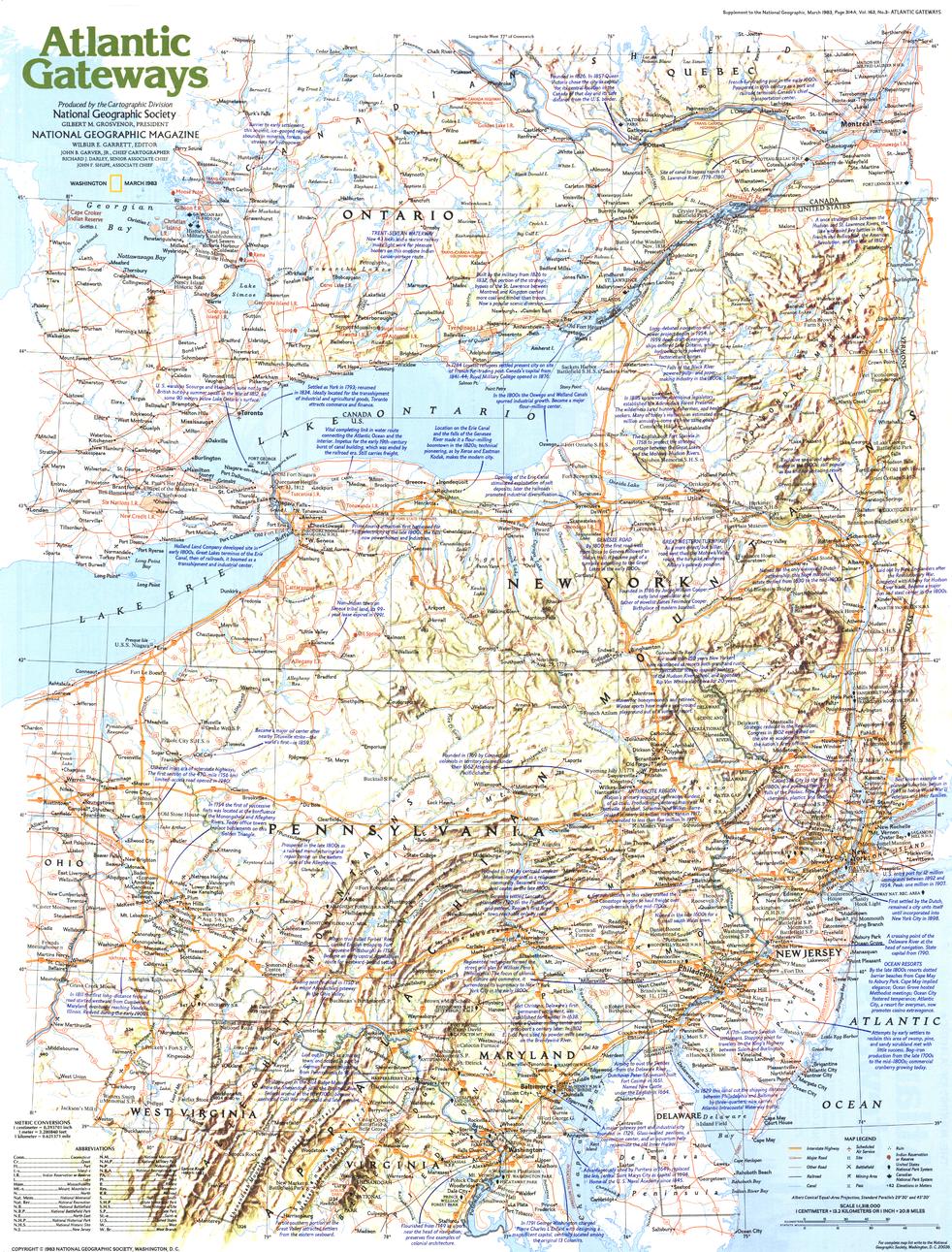
A compelling exploration of the eastern seaboard’s enduring influence, Atlantic Gateways traces the development of one of the most historically significant regions in the United States. Published by National Geographic in March 1983 as part of the Making of America series, this map brings together early colonial history, urban growth, and modern geography in one cohesive view.
From the first European settlements to the rise of major cities like New York City, Philadelphia, and Washington, D.C., it captures the region where America’s story first took shape.
Why This Map Stands Out
A cradle of American history
Explores the region where early settlements evolved into major national centres.
Part of the Making of America series
Combines historical narrative with geographic clarity.
Rich educational value
Links past and present through layered mapping and context.
Balanced regional perspective
Focuses on the central Atlantic states and their interconnected development.
A thoughtful wall map
Ideal for both study and display.
🗺️ What the Map Shows
- The Atlantic seaboard region of the United States
- Key early colonial settlements and expansion corridors
- Major cities including New York, Philadelphia, and Washington, D.C.
- Transportation routes and geographic connections shaping growth
- Coastal features and inland waterways
- A regional framework linking history, trade, and urban development
📐 Size & Format
683 mm (W) × 519 mm (H)
Landscape orientation
A practical, display-friendly format ideal for:
- Classrooms and history education
- Home offices and studies
- Libraries and heritage displays
- Interiors focused on American history
✨ Premium Finishes
| Format | Description |
|---|---|
| 📜 Paper (160 gsm) | Heavyweight matte-coated paper—ideal for framing. Preserves clarity and historical detail. |
| 🧼 Laminated (Encapsulated) | Sealed in 2 × 80-micron gloss laminate. Durable, wipe-clean, and suitable for reference use. |
| 🪵 Laminated + Timber Hang Rails | Laminated map mounted with lacquered natural timber rails and hanging cord—ready to display. |
| 🖼️ Canvas (395 gsm HP Professional Matte) | Printed with archival pigment inks. Adds depth and a refined finish. |
| 🪵 Canvas + Timber Hang Rails | Canvas paired with timber rails for a gallery-style presentation. |
🔨 Please allow up to 10 working days for professionally mounted hang-railed finishes.
📊 Specifications
| Feature | Detail |
|---|---|
| Title | Making of America: Atlantic Gateways |
| Publisher | National Geographic |
| Published | 1983 |
| Scale | 1:1,318,000 |
| Dimensions | 683 mm × 519 mm |
| Orientation | Landscape |
| Map Type | Historical / Regional |
| Coverage | Eastern United States (Atlantic Seaboard) |
| Collections | USA, Historical, Regional |
| Materials | 160 gsm matte paper / 2 × 80-micron laminate / 395 gsm HP Professional Matte Canvas |
| Printing | Pigment-based, fade-resistant inks |
| Origin | Printed in Australia |
🎯 Ideal For
- Students and educators of American history
- Enthusiasts of colonial and early U.S. development
- Collectors of National Geographic historical maps
- Interiors seeking a heritage-inspired display piece
- Gift buyers looking for a meaningful and educational map
⚓ Gateway to a Nation
The Atlantic seaboard is where America began:
- Early ports linking the New World to Europe
- Cities that became centres of politics, trade, and culture
- Landscapes shaped by migration, commerce, and conflict
- A region that continues to influence the nation today
This map captures that legacy—offering a window into the places where America’s story first unfolded.
🤝 Our Commitment
- Printed in Australia using archival-quality production
- Faithfully reproduced to preserve clarity and historical detail
- Premium materials selected for durability and longevity
- Each map is hand-checked before dispatch
- Carefully packaged for safe delivery
🚚 Delivery
- Paper, Laminated, Canvas (rolled): Dispatch within 1–2 business days
- Hang-Railed Maps: Made to order—allow up to 10 working days
- Packaging: Securely rolled in protective tubing
Explore the gateway to America’s past—
a map that brings history, geography, and nation-building into focus.
👉 Order now and add a foundational piece of American history to your wall.
Original: $57.20
-65%$57.20
$20.02Product Information
Product Information
Shipping & Returns
Shipping & Returns
Description
Historical Regional Map | Eastern Seaboard & Founding Cities | Wall Format (683 × 519 mm) | Premium Finishes
A compelling exploration of the eastern seaboard’s enduring influence, Atlantic Gateways traces the development of one of the most historically significant regions in the United States. Published by National Geographic in March 1983 as part of the Making of America series, this map brings together early colonial history, urban growth, and modern geography in one cohesive view.
From the first European settlements to the rise of major cities like New York City, Philadelphia, and Washington, D.C., it captures the region where America’s story first took shape.
Why This Map Stands Out
A cradle of American history
Explores the region where early settlements evolved into major national centres.
Part of the Making of America series
Combines historical narrative with geographic clarity.
Rich educational value
Links past and present through layered mapping and context.
Balanced regional perspective
Focuses on the central Atlantic states and their interconnected development.
A thoughtful wall map
Ideal for both study and display.
🗺️ What the Map Shows
- The Atlantic seaboard region of the United States
- Key early colonial settlements and expansion corridors
- Major cities including New York, Philadelphia, and Washington, D.C.
- Transportation routes and geographic connections shaping growth
- Coastal features and inland waterways
- A regional framework linking history, trade, and urban development
📐 Size & Format
683 mm (W) × 519 mm (H)
Landscape orientation
A practical, display-friendly format ideal for:
- Classrooms and history education
- Home offices and studies
- Libraries and heritage displays
- Interiors focused on American history
✨ Premium Finishes
| Format | Description |
|---|---|
| 📜 Paper (160 gsm) | Heavyweight matte-coated paper—ideal for framing. Preserves clarity and historical detail. |
| 🧼 Laminated (Encapsulated) | Sealed in 2 × 80-micron gloss laminate. Durable, wipe-clean, and suitable for reference use. |
| 🪵 Laminated + Timber Hang Rails | Laminated map mounted with lacquered natural timber rails and hanging cord—ready to display. |
| 🖼️ Canvas (395 gsm HP Professional Matte) | Printed with archival pigment inks. Adds depth and a refined finish. |
| 🪵 Canvas + Timber Hang Rails | Canvas paired with timber rails for a gallery-style presentation. |
🔨 Please allow up to 10 working days for professionally mounted hang-railed finishes.
📊 Specifications
| Feature | Detail |
|---|---|
| Title | Making of America: Atlantic Gateways |
| Publisher | National Geographic |
| Published | 1983 |
| Scale | 1:1,318,000 |
| Dimensions | 683 mm × 519 mm |
| Orientation | Landscape |
| Map Type | Historical / Regional |
| Coverage | Eastern United States (Atlantic Seaboard) |
| Collections | USA, Historical, Regional |
| Materials | 160 gsm matte paper / 2 × 80-micron laminate / 395 gsm HP Professional Matte Canvas |
| Printing | Pigment-based, fade-resistant inks |
| Origin | Printed in Australia |
🎯 Ideal For
- Students and educators of American history
- Enthusiasts of colonial and early U.S. development
- Collectors of National Geographic historical maps
- Interiors seeking a heritage-inspired display piece
- Gift buyers looking for a meaningful and educational map
⚓ Gateway to a Nation
The Atlantic seaboard is where America began:
- Early ports linking the New World to Europe
- Cities that became centres of politics, trade, and culture
- Landscapes shaped by migration, commerce, and conflict
- A region that continues to influence the nation today
This map captures that legacy—offering a window into the places where America’s story first unfolded.
🤝 Our Commitment
- Printed in Australia using archival-quality production
- Faithfully reproduced to preserve clarity and historical detail
- Premium materials selected for durability and longevity
- Each map is hand-checked before dispatch
- Carefully packaged for safe delivery
🚚 Delivery
- Paper, Laminated, Canvas (rolled): Dispatch within 1–2 business days
- Hang-Railed Maps: Made to order—allow up to 10 working days
- Packaging: Securely rolled in protective tubing
Explore the gateway to America’s past—
a map that brings history, geography, and nation-building into focus.
👉 Order now and add a foundational piece of American history to your wall.


