Making of America, Atlantic Gateways Theme - Published 1983 by National Geographic
Historical Companion Map | Eastern Seaboard States in Focus | Wall Format (685 × 518 mm) | Premium Finishes
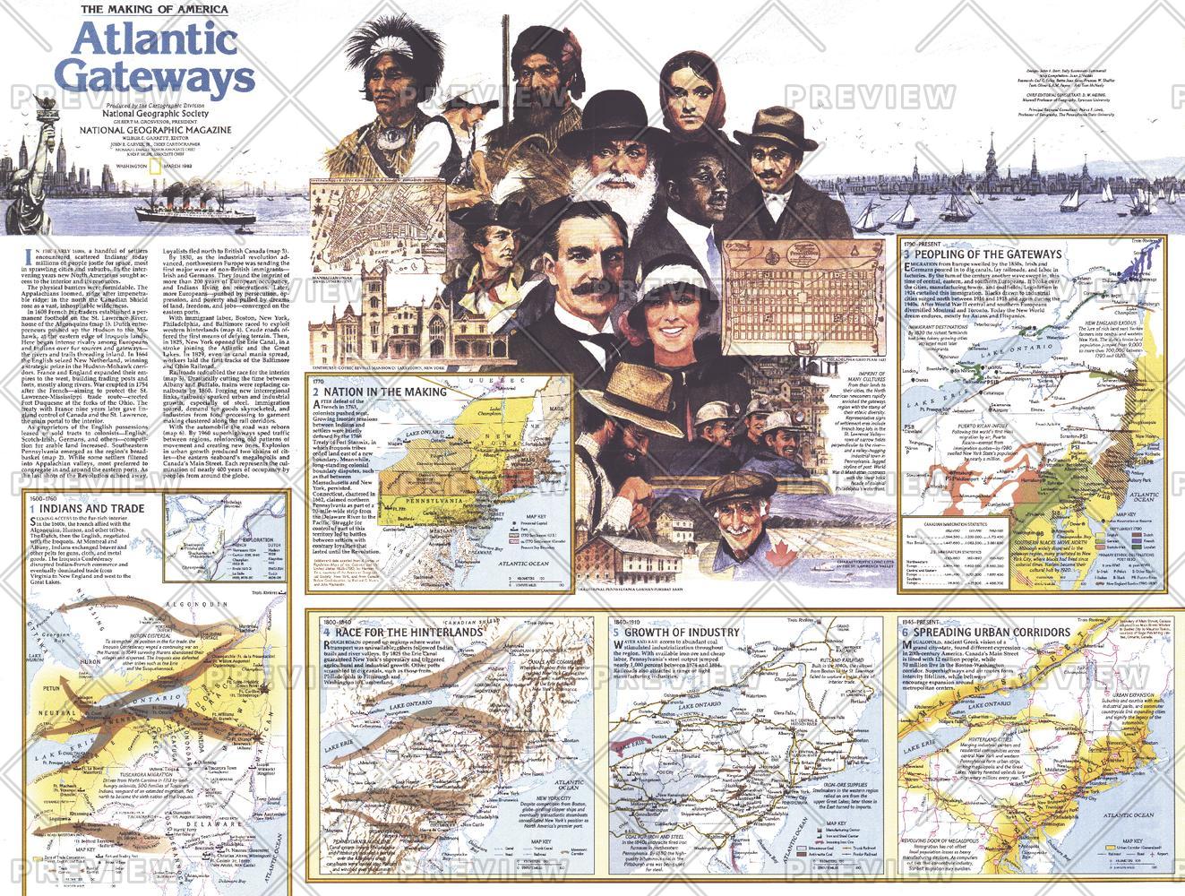
A rich companion to the primary Atlantic Gateways map, this Theme Map (Side Two) expands the story of America’s eastern seaboard with deeper historical insight and regional detail. Published by National Geographic in March 1983 as part of the Making of America series, it offers a layered look at the states where early settlement, commerce, and nation-building converged.
Focusing on the central Atlantic corridor—including New York, Pennsylvania, New Jersey, Maryland, Rhode Island, northern Virginia, and southern Massachusetts—this map connects geography with the forces that shaped the early United States.
Why This Map Stands Out
A deeper historical layer
Expands on the Atlantic Gateways story with added context and detail.
Part of a two-map set
Designed as Side Two, complementing the primary regional map.
Focused regional insight
Highlights key states central to early American development.
Educational and narrative-rich
Blends geography with historical interpretation.
A refined display piece
Ideal for pairing with the companion map or standing alone.
🗺️ What the Map Shows
- The central Atlantic seaboard region of the United States
- Key states including New York, Pennsylvania, New Jersey, Maryland, and Rhode Island
- Northern Virginia and southern Massachusetts as part of the broader region
- Historical context tied to colonial expansion, trade, and urban growth
- Geographic connections between coastal ports and inland areas
- A thematic overview of how this region shaped early American identity
📐 Size & Format
685 mm (W) × 518 mm (H)
Landscape orientation
A balanced format ideal for:
- Classrooms and history education
- Home offices and studies
- Libraries and heritage displays
- Paired display with the main Atlantic Gateways map
✨ Premium Finishes
| Format | Description |
|---|---|
| 📜 Paper (160 gsm) | Heavyweight matte-coated paper—ideal for framing. Preserves clarity and fine historical detail. |
| 🧼 Laminated (Encapsulated) | Sealed in 2 × 80-micron gloss laminate. Durable, wipe-clean, and suitable for reference use. |
| 🪵 Laminated + Timber Hang Rails | Laminated map mounted with lacquered natural timber rails and hanging cord—ready to display. |
| 🖼️ Canvas (395 gsm HP Professional Matte) | Printed with archival pigment inks. Adds depth and a refined finish. |
| 🪵 Canvas + Timber Hang Rails | Canvas paired with timber rails for a gallery-style presentation. |
🔨 Please allow up to 10 working days for professionally mounted hang-railed finishes.
📊 Specifications
| Feature | Detail |
|---|---|
| Title | Making of America: Atlantic Gateways — Theme Map |
| Publisher | National Geographic |
| Published | 1983 |
| Dimensions | 685 mm × 518 mm |
| Orientation | Landscape |
| Map Type | Historical / Thematic |
| Coverage | Central Eastern United States |
| Collections | North America, Historical |
| Materials | 160 gsm matte paper / 2 × 80-micron laminate / 395 gsm HP Professional Matte Canvas |
| Printing | Pigment-based, fade-resistant inks |
| Origin | Printed in Australia |
🎯 Ideal For
- Students and educators of American colonial and early national history
- Collectors of National Geographic historical series maps
- Enthusiasts of the eastern seaboard’s development
- Interiors seeking a heritage-focused display piece
- Gift buyers looking for a thoughtful companion map
⚓ Where a Nation Took Shape
This region was central to America’s beginnings:
- Ports linking the colonies to global trade
- Cities emerging as centres of politics and culture
- Landscapes shaped by migration and industry
- A corridor where history and geography are deeply intertwined
This map brings that story into sharper focus—offering a deeper understanding of the places where America’s foundations were laid.
🤝 Our Commitment
- Printed in Australia using archival-quality production
- Faithfully reproduced to preserve clarity and historical detail
- Premium materials selected for durability and longevity
- Each map is hand-checked before dispatch
- Carefully packaged for safe delivery
🚚 Delivery
- Paper, Laminated, Canvas (rolled): Dispatch within 1–2 business days
- Hang-Railed Maps: Made to order—allow up to 10 working days
- Packaging: Securely rolled in protective tubing
Complete the Atlantic Gateways story—
a map that adds depth to the geography and history of America’s eastern seaboard.
👉 Order now and pair it with the companion map for a complete historical view.
Original: $57.20
-65%$57.20
$20.02Product Information
Product Information
Shipping & Returns
Shipping & Returns
Description
Historical Companion Map | Eastern Seaboard States in Focus | Wall Format (685 × 518 mm) | Premium Finishes
A rich companion to the primary Atlantic Gateways map, this Theme Map (Side Two) expands the story of America’s eastern seaboard with deeper historical insight and regional detail. Published by National Geographic in March 1983 as part of the Making of America series, it offers a layered look at the states where early settlement, commerce, and nation-building converged.
Focusing on the central Atlantic corridor—including New York, Pennsylvania, New Jersey, Maryland, Rhode Island, northern Virginia, and southern Massachusetts—this map connects geography with the forces that shaped the early United States.
Why This Map Stands Out
A deeper historical layer
Expands on the Atlantic Gateways story with added context and detail.
Part of a two-map set
Designed as Side Two, complementing the primary regional map.
Focused regional insight
Highlights key states central to early American development.
Educational and narrative-rich
Blends geography with historical interpretation.
A refined display piece
Ideal for pairing with the companion map or standing alone.
🗺️ What the Map Shows
- The central Atlantic seaboard region of the United States
- Key states including New York, Pennsylvania, New Jersey, Maryland, and Rhode Island
- Northern Virginia and southern Massachusetts as part of the broader region
- Historical context tied to colonial expansion, trade, and urban growth
- Geographic connections between coastal ports and inland areas
- A thematic overview of how this region shaped early American identity
📐 Size & Format
685 mm (W) × 518 mm (H)
Landscape orientation
A balanced format ideal for:
- Classrooms and history education
- Home offices and studies
- Libraries and heritage displays
- Paired display with the main Atlantic Gateways map
✨ Premium Finishes
| Format | Description |
|---|---|
| 📜 Paper (160 gsm) | Heavyweight matte-coated paper—ideal for framing. Preserves clarity and fine historical detail. |
| 🧼 Laminated (Encapsulated) | Sealed in 2 × 80-micron gloss laminate. Durable, wipe-clean, and suitable for reference use. |
| 🪵 Laminated + Timber Hang Rails | Laminated map mounted with lacquered natural timber rails and hanging cord—ready to display. |
| 🖼️ Canvas (395 gsm HP Professional Matte) | Printed with archival pigment inks. Adds depth and a refined finish. |
| 🪵 Canvas + Timber Hang Rails | Canvas paired with timber rails for a gallery-style presentation. |
🔨 Please allow up to 10 working days for professionally mounted hang-railed finishes.
📊 Specifications
| Feature | Detail |
|---|---|
| Title | Making of America: Atlantic Gateways — Theme Map |
| Publisher | National Geographic |
| Published | 1983 |
| Dimensions | 685 mm × 518 mm |
| Orientation | Landscape |
| Map Type | Historical / Thematic |
| Coverage | Central Eastern United States |
| Collections | North America, Historical |
| Materials | 160 gsm matte paper / 2 × 80-micron laminate / 395 gsm HP Professional Matte Canvas |
| Printing | Pigment-based, fade-resistant inks |
| Origin | Printed in Australia |
🎯 Ideal For
- Students and educators of American colonial and early national history
- Collectors of National Geographic historical series maps
- Enthusiasts of the eastern seaboard’s development
- Interiors seeking a heritage-focused display piece
- Gift buyers looking for a thoughtful companion map
⚓ Where a Nation Took Shape
This region was central to America’s beginnings:
- Ports linking the colonies to global trade
- Cities emerging as centres of politics and culture
- Landscapes shaped by migration and industry
- A corridor where history and geography are deeply intertwined
This map brings that story into sharper focus—offering a deeper understanding of the places where America’s foundations were laid.
🤝 Our Commitment
- Printed in Australia using archival-quality production
- Faithfully reproduced to preserve clarity and historical detail
- Premium materials selected for durability and longevity
- Each map is hand-checked before dispatch
- Carefully packaged for safe delivery
🚚 Delivery
- Paper, Laminated, Canvas (rolled): Dispatch within 1–2 business days
- Hang-Railed Maps: Made to order—allow up to 10 working days
- Packaging: Securely rolled in protective tubing
Complete the Atlantic Gateways story—
a map that adds depth to the geography and history of America’s eastern seaboard.
👉 Order now and pair it with the companion map for a complete historical view.


