Making of America, Far West - Published 1984 by National Geographic
Historical Regional Map | California & Nevada in Focus | Wall Format (687 × 520 mm) | Premium Finishes
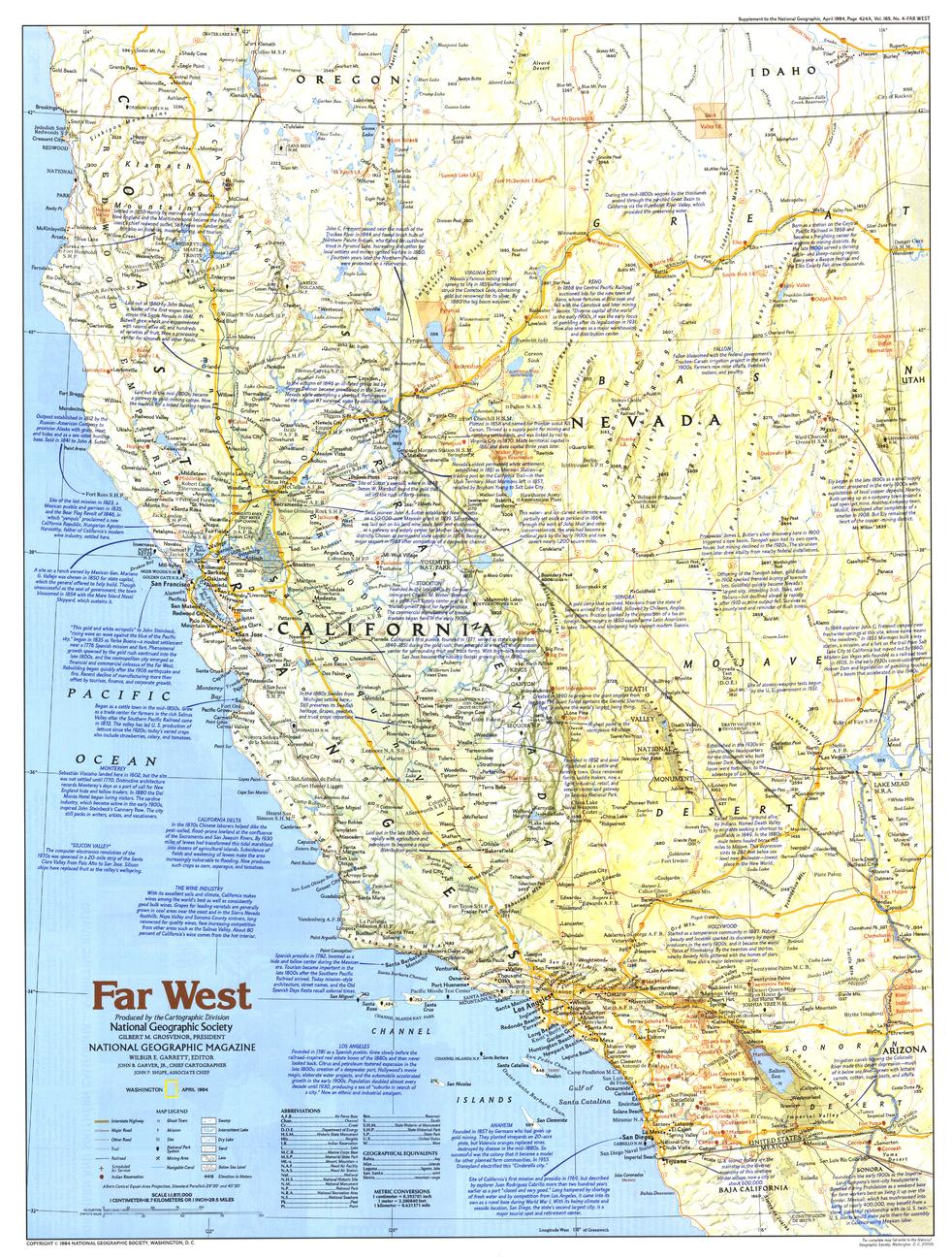
A vivid exploration of the American West, Far West captures the landscapes, history, and enduring appeal of California and Nevada. Published by National Geographic in April 1984 as part of the Making of America series, this map blends historical narrative with geographic clarity—revealing how the “Golden State” and “Silver State” were shaped.
From gold rush frontiers to modern destinations, it presents a region where history, landscape, and opportunity intersect.
Why This Map Stands Out
A classic Western perspective
Explores two of America’s most iconic states in one cohesive view.
Part of the Making of America series
Combines storytelling with precise cartography.
Rich historical context
Highlights the forces that shaped California and Nevada.
Tourism and geography combined
Shows key destinations alongside natural features.
A balanced wall map
Ideal for both learning and display.
🗺️ What the Map Shows
- The Far West region centred on California and Nevada
- Major cities, towns, and transport routes
- Historical context including settlement, expansion, and development
- Natural features such as mountain ranges, deserts, and coastlines
- Key tourist destinations and points of interest
- A regional framework linking geography with the story of the American West
📐 Size & Format
687 mm (H) × 520 mm (W)
Portrait orientation
A practical, display-friendly format ideal for:
- Classrooms and history education
- Home offices and studies
- Libraries and heritage displays
- Interiors inspired by the American West
✨ Premium Finishes
| Format | Description |
|---|---|
| 📜 Paper (160 gsm) | Heavyweight matte-coated paper—ideal for framing. Preserves clarity and fine detail. |
| 🧼 Laminated (Encapsulated) | Sealed in 2 × 80-micron gloss laminate. Durable, wipe-clean, and suitable for reference use. |
| 🪵 Laminated + Timber Hang Rails | Laminated map mounted with lacquered natural timber rails and hanging cord—ready to display. |
| 🖼️ Canvas (395 gsm HP Professional Matte) | Printed with archival pigment inks. Adds depth and a refined finish. |
| 🪵 Canvas + Timber Hang Rails | Canvas paired with timber rails for a gallery-style presentation. |
🔨 Please allow up to 10 working days for professionally mounted hang-railed finishes.
📊 Specifications
| Feature | Detail |
|---|---|
| Title | Making of America: Far West |
| Publisher | National Geographic |
| Published | 1984 |
| Scale | 1:1,871,000 |
| Dimensions | 687 mm × 520 mm |
| Orientation | Landscape |
| Map Type | Historical / Regional |
| Coverage | California & Nevada, USA |
| Collections | USA, Historical, Regional |
| Materials | 160 gsm matte paper / 2 × 80-micron laminate / 395 gsm HP Professional Matte Canvas |
| Printing | Pigment-based, fade-resistant inks |
| Origin | Printed in Australia |
🎯 Ideal For
- Students and educators of American history and geography
- Enthusiasts of the American West and frontier history
- Collectors of National Geographic historical maps
- Interiors seeking a heritage-inspired display piece
- Gift buyers looking for a distinctive regional map
🌄 The Spirit of the West
California and Nevada tell a story of:
- Opportunity and expansion across vast landscapes
- Gold rushes, migration, and rapid growth
- Contrasting environments—from coastlines to deserts
- A region that continues to shape America’s identity
This map captures that spirit—offering a clear and compelling view of the Far West’s enduring legacy.
🤝 Our Commitment
- Printed in Australia using archival-quality production
- Faithfully reproduced to preserve clarity and historical detail
- Premium materials selected for durability and longevity
- Each map is hand-checked before dispatch
- Carefully packaged for safe delivery
🚚 Delivery
- Paper, Laminated, Canvas (rolled): Dispatch within 1–2 business days
- Hang-Railed Maps: Made to order—allow up to 10 working days
- Packaging: Securely rolled in protective tubing
Explore the landscapes that defined the American frontier—
a map that brings the Far West into clear historical focus.
👉 Order now and add a piece of Western history to your wall.
Original: $57.20
-65%$57.20
$20.02Product Information
Product Information
Shipping & Returns
Shipping & Returns
Description
Historical Regional Map | California & Nevada in Focus | Wall Format (687 × 520 mm) | Premium Finishes
A vivid exploration of the American West, Far West captures the landscapes, history, and enduring appeal of California and Nevada. Published by National Geographic in April 1984 as part of the Making of America series, this map blends historical narrative with geographic clarity—revealing how the “Golden State” and “Silver State” were shaped.
From gold rush frontiers to modern destinations, it presents a region where history, landscape, and opportunity intersect.
Why This Map Stands Out
A classic Western perspective
Explores two of America’s most iconic states in one cohesive view.
Part of the Making of America series
Combines storytelling with precise cartography.
Rich historical context
Highlights the forces that shaped California and Nevada.
Tourism and geography combined
Shows key destinations alongside natural features.
A balanced wall map
Ideal for both learning and display.
🗺️ What the Map Shows
- The Far West region centred on California and Nevada
- Major cities, towns, and transport routes
- Historical context including settlement, expansion, and development
- Natural features such as mountain ranges, deserts, and coastlines
- Key tourist destinations and points of interest
- A regional framework linking geography with the story of the American West
📐 Size & Format
687 mm (H) × 520 mm (W)
Portrait orientation
A practical, display-friendly format ideal for:
- Classrooms and history education
- Home offices and studies
- Libraries and heritage displays
- Interiors inspired by the American West
✨ Premium Finishes
| Format | Description |
|---|---|
| 📜 Paper (160 gsm) | Heavyweight matte-coated paper—ideal for framing. Preserves clarity and fine detail. |
| 🧼 Laminated (Encapsulated) | Sealed in 2 × 80-micron gloss laminate. Durable, wipe-clean, and suitable for reference use. |
| 🪵 Laminated + Timber Hang Rails | Laminated map mounted with lacquered natural timber rails and hanging cord—ready to display. |
| 🖼️ Canvas (395 gsm HP Professional Matte) | Printed with archival pigment inks. Adds depth and a refined finish. |
| 🪵 Canvas + Timber Hang Rails | Canvas paired with timber rails for a gallery-style presentation. |
🔨 Please allow up to 10 working days for professionally mounted hang-railed finishes.
📊 Specifications
| Feature | Detail |
|---|---|
| Title | Making of America: Far West |
| Publisher | National Geographic |
| Published | 1984 |
| Scale | 1:1,871,000 |
| Dimensions | 687 mm × 520 mm |
| Orientation | Landscape |
| Map Type | Historical / Regional |
| Coverage | California & Nevada, USA |
| Collections | USA, Historical, Regional |
| Materials | 160 gsm matte paper / 2 × 80-micron laminate / 395 gsm HP Professional Matte Canvas |
| Printing | Pigment-based, fade-resistant inks |
| Origin | Printed in Australia |
🎯 Ideal For
- Students and educators of American history and geography
- Enthusiasts of the American West and frontier history
- Collectors of National Geographic historical maps
- Interiors seeking a heritage-inspired display piece
- Gift buyers looking for a distinctive regional map
🌄 The Spirit of the West
California and Nevada tell a story of:
- Opportunity and expansion across vast landscapes
- Gold rushes, migration, and rapid growth
- Contrasting environments—from coastlines to deserts
- A region that continues to shape America’s identity
This map captures that spirit—offering a clear and compelling view of the Far West’s enduring legacy.
🤝 Our Commitment
- Printed in Australia using archival-quality production
- Faithfully reproduced to preserve clarity and historical detail
- Premium materials selected for durability and longevity
- Each map is hand-checked before dispatch
- Carefully packaged for safe delivery
🚚 Delivery
- Paper, Laminated, Canvas (rolled): Dispatch within 1–2 business days
- Hang-Railed Maps: Made to order—allow up to 10 working days
- Packaging: Securely rolled in protective tubing
Explore the landscapes that defined the American frontier—
a map that brings the Far West into clear historical focus.
👉 Order now and add a piece of Western history to your wall.


