Making of America, West Indies - Published 1987 by National Geographic
Historical Regional Map | Caribbean Cultures, Colonisation & Change | Wall Format (687 × 519 mm) | Premium Finishes
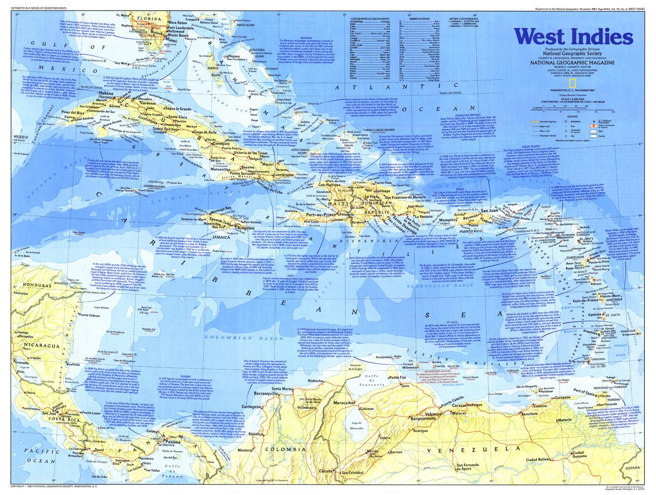
A vibrant and insightful exploration of the Caribbean, West Indies reveals the rich cultural tapestry and complex history of the island nations scattered across the Caribbean Sea. Published by National Geographic in November 1987 as part of the Making of America series, this map connects geography with centuries of exploration, colonisation, and cultural exchange.
Issued alongside the feature articles “Searching for Columbus’s Lost Colony: La Navidad” and “Haiti – Against All Odds,” it provides a deeper context to the region’s past and present.
Why This Map Stands Out
A culturally rich regional focus
Explores one of the most diverse regions in the Americas.
Part of the Making of America series
Blends historical narrative with geographic clarity.
Strong historical context
Links exploration, colonisation, and modern identity.
Balanced and educational
Presents the Caribbean as both a historical crossroads and living culture.
A visually engaging wall map
Ideal for both study and display.
🗺️ What the Map Shows
- The island groups of the West Indies across the Caribbean Sea
- Major islands including Cuba, Hispaniola, Jamaica, and Puerto Rico
- Colonial routes and historical connections across the region
- Geographic relationships between islands and surrounding seas
- Cultural and historical context tied to European exploration
- A regional framework linking trade, migration, and identity
📐 Size & Format
687 mm (W) × 519 mm (H)
Landscape orientation
A practical format ideal for:
- Classrooms and history education
- Home offices and studies
- Libraries and cultural displays
- Interiors inspired by Caribbean heritage
✨ Premium Finishes
| Format | Description |
|---|---|
| 📜 Paper (160 gsm) | Heavyweight matte-coated paper—ideal for framing. Preserves clarity and historical detail. |
| 🧼 Laminated (Encapsulated) | Sealed in 2 × 80-micron gloss laminate. Durable, wipe-clean, and suitable for reference use. |
| 🪵 Laminated + Timber Hang Rails | Laminated map mounted with lacquered natural timber rails and hanging cord—ready to display. |
| 🖼️ Canvas (395 gsm HP Professional Matte) | Printed with archival pigment inks. Adds depth and a refined finish. |
| 🪵 Canvas + Timber Hang Rails | Canvas paired with timber rails for a gallery-style presentation. |
🔨 Please allow up to 10 working days for professionally mounted hang-railed finishes.
📊 Specifications
| Feature | Detail |
|---|---|
| Title | Making of America: West Indies |
| Publisher | National Geographic |
| Published | 1987 |
| Scale | 1:4,395,000 |
| Dimensions | 687 mm × 519 mm |
| Orientation | Landscape |
| Map Type | Historical / Regional |
| Coverage | Caribbean (West Indies) |
| Collections | Central America & Caribbean, Historical, Regional |
| Materials | 160 gsm matte paper / 2 × 80-micron laminate / 395 gsm HP Professional Matte Canvas |
| Printing | Pigment-based, fade-resistant inks |
| Origin | Printed in Australia |
🎯 Ideal For
- Students and educators of Caribbean history and geography
- Enthusiasts of colonial history and exploration
- Collectors of National Geographic historical maps
- Interiors seeking a culturally rich display piece
- Gift buyers looking for a unique and educational map
🌴 A Crossroads of Cultures
The West Indies tell a story of connection:
- Islands shaped by exploration and trade routes
- Cultures formed through migration and exchange
- Histories marked by colonisation, resilience, and identity
- A region where geography and culture are inseparable
This map captures that story—offering a clear and compelling view of a region where history flows as freely as the surrounding seas.
🤝 Our Commitment
- Printed in Australia using archival-quality production
- Faithfully reproduced to preserve clarity and historical detail
- Premium materials selected for durability and longevity
- Each map is hand-checked before dispatch
- Carefully packaged for safe delivery
🚚 Delivery
- Paper, Laminated, Canvas (rolled): Dispatch within 1–2 business days
- Hang-Railed Maps: Made to order—allow up to 10 working days
- Packaging: Securely rolled in protective tubing
Explore the Caribbean through its history and geography—
a map that brings the West Indies into rich, cultural focus.
👉 Order now and add a vibrant regional story to your wall.
Original: $57.20
-65%$57.20
$20.02Product Information
Product Information
Shipping & Returns
Shipping & Returns
Description
Historical Regional Map | Caribbean Cultures, Colonisation & Change | Wall Format (687 × 519 mm) | Premium Finishes
A vibrant and insightful exploration of the Caribbean, West Indies reveals the rich cultural tapestry and complex history of the island nations scattered across the Caribbean Sea. Published by National Geographic in November 1987 as part of the Making of America series, this map connects geography with centuries of exploration, colonisation, and cultural exchange.
Issued alongside the feature articles “Searching for Columbus’s Lost Colony: La Navidad” and “Haiti – Against All Odds,” it provides a deeper context to the region’s past and present.
Why This Map Stands Out
A culturally rich regional focus
Explores one of the most diverse regions in the Americas.
Part of the Making of America series
Blends historical narrative with geographic clarity.
Strong historical context
Links exploration, colonisation, and modern identity.
Balanced and educational
Presents the Caribbean as both a historical crossroads and living culture.
A visually engaging wall map
Ideal for both study and display.
🗺️ What the Map Shows
- The island groups of the West Indies across the Caribbean Sea
- Major islands including Cuba, Hispaniola, Jamaica, and Puerto Rico
- Colonial routes and historical connections across the region
- Geographic relationships between islands and surrounding seas
- Cultural and historical context tied to European exploration
- A regional framework linking trade, migration, and identity
📐 Size & Format
687 mm (W) × 519 mm (H)
Landscape orientation
A practical format ideal for:
- Classrooms and history education
- Home offices and studies
- Libraries and cultural displays
- Interiors inspired by Caribbean heritage
✨ Premium Finishes
| Format | Description |
|---|---|
| 📜 Paper (160 gsm) | Heavyweight matte-coated paper—ideal for framing. Preserves clarity and historical detail. |
| 🧼 Laminated (Encapsulated) | Sealed in 2 × 80-micron gloss laminate. Durable, wipe-clean, and suitable for reference use. |
| 🪵 Laminated + Timber Hang Rails | Laminated map mounted with lacquered natural timber rails and hanging cord—ready to display. |
| 🖼️ Canvas (395 gsm HP Professional Matte) | Printed with archival pigment inks. Adds depth and a refined finish. |
| 🪵 Canvas + Timber Hang Rails | Canvas paired with timber rails for a gallery-style presentation. |
🔨 Please allow up to 10 working days for professionally mounted hang-railed finishes.
📊 Specifications
| Feature | Detail |
|---|---|
| Title | Making of America: West Indies |
| Publisher | National Geographic |
| Published | 1987 |
| Scale | 1:4,395,000 |
| Dimensions | 687 mm × 519 mm |
| Orientation | Landscape |
| Map Type | Historical / Regional |
| Coverage | Caribbean (West Indies) |
| Collections | Central America & Caribbean, Historical, Regional |
| Materials | 160 gsm matte paper / 2 × 80-micron laminate / 395 gsm HP Professional Matte Canvas |
| Printing | Pigment-based, fade-resistant inks |
| Origin | Printed in Australia |
🎯 Ideal For
- Students and educators of Caribbean history and geography
- Enthusiasts of colonial history and exploration
- Collectors of National Geographic historical maps
- Interiors seeking a culturally rich display piece
- Gift buyers looking for a unique and educational map
🌴 A Crossroads of Cultures
The West Indies tell a story of connection:
- Islands shaped by exploration and trade routes
- Cultures formed through migration and exchange
- Histories marked by colonisation, resilience, and identity
- A region where geography and culture are inseparable
This map captures that story—offering a clear and compelling view of a region where history flows as freely as the surrounding seas.
🤝 Our Commitment
- Printed in Australia using archival-quality production
- Faithfully reproduced to preserve clarity and historical detail
- Premium materials selected for durability and longevity
- Each map is hand-checked before dispatch
- Carefully packaged for safe delivery
🚚 Delivery
- Paper, Laminated, Canvas (rolled): Dispatch within 1–2 business days
- Hang-Railed Maps: Made to order—allow up to 10 working days
- Packaging: Securely rolled in protective tubing
Explore the Caribbean through its history and geography—
a map that brings the West Indies into rich, cultural focus.
👉 Order now and add a vibrant regional story to your wall.


