Making of America, West Indies Theme - Published 1987 by National Geographic
Historical & Thematic Map | Caribbean Contrasts & Cultural Legacy | Wall Format (687 × 519 mm) | Premium Finishes
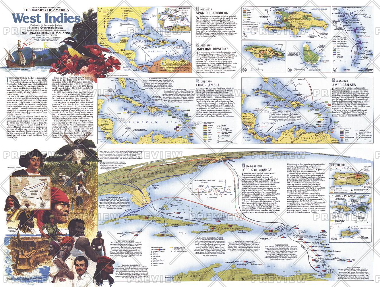
A powerful companion to the West Indies map, this Theme Map (Side Two) explores the Caribbean as a region of beauty, complexity, and profound historical depth. Published by National Geographic in November 1987 as part of the Making of America series, it presents a layered narrative of the islands shaped by exploration, colonisation, and cultural exchange.
From tropical coastlines to the enduring legacies of slavery and empire, this map reveals the forces that have defined the West Indies across centuries.
Why This Map Stands Out
A deeper historical lens
Expands on the regional map with detailed thematic insight.
Part of a two-map set
Designed as Side Two, complementing the primary West Indies map.
Balanced and thought-provoking
Explores both the beauty and the difficult history of the Caribbean.
Rich educational content
Presents complex themes in a clear, visual format.
A compelling wall map
Ideal for study, reflection, and display.
🗺️ What the Map Shows
- A thematic exploration of the Caribbean islands
- The legacy of European exploration and colonisation
- The impact of slavery, plantation economies, and trade
- Cultural diversity shaped by migration and exchange
- Regional connections across islands and sea routes
- A broader understanding of how history has shaped modern Caribbean identity
📐 Size & Format
687 mm (W) × 519 mm (H)
Landscape orientation
A practical format ideal for:
- Classrooms and history education
- Home offices and studies
- Libraries and cultural displays
- Pairing with the companion West Indies map
✨ Premium Finishes
| Format | Description |
|---|---|
| 📜 Paper (160 gsm) | Heavyweight matte-coated paper—ideal for framing. Preserves clarity across thematic content. |
| 🧼 Laminated (Encapsulated) | Sealed in 2 × 80-micron gloss laminate. Durable, wipe-clean, and suitable for reference use. |
| 🪵 Laminated + Timber Hang Rails | Laminated map mounted with lacquered natural timber rails and hanging cord—ready to display. |
| 🖼️ Canvas (395 gsm HP Professional Matte) | Printed with archival pigment inks. Adds depth and visual richness. |
| 🪵 Canvas + Timber Hang Rails | Canvas paired with timber rails for a refined, gallery-style presentation. |
🔨 Please allow up to 10 working days for professionally mounted hang-railed finishes.
📊 Specifications
| Feature | Detail |
|---|---|
| Title | Making of America: West Indies — Theme Map |
| Publisher | National Geographic |
| Published | 1987 |
| Dimensions | 687 mm × 519 mm |
| Orientation | Landscape |
| Map Type | Historical / Thematic |
| Coverage | Caribbean (West Indies) |
| Collections | North America, Historical |
| Materials | 160 gsm matte paper / 2 × 80-micron laminate / 395 gsm HP Professional Matte Canvas |
| Printing | Pigment-based, fade-resistant inks |
| Origin | Printed in Australia |
🎯 Ideal For
- Students and educators of Caribbean and colonial history
- Those exploring the social and cultural evolution of the West Indies
- Collectors of National Geographic historical series maps
- Interiors seeking a thought-provoking display piece
- Gift buyers looking for a meaningful companion map
🌴 Beauty and Complexity
The Caribbean is a region of contrasts:
- Lush tropical landscapes and island beauty
- Histories shaped by exploration, trade, and empire
- Legacies of hardship alongside resilience and cultural richness
- A region where past and present remain deeply connected
This map captures that duality—offering a nuanced view of a place where natural beauty and human history are inseparable.
🤝 Our Commitment
- Printed in Australia using archival-quality production
- Faithfully reproduced to preserve clarity and historical detail
- Premium materials selected for durability and longevity
- Each map is hand-checked before dispatch
- Carefully packaged for safe delivery
🚚 Delivery
- Paper, Laminated, Canvas (rolled): Dispatch within 1–2 business days
- Hang-Railed Maps: Made to order—allow up to 10 working days
- Packaging: Securely rolled in protective tubing
Complete the Caribbean story—
a map that brings history, culture, and complexity into focus.
👉 Order now and pair it with the companion map for a full regional narrative.
Original: $57.20
-65%$57.20
$20.02Product Information
Product Information
Shipping & Returns
Shipping & Returns
Description
Historical & Thematic Map | Caribbean Contrasts & Cultural Legacy | Wall Format (687 × 519 mm) | Premium Finishes
A powerful companion to the West Indies map, this Theme Map (Side Two) explores the Caribbean as a region of beauty, complexity, and profound historical depth. Published by National Geographic in November 1987 as part of the Making of America series, it presents a layered narrative of the islands shaped by exploration, colonisation, and cultural exchange.
From tropical coastlines to the enduring legacies of slavery and empire, this map reveals the forces that have defined the West Indies across centuries.
Why This Map Stands Out
A deeper historical lens
Expands on the regional map with detailed thematic insight.
Part of a two-map set
Designed as Side Two, complementing the primary West Indies map.
Balanced and thought-provoking
Explores both the beauty and the difficult history of the Caribbean.
Rich educational content
Presents complex themes in a clear, visual format.
A compelling wall map
Ideal for study, reflection, and display.
🗺️ What the Map Shows
- A thematic exploration of the Caribbean islands
- The legacy of European exploration and colonisation
- The impact of slavery, plantation economies, and trade
- Cultural diversity shaped by migration and exchange
- Regional connections across islands and sea routes
- A broader understanding of how history has shaped modern Caribbean identity
📐 Size & Format
687 mm (W) × 519 mm (H)
Landscape orientation
A practical format ideal for:
- Classrooms and history education
- Home offices and studies
- Libraries and cultural displays
- Pairing with the companion West Indies map
✨ Premium Finishes
| Format | Description |
|---|---|
| 📜 Paper (160 gsm) | Heavyweight matte-coated paper—ideal for framing. Preserves clarity across thematic content. |
| 🧼 Laminated (Encapsulated) | Sealed in 2 × 80-micron gloss laminate. Durable, wipe-clean, and suitable for reference use. |
| 🪵 Laminated + Timber Hang Rails | Laminated map mounted with lacquered natural timber rails and hanging cord—ready to display. |
| 🖼️ Canvas (395 gsm HP Professional Matte) | Printed with archival pigment inks. Adds depth and visual richness. |
| 🪵 Canvas + Timber Hang Rails | Canvas paired with timber rails for a refined, gallery-style presentation. |
🔨 Please allow up to 10 working days for professionally mounted hang-railed finishes.
📊 Specifications
| Feature | Detail |
|---|---|
| Title | Making of America: West Indies — Theme Map |
| Publisher | National Geographic |
| Published | 1987 |
| Dimensions | 687 mm × 519 mm |
| Orientation | Landscape |
| Map Type | Historical / Thematic |
| Coverage | Caribbean (West Indies) |
| Collections | North America, Historical |
| Materials | 160 gsm matte paper / 2 × 80-micron laminate / 395 gsm HP Professional Matte Canvas |
| Printing | Pigment-based, fade-resistant inks |
| Origin | Printed in Australia |
🎯 Ideal For
- Students and educators of Caribbean and colonial history
- Those exploring the social and cultural evolution of the West Indies
- Collectors of National Geographic historical series maps
- Interiors seeking a thought-provoking display piece
- Gift buyers looking for a meaningful companion map
🌴 Beauty and Complexity
The Caribbean is a region of contrasts:
- Lush tropical landscapes and island beauty
- Histories shaped by exploration, trade, and empire
- Legacies of hardship alongside resilience and cultural richness
- A region where past and present remain deeply connected
This map captures that duality—offering a nuanced view of a place where natural beauty and human history are inseparable.
🤝 Our Commitment
- Printed in Australia using archival-quality production
- Faithfully reproduced to preserve clarity and historical detail
- Premium materials selected for durability and longevity
- Each map is hand-checked before dispatch
- Carefully packaged for safe delivery
🚚 Delivery
- Paper, Laminated, Canvas (rolled): Dispatch within 1–2 business days
- Hang-Railed Maps: Made to order—allow up to 10 working days
- Packaging: Securely rolled in protective tubing
Complete the Caribbean story—
a map that brings history, culture, and complexity into focus.
👉 Order now and pair it with the companion map for a full regional narrative.


