Making of Canada, Atlantic Canada - Published 1993 by National Geographic
Historical Regional Map | Maritime Provinces & Coastal Heritage | Wall Format (683 × 519 mm) | Premium Finishes
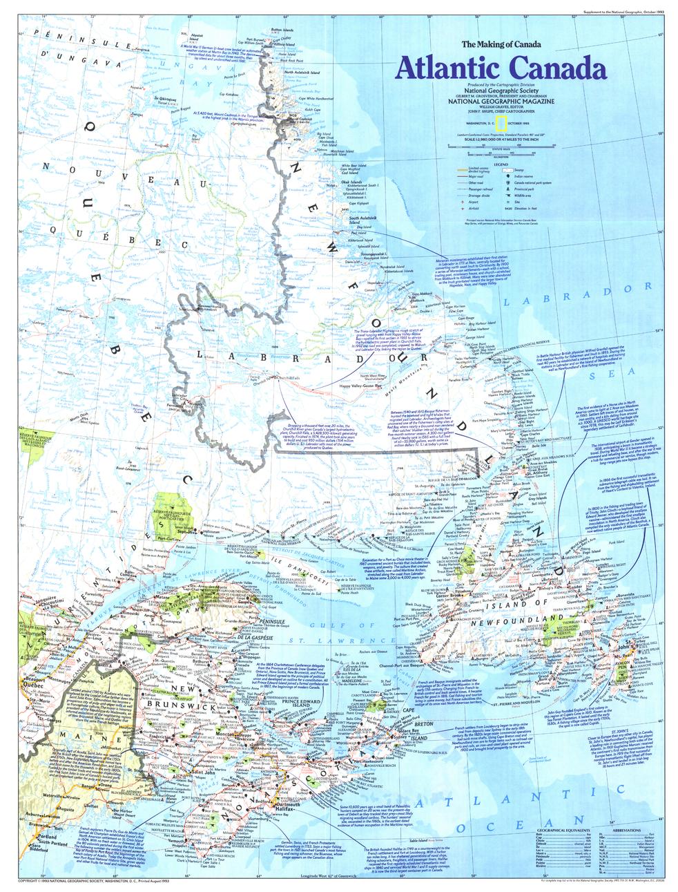
A beautifully composed exploration of Canada’s eastern edge, Atlantic Canada captures the landscapes, cultures, and history of the nation’s maritime provinces. Published by National Geographic in October 1993 as part of the Making of Canada series, this map blends geographic clarity with historical depth—revealing a region shaped by ocean, climate, and tradition.
From rugged coastlines to vibrant communities, it presents a compelling view of the provinces that define Canada’s Atlantic frontier.
Why This Map Stands Out
A maritime perspective
Explores the easternmost region of North America with a strong coastal focus.
Part of the Making of Canada series
Combines storytelling with precise cartography.
Rich cultural context
Highlights the diversity and heritage of Atlantic communities.
Balanced and educational
Links geography with history and regional identity.
A refined wall map
Ideal for both study and display.
🗺️ What the Map Shows
- The Atlantic provinces of Canada, including:
- Nova Scotia
- New Brunswick
- Prince Edward Island
- Newfoundland and Labrador
- Coastal geography, including bays, inlets, and offshore islands
- Cities, towns, and key settlements across the region
- Historical context tied to settlement, trade, and maritime life
- A regional framework connecting land, sea, and culture
📐 Size & Format
683 mm (H) × 519 mm (W)
Portrait orientation
A practical format ideal for:
- Classrooms and geography education
- Home offices and studies
- Libraries and cultural displays
- Interiors inspired by coastal and maritime themes
✨ Premium Finishes
| Format | Description |
|---|---|
| 📜 Paper (160 gsm) | Heavyweight matte-coated paper—ideal for framing. Preserves clarity and fine detail. |
| 🧼 Laminated (Encapsulated) | Sealed in 2 × 80-micron gloss laminate. Durable, wipe-clean, and suitable for reference use. |
| 🪵 Laminated + Timber Hang Rails | Laminated map mounted with lacquered natural timber rails and hanging cord—ready to display. |
| 🖼️ Canvas (395 gsm HP Professional Matte) | Printed with archival pigment inks. Adds depth and a refined finish. |
| 🪵 Canvas + Timber Hang Rails | Canvas paired with timber rails for a gallery-style presentation. |
🔨 Please allow up to 10 working days for professionally mounted hang-railed finishes.
📊 Specifications
| Feature | Detail |
|---|---|
| Title | Making of Canada: Atlantic Canada |
| Publisher | National Geographic |
| Published | 1993 |
| Scale | 1:2,980,000 |
| Dimensions | 683 mm × 519 mm |
| Orientation | Landscape |
| Map Type | Historical / Regional |
| Coverage | Atlantic Canada |
| Collections | Canada, Historical |
| Materials | 160 gsm matte paper / 2 × 80-micron laminate / 395 gsm HP Professional Matte Canvas |
| Printing | Pigment-based, fade-resistant inks |
| Origin | Printed in Australia |
🎯 Ideal For
- Students and educators of Canadian geography and history
- Enthusiasts of maritime culture and coastal regions
- Collectors of National Geographic historical maps
- Interiors seeking a coastal or heritage-inspired display piece
- Gift buyers looking for a distinctive regional map
🌊 Canada’s Atlantic Edge
Atlantic Canada is a region defined by:
- Rugged coastlines shaped by the North Atlantic
- Deep-rooted maritime traditions and communities
- Cultural diversity influenced by European settlement
- Landscapes where ocean and land are inseparable
This map captures that identity—offering a clear and compelling view of a region where history and the sea are forever intertwined.
🤝 Our Commitment
- Printed in Australia using archival-quality production
- Faithfully reproduced to preserve clarity and historical detail
- Premium materials selected for durability and longevity
- Each map is hand-checked before dispatch
- Carefully packaged for safe delivery
🚚 Delivery
- Paper, Laminated, Canvas (rolled): Dispatch within 1–2 business days
- Hang-Railed Maps: Made to order—allow up to 10 working days
- Packaging: Securely rolled in protective tubing
Explore Canada’s maritime frontier—
a map that brings Atlantic Canada’s landscapes and culture into focus.
👉 Order now and add a coastal perspective to your wall.
Original: $57.20
-65%$57.20
$20.02Product Information
Product Information
Shipping & Returns
Shipping & Returns
Description
Historical Regional Map | Maritime Provinces & Coastal Heritage | Wall Format (683 × 519 mm) | Premium Finishes
A beautifully composed exploration of Canada’s eastern edge, Atlantic Canada captures the landscapes, cultures, and history of the nation’s maritime provinces. Published by National Geographic in October 1993 as part of the Making of Canada series, this map blends geographic clarity with historical depth—revealing a region shaped by ocean, climate, and tradition.
From rugged coastlines to vibrant communities, it presents a compelling view of the provinces that define Canada’s Atlantic frontier.
Why This Map Stands Out
A maritime perspective
Explores the easternmost region of North America with a strong coastal focus.
Part of the Making of Canada series
Combines storytelling with precise cartography.
Rich cultural context
Highlights the diversity and heritage of Atlantic communities.
Balanced and educational
Links geography with history and regional identity.
A refined wall map
Ideal for both study and display.
🗺️ What the Map Shows
- The Atlantic provinces of Canada, including:
- Nova Scotia
- New Brunswick
- Prince Edward Island
- Newfoundland and Labrador
- Coastal geography, including bays, inlets, and offshore islands
- Cities, towns, and key settlements across the region
- Historical context tied to settlement, trade, and maritime life
- A regional framework connecting land, sea, and culture
📐 Size & Format
683 mm (H) × 519 mm (W)
Portrait orientation
A practical format ideal for:
- Classrooms and geography education
- Home offices and studies
- Libraries and cultural displays
- Interiors inspired by coastal and maritime themes
✨ Premium Finishes
| Format | Description |
|---|---|
| 📜 Paper (160 gsm) | Heavyweight matte-coated paper—ideal for framing. Preserves clarity and fine detail. |
| 🧼 Laminated (Encapsulated) | Sealed in 2 × 80-micron gloss laminate. Durable, wipe-clean, and suitable for reference use. |
| 🪵 Laminated + Timber Hang Rails | Laminated map mounted with lacquered natural timber rails and hanging cord—ready to display. |
| 🖼️ Canvas (395 gsm HP Professional Matte) | Printed with archival pigment inks. Adds depth and a refined finish. |
| 🪵 Canvas + Timber Hang Rails | Canvas paired with timber rails for a gallery-style presentation. |
🔨 Please allow up to 10 working days for professionally mounted hang-railed finishes.
📊 Specifications
| Feature | Detail |
|---|---|
| Title | Making of Canada: Atlantic Canada |
| Publisher | National Geographic |
| Published | 1993 |
| Scale | 1:2,980,000 |
| Dimensions | 683 mm × 519 mm |
| Orientation | Landscape |
| Map Type | Historical / Regional |
| Coverage | Atlantic Canada |
| Collections | Canada, Historical |
| Materials | 160 gsm matte paper / 2 × 80-micron laminate / 395 gsm HP Professional Matte Canvas |
| Printing | Pigment-based, fade-resistant inks |
| Origin | Printed in Australia |
🎯 Ideal For
- Students and educators of Canadian geography and history
- Enthusiasts of maritime culture and coastal regions
- Collectors of National Geographic historical maps
- Interiors seeking a coastal or heritage-inspired display piece
- Gift buyers looking for a distinctive regional map
🌊 Canada’s Atlantic Edge
Atlantic Canada is a region defined by:
- Rugged coastlines shaped by the North Atlantic
- Deep-rooted maritime traditions and communities
- Cultural diversity influenced by European settlement
- Landscapes where ocean and land are inseparable
This map captures that identity—offering a clear and compelling view of a region where history and the sea are forever intertwined.
🤝 Our Commitment
- Printed in Australia using archival-quality production
- Faithfully reproduced to preserve clarity and historical detail
- Premium materials selected for durability and longevity
- Each map is hand-checked before dispatch
- Carefully packaged for safe delivery
🚚 Delivery
- Paper, Laminated, Canvas (rolled): Dispatch within 1–2 business days
- Hang-Railed Maps: Made to order—allow up to 10 working days
- Packaging: Securely rolled in protective tubing
Explore Canada’s maritime frontier—
a map that brings Atlantic Canada’s landscapes and culture into focus.
👉 Order now and add a coastal perspective to your wall.


