Making of Canada, Atlantic Canada Theme - Published 1993 by National Geographic
Historical & Thematic Map | Exploration, Industry & Coastal Change | Wall Format (685 × 519 mm) | Premium Finishes
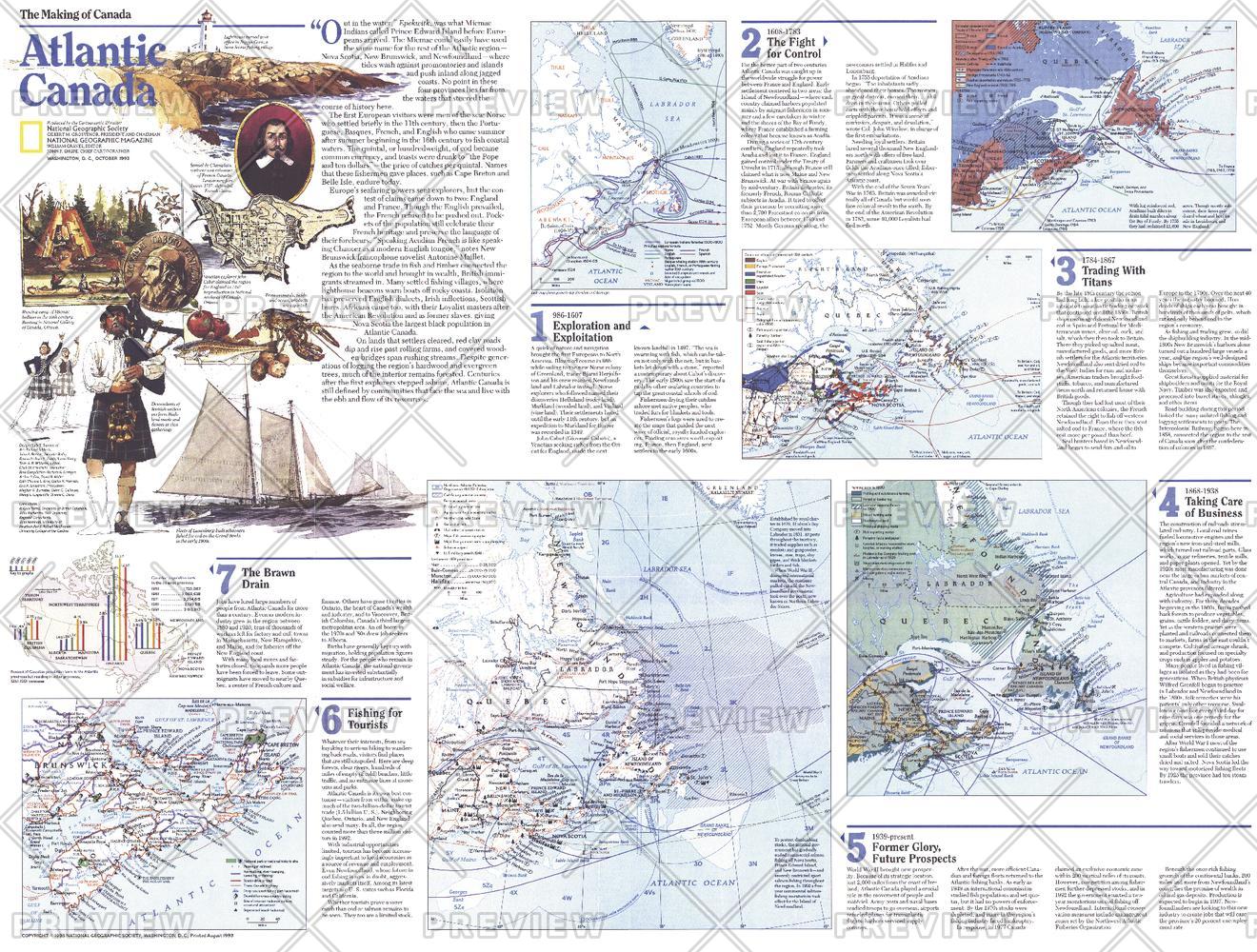
A rich companion to the Atlantic Canada map, this Theme Map (Side Two) explores the evolution of Canada’s maritime provinces through time. Published by National Geographic in October 1993 as part of the Making of Canada series, it presents a layered narrative of exploration, settlement, and economic change along the Atlantic edge.
From early voyages and coastal communities to shifting industries and modern tourism, this map reveals how Atlantic Canada has continually adapted to the forces of geography and economy.
Why This Map Stands Out
A deeper historical perspective
Expands on the regional map with detailed thematic insights.
Part of a two-map set
Designed as Side Two, complementing the primary Atlantic Canada map.
Multi-period storytelling
Traces exploration, settlement, and economic transformation.
Balanced and informative
Links traditional industries with emerging opportunities.
A compelling wall map
Ideal for study, reflection, and display.
🗺️ What the Map Shows
- A series of thematic maps detailing:
- Early European exploration and coastal discovery
- Patterns of settlement across the maritime provinces
- The historical importance of the fishing industry and its decline
- The rise of tourism as a modern economic driver
- Coastal geography shaping livelihoods and communities
- A regional overview connecting history, economy, and environment
📐 Size & Format
685 mm (W) × 519 mm (H)
Landscape orientation
A practical format ideal for:
- Classrooms and history education
- Home offices and studies
- Libraries and cultural displays
- Pairing with the companion Atlantic Canada map
✨ Premium Finishes
| Format | Description |
|---|---|
| 📜 Paper (160 gsm) | Heavyweight matte-coated paper—ideal for framing. Preserves clarity across thematic panels. |
| 🧼 Laminated (Encapsulated) | Sealed in 2 × 80-micron gloss laminate. Durable, wipe-clean, and suitable for reference use. |
| 🪵 Laminated + Timber Hang Rails | Laminated map mounted with lacquered natural timber rails and hanging cord—ready to display. |
| 🖼️ Canvas (395 gsm HP Professional Matte) | Printed with archival pigment inks. Adds depth and visual richness. |
| 🪵 Canvas + Timber Hang Rails | Canvas paired with timber rails for a refined, gallery-style presentation. |
🔨 Please allow up to 10 working days for professionally mounted hang-railed finishes.
📊 Specifications
| Feature | Detail |
|---|---|
| Title | Making of Canada: Atlantic Canada — Theme Map |
| Publisher | National Geographic |
| Published | 1993 |
| Dimensions | 685 mm × 519 mm |
| Orientation | Landscape |
| Map Type | Historical / Thematic |
| Coverage | Atlantic Canada |
| Collections | North America, Historical |
| Materials | 160 gsm matte paper / 2 × 80-micron laminate / 395 gsm HP Professional Matte Canvas |
| Printing | Pigment-based, fade-resistant inks |
| Origin | Printed in Australia |
🎯 Ideal For
- Students and educators of Canadian history and regional development
- Those interested in maritime economies and cultural change
- Collectors of National Geographic historical series maps
- Interiors seeking a thoughtful, heritage-focused display piece
- Gift buyers looking for a meaningful companion map
🌊 A Region in Transition
Atlantic Canada’s story is one of adaptation:
- Exploration shaping early coastal settlement
- Fishing industries sustaining generations
- Economic shifts redefining communities
- Tourism emerging as a new pathway forward
This map captures that evolution—offering a clear and compelling view of a region where tradition meets change along the Atlantic shore.
🤝 Our Commitment
- Printed in Australia using archival-quality production
- Faithfully reproduced to preserve clarity and historical detail
- Premium materials selected for durability and longevity
- Each map is hand-checked before dispatch
- Carefully packaged for safe delivery
🚚 Delivery
- Paper, Laminated, Canvas (rolled): Dispatch within 1–2 business days
- Hang-Railed Maps: Made to order—allow up to 10 working days
- Packaging: Securely rolled in protective tubing
Complete the Atlantic Canada story—
a map that brings history, industry, and coastal life into focus.
👉 Order now and pair it with the companion map for a full regional narrative.
Original: $57.20
-65%$57.20
$20.02Product Information
Product Information
Shipping & Returns
Shipping & Returns
Description
Historical & Thematic Map | Exploration, Industry & Coastal Change | Wall Format (685 × 519 mm) | Premium Finishes
A rich companion to the Atlantic Canada map, this Theme Map (Side Two) explores the evolution of Canada’s maritime provinces through time. Published by National Geographic in October 1993 as part of the Making of Canada series, it presents a layered narrative of exploration, settlement, and economic change along the Atlantic edge.
From early voyages and coastal communities to shifting industries and modern tourism, this map reveals how Atlantic Canada has continually adapted to the forces of geography and economy.
Why This Map Stands Out
A deeper historical perspective
Expands on the regional map with detailed thematic insights.
Part of a two-map set
Designed as Side Two, complementing the primary Atlantic Canada map.
Multi-period storytelling
Traces exploration, settlement, and economic transformation.
Balanced and informative
Links traditional industries with emerging opportunities.
A compelling wall map
Ideal for study, reflection, and display.
🗺️ What the Map Shows
- A series of thematic maps detailing:
- Early European exploration and coastal discovery
- Patterns of settlement across the maritime provinces
- The historical importance of the fishing industry and its decline
- The rise of tourism as a modern economic driver
- Coastal geography shaping livelihoods and communities
- A regional overview connecting history, economy, and environment
📐 Size & Format
685 mm (W) × 519 mm (H)
Landscape orientation
A practical format ideal for:
- Classrooms and history education
- Home offices and studies
- Libraries and cultural displays
- Pairing with the companion Atlantic Canada map
✨ Premium Finishes
| Format | Description |
|---|---|
| 📜 Paper (160 gsm) | Heavyweight matte-coated paper—ideal for framing. Preserves clarity across thematic panels. |
| 🧼 Laminated (Encapsulated) | Sealed in 2 × 80-micron gloss laminate. Durable, wipe-clean, and suitable for reference use. |
| 🪵 Laminated + Timber Hang Rails | Laminated map mounted with lacquered natural timber rails and hanging cord—ready to display. |
| 🖼️ Canvas (395 gsm HP Professional Matte) | Printed with archival pigment inks. Adds depth and visual richness. |
| 🪵 Canvas + Timber Hang Rails | Canvas paired with timber rails for a refined, gallery-style presentation. |
🔨 Please allow up to 10 working days for professionally mounted hang-railed finishes.
📊 Specifications
| Feature | Detail |
|---|---|
| Title | Making of Canada: Atlantic Canada — Theme Map |
| Publisher | National Geographic |
| Published | 1993 |
| Dimensions | 685 mm × 519 mm |
| Orientation | Landscape |
| Map Type | Historical / Thematic |
| Coverage | Atlantic Canada |
| Collections | North America, Historical |
| Materials | 160 gsm matte paper / 2 × 80-micron laminate / 395 gsm HP Professional Matte Canvas |
| Printing | Pigment-based, fade-resistant inks |
| Origin | Printed in Australia |
🎯 Ideal For
- Students and educators of Canadian history and regional development
- Those interested in maritime economies and cultural change
- Collectors of National Geographic historical series maps
- Interiors seeking a thoughtful, heritage-focused display piece
- Gift buyers looking for a meaningful companion map
🌊 A Region in Transition
Atlantic Canada’s story is one of adaptation:
- Exploration shaping early coastal settlement
- Fishing industries sustaining generations
- Economic shifts redefining communities
- Tourism emerging as a new pathway forward
This map captures that evolution—offering a clear and compelling view of a region where tradition meets change along the Atlantic shore.
🤝 Our Commitment
- Printed in Australia using archival-quality production
- Faithfully reproduced to preserve clarity and historical detail
- Premium materials selected for durability and longevity
- Each map is hand-checked before dispatch
- Carefully packaged for safe delivery
🚚 Delivery
- Paper, Laminated, Canvas (rolled): Dispatch within 1–2 business days
- Hang-Railed Maps: Made to order—allow up to 10 working days
- Packaging: Securely rolled in protective tubing
Complete the Atlantic Canada story—
a map that brings history, industry, and coastal life into focus.
👉 Order now and pair it with the companion map for a full regional narrative.


