Making of Canada, British Columbia - Published 1992 by National Geographic
Historical & Physical Wall Map | Mountains, Forests & Cultural Landscapes | Wall Format (685 × 518 mm) | Premium Finishes
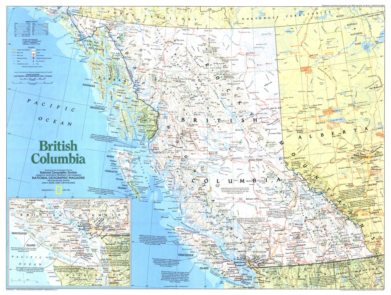
A striking portrayal of Canada’s Pacific province, British Columbia captures a land defined by dramatic terrain, abundant natural resources, and deep cultural heritage. Published by National Geographic as part of the Making of Canada series, this map blends physical geography with historical and cultural context.
From towering mountain ranges to dense coastal forests, it presents a vivid and detailed view of British Columbia—a region where landscape and identity are closely intertwined.
Why This Map Stands Out
A landscape-driven perspective
Highlights the rugged terrain and natural beauty of British Columbia.
Part of the Making of Canada series
Combines storytelling with precise cartography.
Rich cultural context
Includes Indigenous lands and the diversity of native cultures.
Protected landscapes in focus
Showcases national and provincial parks across the province.
A balanced wall map
Ideal for both study and display.
🗺️ What the Map Shows
- The full extent of British Columbia, including:
- Mountain ranges and highland terrain
- Forested regions and coastal environments
- National and provincial parks across the province
- Indigenous lands and reserves reflecting cultural heritage
- Cities, towns, and transport routes
- A regional framework linking natural resources, geography, and settlement
📐 Size & Format
685 mm (W) × 518 mm (H)
Landscape orientation
A practical format ideal for:
- Classrooms and geography education
- Home offices and studies
- Libraries and cultural displays
- Interiors inspired by natural landscapes
✨ Premium Finishes
| Format | Description |
|---|---|
| 📜 Paper (160 gsm) | Heavyweight matte-coated paper—ideal for framing. Preserves terrain detail and clarity. |
| 🧼 Laminated (Encapsulated) | Sealed in 2 × 80-micron gloss laminate. Durable, wipe-clean, and suitable for reference use. |
| 🪵 Laminated + Timber Hang Rails | Laminated map mounted with lacquered natural timber rails and hanging cord—ready to display. |
| 🖼️ Canvas (395 gsm HP Professional Matte) | Printed with archival pigment inks. Enhances depth and shaded relief. |
| 🪵 Canvas + Timber Hang Rails | Canvas paired with timber rails for a refined, gallery-style presentation. |
🔨 Please allow up to 10 working days for professionally mounted hang-railed finishes.
📊 Specifications
| Feature | Detail |
|---|---|
| Title | Making of Canada: British Columbia |
| Publisher | National Geographic |
| Published | 1992 |
| Scale | 1:2,914,000 |
| Dimensions | 685 mm × 518 mm |
| Orientation | Landscape |
| Map Type | Historical / Physical |
| Coverage | British Columbia, Canada |
| Collections | Canada, Historical, Physical |
| Materials | 160 gsm matte paper / 2 × 80-micron laminate / 395 gsm HP Professional Matte Canvas |
| Printing | Pigment-based, fade-resistant inks |
| Origin | Printed in Australia |
🎯 Ideal For
- Students and educators of Canadian geography and history
- Enthusiasts of mountain and forest landscapes
- Collectors of National Geographic historical maps
- Interiors seeking a nature-inspired display piece
- Gift buyers looking for a distinctive regional map
🌲 A Province of Scale and Diversity
British Columbia is defined by:
- Rugged mountain ranges and vast wilderness
- Forests rich in natural resources
- Coastlines shaped by the Pacific Ocean
- Indigenous cultures deeply connected to the land
This map captures that diversity—offering a clear and compelling view of a province where nature, culture, and history meet.
🤝 Our Commitment
- Printed in Australia using archival-quality production
- Faithfully reproduced to preserve clarity and detail
- Premium materials selected for durability and longevity
- Each map is hand-checked before dispatch
- Carefully packaged for safe delivery
🚚 Delivery
- Paper, Laminated, Canvas (rolled): Dispatch within 1–2 business days
- Hang-Railed Maps: Made to order—allow up to 10 working days
- Packaging: Securely rolled in protective tubing
Explore Canada’s Pacific frontier—
a map that brings British Columbia’s landscapes and heritage into focus.
👉 Order now and add a striking natural perspective to your wall.
Original: $57.20
-65%$57.20
$20.02Product Information
Product Information
Shipping & Returns
Shipping & Returns
Description
Historical & Physical Wall Map | Mountains, Forests & Cultural Landscapes | Wall Format (685 × 518 mm) | Premium Finishes
A striking portrayal of Canada’s Pacific province, British Columbia captures a land defined by dramatic terrain, abundant natural resources, and deep cultural heritage. Published by National Geographic as part of the Making of Canada series, this map blends physical geography with historical and cultural context.
From towering mountain ranges to dense coastal forests, it presents a vivid and detailed view of British Columbia—a region where landscape and identity are closely intertwined.
Why This Map Stands Out
A landscape-driven perspective
Highlights the rugged terrain and natural beauty of British Columbia.
Part of the Making of Canada series
Combines storytelling with precise cartography.
Rich cultural context
Includes Indigenous lands and the diversity of native cultures.
Protected landscapes in focus
Showcases national and provincial parks across the province.
A balanced wall map
Ideal for both study and display.
🗺️ What the Map Shows
- The full extent of British Columbia, including:
- Mountain ranges and highland terrain
- Forested regions and coastal environments
- National and provincial parks across the province
- Indigenous lands and reserves reflecting cultural heritage
- Cities, towns, and transport routes
- A regional framework linking natural resources, geography, and settlement
📐 Size & Format
685 mm (W) × 518 mm (H)
Landscape orientation
A practical format ideal for:
- Classrooms and geography education
- Home offices and studies
- Libraries and cultural displays
- Interiors inspired by natural landscapes
✨ Premium Finishes
| Format | Description |
|---|---|
| 📜 Paper (160 gsm) | Heavyweight matte-coated paper—ideal for framing. Preserves terrain detail and clarity. |
| 🧼 Laminated (Encapsulated) | Sealed in 2 × 80-micron gloss laminate. Durable, wipe-clean, and suitable for reference use. |
| 🪵 Laminated + Timber Hang Rails | Laminated map mounted with lacquered natural timber rails and hanging cord—ready to display. |
| 🖼️ Canvas (395 gsm HP Professional Matte) | Printed with archival pigment inks. Enhances depth and shaded relief. |
| 🪵 Canvas + Timber Hang Rails | Canvas paired with timber rails for a refined, gallery-style presentation. |
🔨 Please allow up to 10 working days for professionally mounted hang-railed finishes.
📊 Specifications
| Feature | Detail |
|---|---|
| Title | Making of Canada: British Columbia |
| Publisher | National Geographic |
| Published | 1992 |
| Scale | 1:2,914,000 |
| Dimensions | 685 mm × 518 mm |
| Orientation | Landscape |
| Map Type | Historical / Physical |
| Coverage | British Columbia, Canada |
| Collections | Canada, Historical, Physical |
| Materials | 160 gsm matte paper / 2 × 80-micron laminate / 395 gsm HP Professional Matte Canvas |
| Printing | Pigment-based, fade-resistant inks |
| Origin | Printed in Australia |
🎯 Ideal For
- Students and educators of Canadian geography and history
- Enthusiasts of mountain and forest landscapes
- Collectors of National Geographic historical maps
- Interiors seeking a nature-inspired display piece
- Gift buyers looking for a distinctive regional map
🌲 A Province of Scale and Diversity
British Columbia is defined by:
- Rugged mountain ranges and vast wilderness
- Forests rich in natural resources
- Coastlines shaped by the Pacific Ocean
- Indigenous cultures deeply connected to the land
This map captures that diversity—offering a clear and compelling view of a province where nature, culture, and history meet.
🤝 Our Commitment
- Printed in Australia using archival-quality production
- Faithfully reproduced to preserve clarity and detail
- Premium materials selected for durability and longevity
- Each map is hand-checked before dispatch
- Carefully packaged for safe delivery
🚚 Delivery
- Paper, Laminated, Canvas (rolled): Dispatch within 1–2 business days
- Hang-Railed Maps: Made to order—allow up to 10 working days
- Packaging: Securely rolled in protective tubing
Explore Canada’s Pacific frontier—
a map that brings British Columbia’s landscapes and heritage into focus.
👉 Order now and add a striking natural perspective to your wall.


