Making of Canada, British Columbia Theme - Published 1992 by National Geographic
Historical & Thematic Map | Exploration, Settlement & Modern Landscape | Wall Format (685 × 518 mm) | Premium Finishes
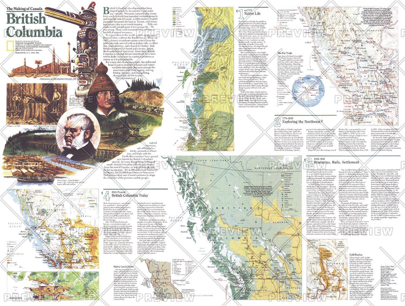
A rich companion to the British Columbia map, this Theme Map (Side Two) reveals the province’s journey from early exploration to its present-day identity. Published by National Geographic in April 1992 as part of the Making of Canada series, it presents a layered narrative of discovery, settlement, and development across one of Canada’s most dramatic regions.
Through a series of thematic maps, it connects the past with the present—showing how British Columbia evolved into a province defined by both natural grandeur and cultural depth.
Why This Map Stands Out
A deeper historical perspective
Expands on the regional map with detailed thematic insights.
Part of a two-map set
Designed as Side Two, complementing the primary British Columbia map.
Multi-period storytelling
Traces exploration, settlement, and modern development.
Balanced and engaging
Links early history with the contemporary landscape.
A refined wall map
Ideal for pairing or standalone display.
🗺️ What the Map Shows
- A collection of thematic maps detailing:
- Early exploration routes and coastal discovery
- Patterns of settlement and expansion across the province
- The development of communities shaped by geography and resources
- A transition from frontier landscapes to modern regions
- Key geographic features influencing historical movement and growth
- A cohesive view linking history, environment, and present-day British Columbia
📐 Size & Format
685 mm (W) × 518 mm (H)
Landscape orientation
A practical format ideal for:
- Classrooms and history education
- Home offices and studies
- Libraries and heritage displays
- Pairing with the companion British Columbia map
✨ Premium Finishes
| Format | Description |
|---|---|
| 📜 Paper (160 gsm) | Heavyweight matte-coated paper—ideal for framing. Preserves clarity across thematic panels. |
| 🧼 Laminated (Encapsulated) | Sealed in 2 × 80-micron gloss laminate. Durable, wipe-clean, and suitable for reference use. |
| 🪵 Laminated + Timber Hang Rails | Laminated map mounted with lacquered natural timber rails and hanging cord—ready to display. |
| 🖼️ Canvas (395 gsm HP Professional Matte) | Printed with archival pigment inks. Adds depth and visual richness. |
| 🪵 Canvas + Timber Hang Rails | Canvas paired with timber rails for a refined, gallery-style presentation. |
🔨 Please allow up to 10 working days for professionally mounted hang-railed finishes.
📊 Specifications
| Feature | Detail |
|---|---|
| Title | Making of Canada: British Columbia — Theme Map |
| Publisher | National Geographic |
| Published | 1992 |
| Dimensions | 685 mm × 518 mm |
| Orientation | Landscape |
| Map Type | Historical / Thematic |
| Coverage | British Columbia, Canada |
| Collections | North America, Historical |
| Materials | 160 gsm matte paper / 2 × 80-micron laminate / 395 gsm HP Professional Matte Canvas |
| Printing | Pigment-based, fade-resistant inks |
| Origin | Printed in Australia |
🎯 Ideal For
- Students and educators of Canadian history and regional development
- Those interested in exploration and settlement of the Pacific Northwest
- Collectors of National Geographic historical series maps
- Interiors seeking a heritage-focused display piece
- Gift buyers looking for a meaningful companion map
🌄 From Exploration to Identity
British Columbia’s story is one of transformation:
- Early exploration along rugged coasts and inland routes
- Settlement shaped by geography and natural resources
- Growth into a modern province with global significance
- A landscape where history and environment remain deeply connected
This map captures that journey—offering a clear and compelling view of how the province has evolved from frontier to modern landscape.
🤝 Our Commitment
- Printed in Australia using archival-quality production
- Faithfully reproduced to preserve clarity and historical detail
- Premium materials selected for durability and longevity
- Each map is hand-checked before dispatch
- Carefully packaged for safe delivery
🚚 Delivery
- Paper, Laminated, Canvas (rolled): Dispatch within 1–2 business days
- Hang-Railed Maps: Made to order—allow up to 10 working days
- Packaging: Securely rolled in protective tubing
Complete the British Columbia story—
a map that brings exploration, settlement, and modern identity into focus.
👉 Order now and pair it with the companion map for a full regional narrative.
Original: $57.20
-65%$57.20
$20.02Product Information
Product Information
Shipping & Returns
Shipping & Returns
Description
Historical & Thematic Map | Exploration, Settlement & Modern Landscape | Wall Format (685 × 518 mm) | Premium Finishes
A rich companion to the British Columbia map, this Theme Map (Side Two) reveals the province’s journey from early exploration to its present-day identity. Published by National Geographic in April 1992 as part of the Making of Canada series, it presents a layered narrative of discovery, settlement, and development across one of Canada’s most dramatic regions.
Through a series of thematic maps, it connects the past with the present—showing how British Columbia evolved into a province defined by both natural grandeur and cultural depth.
Why This Map Stands Out
A deeper historical perspective
Expands on the regional map with detailed thematic insights.
Part of a two-map set
Designed as Side Two, complementing the primary British Columbia map.
Multi-period storytelling
Traces exploration, settlement, and modern development.
Balanced and engaging
Links early history with the contemporary landscape.
A refined wall map
Ideal for pairing or standalone display.
🗺️ What the Map Shows
- A collection of thematic maps detailing:
- Early exploration routes and coastal discovery
- Patterns of settlement and expansion across the province
- The development of communities shaped by geography and resources
- A transition from frontier landscapes to modern regions
- Key geographic features influencing historical movement and growth
- A cohesive view linking history, environment, and present-day British Columbia
📐 Size & Format
685 mm (W) × 518 mm (H)
Landscape orientation
A practical format ideal for:
- Classrooms and history education
- Home offices and studies
- Libraries and heritage displays
- Pairing with the companion British Columbia map
✨ Premium Finishes
| Format | Description |
|---|---|
| 📜 Paper (160 gsm) | Heavyweight matte-coated paper—ideal for framing. Preserves clarity across thematic panels. |
| 🧼 Laminated (Encapsulated) | Sealed in 2 × 80-micron gloss laminate. Durable, wipe-clean, and suitable for reference use. |
| 🪵 Laminated + Timber Hang Rails | Laminated map mounted with lacquered natural timber rails and hanging cord—ready to display. |
| 🖼️ Canvas (395 gsm HP Professional Matte) | Printed with archival pigment inks. Adds depth and visual richness. |
| 🪵 Canvas + Timber Hang Rails | Canvas paired with timber rails for a refined, gallery-style presentation. |
🔨 Please allow up to 10 working days for professionally mounted hang-railed finishes.
📊 Specifications
| Feature | Detail |
|---|---|
| Title | Making of Canada: British Columbia — Theme Map |
| Publisher | National Geographic |
| Published | 1992 |
| Dimensions | 685 mm × 518 mm |
| Orientation | Landscape |
| Map Type | Historical / Thematic |
| Coverage | British Columbia, Canada |
| Collections | North America, Historical |
| Materials | 160 gsm matte paper / 2 × 80-micron laminate / 395 gsm HP Professional Matte Canvas |
| Printing | Pigment-based, fade-resistant inks |
| Origin | Printed in Australia |
🎯 Ideal For
- Students and educators of Canadian history and regional development
- Those interested in exploration and settlement of the Pacific Northwest
- Collectors of National Geographic historical series maps
- Interiors seeking a heritage-focused display piece
- Gift buyers looking for a meaningful companion map
🌄 From Exploration to Identity
British Columbia’s story is one of transformation:
- Early exploration along rugged coasts and inland routes
- Settlement shaped by geography and natural resources
- Growth into a modern province with global significance
- A landscape where history and environment remain deeply connected
This map captures that journey—offering a clear and compelling view of how the province has evolved from frontier to modern landscape.
🤝 Our Commitment
- Printed in Australia using archival-quality production
- Faithfully reproduced to preserve clarity and historical detail
- Premium materials selected for durability and longevity
- Each map is hand-checked before dispatch
- Carefully packaged for safe delivery
🚚 Delivery
- Paper, Laminated, Canvas (rolled): Dispatch within 1–2 business days
- Hang-Railed Maps: Made to order—allow up to 10 working days
- Packaging: Securely rolled in protective tubing
Complete the British Columbia story—
a map that brings exploration, settlement, and modern identity into focus.
👉 Order now and pair it with the companion map for a full regional narrative.


