Making of Canada, Ontario - Published 1996 by National Geographic
Historical Regional Map | Cities, Wilderness & Resource Landscapes | Wall Format (688 × 523 mm) | Premium Finishes
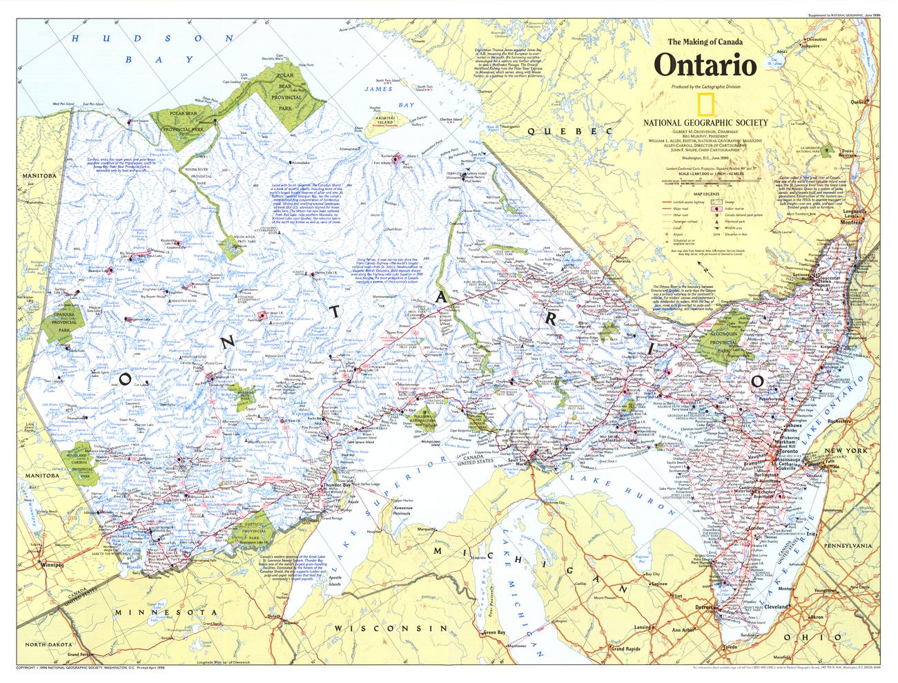
A compelling portrait of Canada’s most populous province, Ontario reveals a land of striking contrasts—where dense urban centres meet vast, uninhabited wilderness. Published by National Geographic in June 1996 as part of the Making of Canada series, this map blends geographic clarity with historical and economic context.
From the Great Lakes corridor to the remote northern interior, it presents a detailed and balanced view of Ontario—a province central to Canada’s identity and growth.
Why This Map Stands Out
A province of contrasts
Captures both Ontario’s major urban regions and its expansive wilderness.
Part of the Making of Canada series
Combines storytelling with precise cartography.
Rich informational depth
Highlights population centres, natural resources, and geographic features.
Economic and geographic insight
Reflects Ontario’s role as a hub of industry and mineral wealth.
A versatile wall map
Ideal for both study and display.
🗺️ What the Map Shows
- The full extent of Ontario, including:
- Major cities and urban corridors
- Northern wilderness and sparsely populated regions
- The Great Lakes system shaping settlement and transport
- Natural features including forests, lakes, and mineral-rich regions
- Key infrastructure and regional connections
- A framework linking population, resources, and geography
📐 Size & Format
688 mm (W) × 523 mm (H)
Landscape orientation
A practical, display-friendly format ideal for:
- Classrooms and geography education
- Home offices and studies
- Libraries and heritage displays
- Interiors inspired by Canadian landscapes
✨ Premium Finishes
| Format | Description |
|---|---|
| 📜 Paper (160 gsm) | Heavyweight matte-coated paper—ideal for framing. Preserves clarity and detail. |
| 🧼 Laminated (Encapsulated) | Sealed in 2 × 80-micron gloss laminate. Durable, wipe-clean, and suitable for reference use. |
| 🪵 Laminated + Timber Hang Rails | Laminated map mounted with lacquered natural timber rails and hanging cord—ready to display. |
| 🖼️ Canvas (395 gsm HP Professional Matte) | Printed with archival pigment inks. Adds depth and a refined finish. |
| 🪵 Canvas + Timber Hang Rails | Canvas paired with timber rails for a gallery-style presentation. |
🔨 Please allow up to 10 working days for professionally mounted hang-railed finishes.
📊 Specifications
| Feature | Detail |
|---|---|
| Title | Making of Canada: Ontario |
| Publisher | National Geographic |
| Published | 1996 |
| Scale | 1:2,667,000 |
| Dimensions | 688 mm × 523 mm |
| Orientation | Landscape |
| Map Type | Historical / Regional |
| Coverage | Ontario, Canada |
| Collections | Canada, Historical |
| Materials | 160 gsm matte paper / 2 × 80-micron laminate / 395 gsm HP Professional Matte Canvas |
| Printing | Pigment-based, fade-resistant inks |
| Origin | Printed in Australia |
🎯 Ideal For
- Students and educators of Canadian geography and history
- Those interested in urban development and natural resources
- Collectors of National Geographic historical maps
- Interiors seeking a balanced, region-focused display piece
- Gift buyers looking for a distinctive provincial map
🌊 A Province of Scale and Influence
Ontario is defined by diversity:
- Major cities driving Canada’s economy
- Vast northern landscapes rich in resources
- Lakes and waterways shaping transport and settlement
- A region where urban life meets wilderness
This map captures that balance—offering a clear and compelling view of a province where population, nature, and industry intersect.
🤝 Our Commitment
- Printed in Australia using archival-quality production
- Faithfully reproduced to preserve clarity and detail
- Premium materials selected for durability and longevity
- Each map is hand-checked before dispatch
- Carefully packaged for safe delivery
🚚 Delivery
- Paper, Laminated, Canvas (rolled): Dispatch within 1–2 business days
- Hang-Railed Maps: Made to order—allow up to 10 working days
- Packaging: Securely rolled in protective tubing
Explore Canada’s most dynamic province—
a map that brings Ontario’s landscapes and influence into focus.
👉 Order now and add a powerful Canadian perspective to your wall.
Original: $57.20
-65%$57.20
$20.02Product Information
Product Information
Shipping & Returns
Shipping & Returns
Description
Historical Regional Map | Cities, Wilderness & Resource Landscapes | Wall Format (688 × 523 mm) | Premium Finishes
A compelling portrait of Canada’s most populous province, Ontario reveals a land of striking contrasts—where dense urban centres meet vast, uninhabited wilderness. Published by National Geographic in June 1996 as part of the Making of Canada series, this map blends geographic clarity with historical and economic context.
From the Great Lakes corridor to the remote northern interior, it presents a detailed and balanced view of Ontario—a province central to Canada’s identity and growth.
Why This Map Stands Out
A province of contrasts
Captures both Ontario’s major urban regions and its expansive wilderness.
Part of the Making of Canada series
Combines storytelling with precise cartography.
Rich informational depth
Highlights population centres, natural resources, and geographic features.
Economic and geographic insight
Reflects Ontario’s role as a hub of industry and mineral wealth.
A versatile wall map
Ideal for both study and display.
🗺️ What the Map Shows
- The full extent of Ontario, including:
- Major cities and urban corridors
- Northern wilderness and sparsely populated regions
- The Great Lakes system shaping settlement and transport
- Natural features including forests, lakes, and mineral-rich regions
- Key infrastructure and regional connections
- A framework linking population, resources, and geography
📐 Size & Format
688 mm (W) × 523 mm (H)
Landscape orientation
A practical, display-friendly format ideal for:
- Classrooms and geography education
- Home offices and studies
- Libraries and heritage displays
- Interiors inspired by Canadian landscapes
✨ Premium Finishes
| Format | Description |
|---|---|
| 📜 Paper (160 gsm) | Heavyweight matte-coated paper—ideal for framing. Preserves clarity and detail. |
| 🧼 Laminated (Encapsulated) | Sealed in 2 × 80-micron gloss laminate. Durable, wipe-clean, and suitable for reference use. |
| 🪵 Laminated + Timber Hang Rails | Laminated map mounted with lacquered natural timber rails and hanging cord—ready to display. |
| 🖼️ Canvas (395 gsm HP Professional Matte) | Printed with archival pigment inks. Adds depth and a refined finish. |
| 🪵 Canvas + Timber Hang Rails | Canvas paired with timber rails for a gallery-style presentation. |
🔨 Please allow up to 10 working days for professionally mounted hang-railed finishes.
📊 Specifications
| Feature | Detail |
|---|---|
| Title | Making of Canada: Ontario |
| Publisher | National Geographic |
| Published | 1996 |
| Scale | 1:2,667,000 |
| Dimensions | 688 mm × 523 mm |
| Orientation | Landscape |
| Map Type | Historical / Regional |
| Coverage | Ontario, Canada |
| Collections | Canada, Historical |
| Materials | 160 gsm matte paper / 2 × 80-micron laminate / 395 gsm HP Professional Matte Canvas |
| Printing | Pigment-based, fade-resistant inks |
| Origin | Printed in Australia |
🎯 Ideal For
- Students and educators of Canadian geography and history
- Those interested in urban development and natural resources
- Collectors of National Geographic historical maps
- Interiors seeking a balanced, region-focused display piece
- Gift buyers looking for a distinctive provincial map
🌊 A Province of Scale and Influence
Ontario is defined by diversity:
- Major cities driving Canada’s economy
- Vast northern landscapes rich in resources
- Lakes and waterways shaping transport and settlement
- A region where urban life meets wilderness
This map captures that balance—offering a clear and compelling view of a province where population, nature, and industry intersect.
🤝 Our Commitment
- Printed in Australia using archival-quality production
- Faithfully reproduced to preserve clarity and detail
- Premium materials selected for durability and longevity
- Each map is hand-checked before dispatch
- Carefully packaged for safe delivery
🚚 Delivery
- Paper, Laminated, Canvas (rolled): Dispatch within 1–2 business days
- Hang-Railed Maps: Made to order—allow up to 10 working days
- Packaging: Securely rolled in protective tubing
Explore Canada’s most dynamic province—
a map that brings Ontario’s landscapes and influence into focus.
👉 Order now and add a powerful Canadian perspective to your wall.


