Making of Canada, Ontario Theme - Published 1996 by National Geographic
Historical & Thematic Map | Cities, Wilderness & Provincial Identity | Wall Format (688 × 523 mm) | Premium Finishes
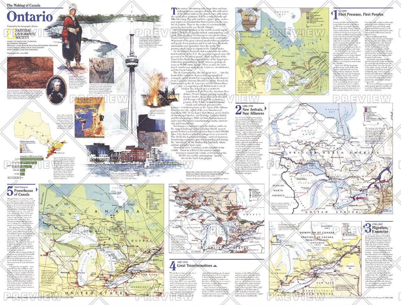
A compelling overview of Canada’s most dynamic province, Ontario — Theme Map (Side One) captures the balance between urban power and vast northern wilderness. Published by National Geographic in June 1996 as part of the Making of Canada series, this map provides a layered introduction to the province’s geography, population, and development.
Produced alongside a feature article on Toronto, it reflects the province’s role as both a cultural and economic centre—while remaining deeply connected to its expansive natural landscapes.
Why This Map Stands Out
A province of contrasts
Explores Ontario’s vibrant cities alongside its remote northern regions.
Part of a two-map set
Designed as Side One, introducing the province’s geography and identity.
Balanced thematic insight
Combines population, landscape, and regional structure.
Educational and accessible
Presents complex geography in a clear, visual format.
A refined wall map
Ideal for both standalone display and pairing with its companion.
🗺️ What the Map Shows
- The full extent of Ontario
- Major urban centres, including Toronto and surrounding regions
- The transition from densely populated south to sparsely inhabited north
- Boreal forests, lakes, and tundra landscapes
- Key geographic features shaping settlement and development
- A framework linking population, environment, and regional identity
📐 Size & Format
688 mm (W) × 523 mm (H)
Landscape orientation
A practical format ideal for:
- Classrooms and geography education
- Home offices and studies
- Libraries and heritage displays
- Pairing with the companion Ontario map
✨ Premium Finishes
| Format | Description |
|---|---|
| 📜 Paper (160 gsm) | Heavyweight matte-coated paper—ideal for framing. Preserves clarity across thematic detail. |
| 🧼 Laminated (Encapsulated) | Sealed in 2 × 80-micron gloss laminate. Durable, wipe-clean, and suitable for reference use. |
| 🪵 Laminated + Timber Hang Rails | Laminated map mounted with lacquered natural timber rails and hanging cord—ready to display. |
| 🖼️ Canvas (395 gsm HP Professional Matte) | Printed with archival pigment inks. Adds depth and a refined finish. |
| 🪵 Canvas + Timber Hang Rails | Canvas paired with timber rails for a gallery-style presentation. |
🔨 Please allow up to 10 working days for professionally mounted hang-railed finishes.
📊 Specifications
| Feature | Detail |
|---|---|
| Title | Making of Canada: Ontario — Theme Map |
| Publisher | National Geographic |
| Published | 1996 |
| Dimensions | 688 mm × 523 mm |
| Orientation | Landscape |
| Map Type | Historical / Thematic |
| Coverage | Ontario, Canada |
| Collections | North America, Historical |
| Materials | 160 gsm matte paper / 2 × 80-micron laminate / 395 gsm HP Professional Matte Canvas |
| Printing | Pigment-based, fade-resistant inks |
| Origin | Printed in Australia |
🎯 Ideal For
- Students and educators of Canadian geography and development
- Those interested in urbanisation and regional contrasts
- Collectors of National Geographic historical series maps
- Interiors seeking a balanced, educational display piece
- Gift buyers looking for a meaningful companion map
🌊 Where City Meets Wilderness
Ontario’s identity is shaped by contrast:
- Major cities driving culture and economy
- Vast northern landscapes rich in forests and lakes
- A province where population is concentrated yet space remains immense
- A region where modern life meets enduring natural systems
This map captures that balance—offering a clear view of a province where urban energy and wilderness scale coexist.
🤝 Our Commitment
- Printed in Australia using archival-quality production
- Faithfully reproduced to preserve clarity and detail
- Premium materials selected for durability and longevity
- Each map is hand-checked before dispatch
- Carefully packaged for safe delivery
🚚 Delivery
- Paper, Laminated, Canvas (rolled): Dispatch within 1–2 business days
- Hang-Railed Maps: Made to order—allow up to 10 working days
- Packaging: Securely rolled in protective tubing
Begin the Ontario story—
a map that brings geography, population, and identity into focus.
👉 Order now and complete the set with its companion map.
Original: $57.20
-65%$57.20
$20.02Product Information
Product Information
Shipping & Returns
Shipping & Returns
Description
Historical & Thematic Map | Cities, Wilderness & Provincial Identity | Wall Format (688 × 523 mm) | Premium Finishes
A compelling overview of Canada’s most dynamic province, Ontario — Theme Map (Side One) captures the balance between urban power and vast northern wilderness. Published by National Geographic in June 1996 as part of the Making of Canada series, this map provides a layered introduction to the province’s geography, population, and development.
Produced alongside a feature article on Toronto, it reflects the province’s role as both a cultural and economic centre—while remaining deeply connected to its expansive natural landscapes.
Why This Map Stands Out
A province of contrasts
Explores Ontario’s vibrant cities alongside its remote northern regions.
Part of a two-map set
Designed as Side One, introducing the province’s geography and identity.
Balanced thematic insight
Combines population, landscape, and regional structure.
Educational and accessible
Presents complex geography in a clear, visual format.
A refined wall map
Ideal for both standalone display and pairing with its companion.
🗺️ What the Map Shows
- The full extent of Ontario
- Major urban centres, including Toronto and surrounding regions
- The transition from densely populated south to sparsely inhabited north
- Boreal forests, lakes, and tundra landscapes
- Key geographic features shaping settlement and development
- A framework linking population, environment, and regional identity
📐 Size & Format
688 mm (W) × 523 mm (H)
Landscape orientation
A practical format ideal for:
- Classrooms and geography education
- Home offices and studies
- Libraries and heritage displays
- Pairing with the companion Ontario map
✨ Premium Finishes
| Format | Description |
|---|---|
| 📜 Paper (160 gsm) | Heavyweight matte-coated paper—ideal for framing. Preserves clarity across thematic detail. |
| 🧼 Laminated (Encapsulated) | Sealed in 2 × 80-micron gloss laminate. Durable, wipe-clean, and suitable for reference use. |
| 🪵 Laminated + Timber Hang Rails | Laminated map mounted with lacquered natural timber rails and hanging cord—ready to display. |
| 🖼️ Canvas (395 gsm HP Professional Matte) | Printed with archival pigment inks. Adds depth and a refined finish. |
| 🪵 Canvas + Timber Hang Rails | Canvas paired with timber rails for a gallery-style presentation. |
🔨 Please allow up to 10 working days for professionally mounted hang-railed finishes.
📊 Specifications
| Feature | Detail |
|---|---|
| Title | Making of Canada: Ontario — Theme Map |
| Publisher | National Geographic |
| Published | 1996 |
| Dimensions | 688 mm × 523 mm |
| Orientation | Landscape |
| Map Type | Historical / Thematic |
| Coverage | Ontario, Canada |
| Collections | North America, Historical |
| Materials | 160 gsm matte paper / 2 × 80-micron laminate / 395 gsm HP Professional Matte Canvas |
| Printing | Pigment-based, fade-resistant inks |
| Origin | Printed in Australia |
🎯 Ideal For
- Students and educators of Canadian geography and development
- Those interested in urbanisation and regional contrasts
- Collectors of National Geographic historical series maps
- Interiors seeking a balanced, educational display piece
- Gift buyers looking for a meaningful companion map
🌊 Where City Meets Wilderness
Ontario’s identity is shaped by contrast:
- Major cities driving culture and economy
- Vast northern landscapes rich in forests and lakes
- A province where population is concentrated yet space remains immense
- A region where modern life meets enduring natural systems
This map captures that balance—offering a clear view of a province where urban energy and wilderness scale coexist.
🤝 Our Commitment
- Printed in Australia using archival-quality production
- Faithfully reproduced to preserve clarity and detail
- Premium materials selected for durability and longevity
- Each map is hand-checked before dispatch
- Carefully packaged for safe delivery
🚚 Delivery
- Paper, Laminated, Canvas (rolled): Dispatch within 1–2 business days
- Hang-Railed Maps: Made to order—allow up to 10 working days
- Packaging: Securely rolled in protective tubing
Begin the Ontario story—
a map that brings geography, population, and identity into focus.
👉 Order now and complete the set with its companion map.


