Making of Canada, Prairie Provinces - Published 1994 by National Geographic
Historical Regional Map | Alberta, Saskatchewan & Manitoba | Wall Format (686 × 518 mm) | Premium Finishes
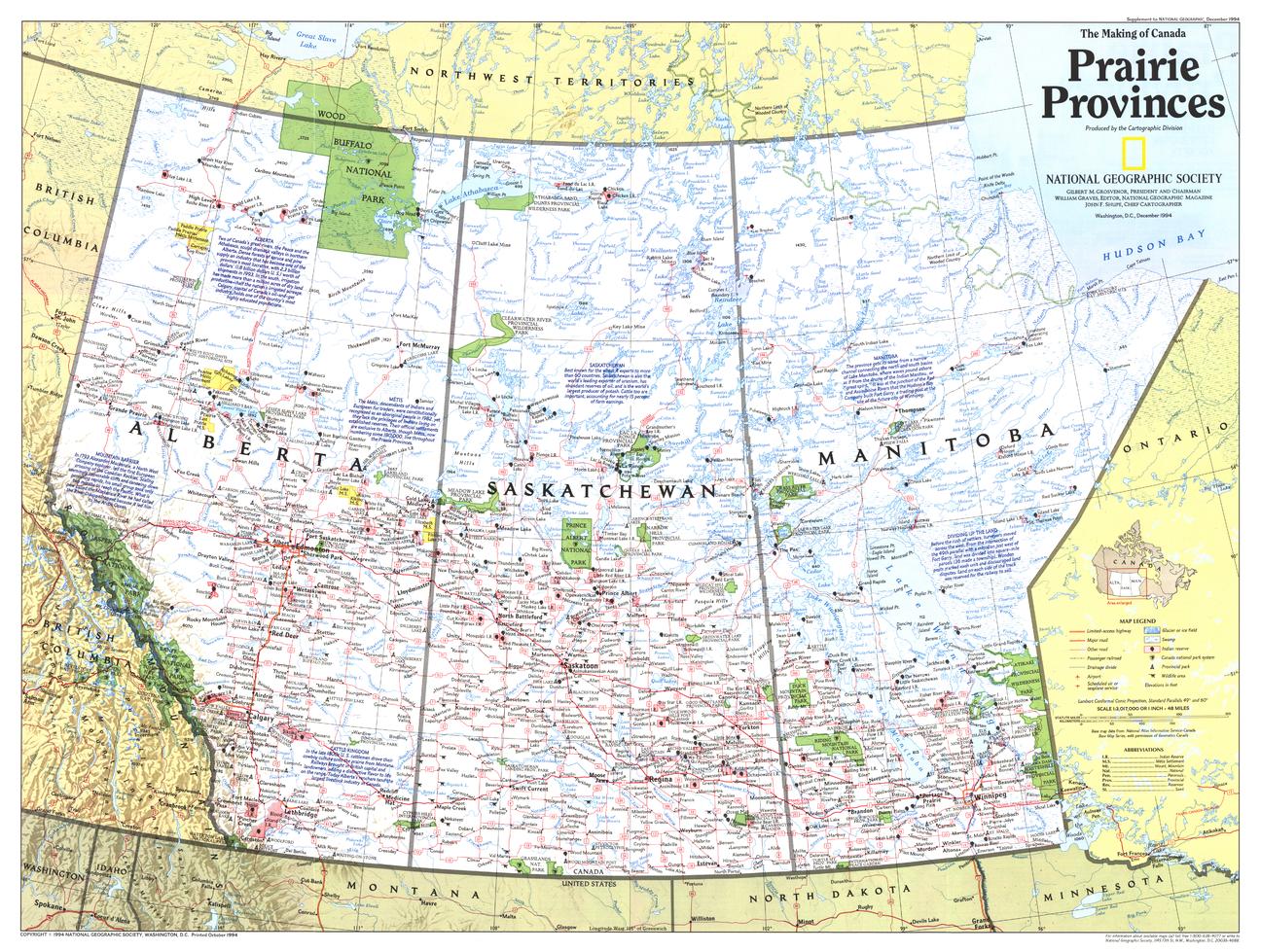
A sweeping view across Canada’s vast interior, Prairie Provinces captures the scale, productivity, and natural character of the nation’s agricultural heartland. Published by National Geographic in December 1994 as part of the Making of Canada series, this map presents a region defined by open landscapes, rich soils, and enduring connections to land and transport.
Covering Alberta, Saskatchewan, and Manitoba, it reveals how geography, agriculture, and infrastructure have shaped the Canadian West.
Why This Map Stands Out
A true heartland perspective
Explores the Prairie Provinces as Canada’s agricultural core.
Part of the Making of Canada series
Combines historical narrative with precise cartography.
Landscape and economy intertwined
Highlights how geography supports farming, transport, and settlement.
Rich regional identity
Captures the openness and scale of the Canadian prairies.
A clean, balanced wall map
Ideal for both learning and display.
🗺️ What the Map Shows
- The Prairie Provinces: Alberta, Saskatchewan, and Manitoba
- Vast grasslands and agricultural regions
- Cities, towns, and transport routes across the plains
- Key infrastructure linking east and west, including major rail corridors
- Natural features such as rivers, lakes, and transitional landscapes
- A regional framework connecting land use, settlement, and economy
📐 Size & Format
686 mm (W) × 518 mm (H)
Landscape orientation
A practical format ideal for:
- Classrooms and geography education
- Home offices and studies
- Libraries and regional displays
- Interiors inspired by open landscapes
✨ Premium Finishes
| Format | Description |
|---|---|
| 📜 Paper (160 gsm) | Heavyweight matte-coated paper—ideal for framing. Preserves clarity and fine detail. |
| 🧼 Laminated (Encapsulated) | Sealed in 2 × 80-micron gloss laminate. Durable, wipe-clean, and suitable for reference use. |
| 🪵 Laminated + Timber Hang Rails | Laminated map mounted with lacquered natural timber rails and hanging cord—ready to display. |
| 🖼️ Canvas (395 gsm HP Professional Matte) | Printed with archival pigment inks. Adds depth and a refined finish. |
| 🪵 Canvas + Timber Hang Rails | Canvas paired with timber rails for a gallery-style presentation. |
🔨 Please allow up to 10 working days for professionally mounted hang-railed finishes.
📊 Specifications
| Feature | Detail |
|---|---|
| Title | Making of Canada: Prairie Provinces |
| Publisher | National Geographic |
| Published | 1994 |
| Scale | 1:3,017,000 |
| Dimensions | 686 mm × 518 mm |
| Orientation | Landscape |
| Map Type | Historical / Regional |
| Coverage | Alberta, Saskatchewan & Manitoba |
| Collections | Canada, Historical |
| Materials | 160 gsm matte paper / 2 × 80-micron laminate / 395 gsm HP Professional Matte Canvas |
| Printing | Pigment-based, fade-resistant inks |
| Origin | Printed in Australia |
🎯 Ideal For
- Students and educators of Canadian geography and agriculture
- Those interested in regional development and transport history
- Collectors of National Geographic historical maps
- Interiors seeking a clean, landscape-focused display piece
- Gift buyers looking for a distinctive Canadian regional map
🌾 Canada’s Open Landscape
The Prairie Provinces are defined by scale and productivity:
- Vast, fertile plains stretching to the horizon
- Agricultural systems feeding a nation
- Railways and infrastructure linking coast to coast
- Landscapes shaped by both nature and human endeavour
This map captures that essence—offering a clear and compelling view of a region where land, industry, and movement come together.
🤝 Our Commitment
- Printed in Australia using archival-quality production
- Faithfully reproduced to preserve clarity and detail
- Premium materials selected for durability and longevity
- Each map is hand-checked before dispatch
- Carefully packaged for safe delivery
🚚 Delivery
- Paper, Laminated, Canvas (rolled): Dispatch within 1–2 business days
- Hang-Railed Maps: Made to order—allow up to 10 working days
- Packaging: Securely rolled in protective tubing
Explore Canada’s agricultural heartland—
a map that brings the Prairie Provinces into wide, open focus.
👉 Order now and add a sweeping Canadian landscape to your wall.
Original: $57.20
-65%$57.20
$20.02Product Information
Product Information
Shipping & Returns
Shipping & Returns
Description
Historical Regional Map | Alberta, Saskatchewan & Manitoba | Wall Format (686 × 518 mm) | Premium Finishes
A sweeping view across Canada’s vast interior, Prairie Provinces captures the scale, productivity, and natural character of the nation’s agricultural heartland. Published by National Geographic in December 1994 as part of the Making of Canada series, this map presents a region defined by open landscapes, rich soils, and enduring connections to land and transport.
Covering Alberta, Saskatchewan, and Manitoba, it reveals how geography, agriculture, and infrastructure have shaped the Canadian West.
Why This Map Stands Out
A true heartland perspective
Explores the Prairie Provinces as Canada’s agricultural core.
Part of the Making of Canada series
Combines historical narrative with precise cartography.
Landscape and economy intertwined
Highlights how geography supports farming, transport, and settlement.
Rich regional identity
Captures the openness and scale of the Canadian prairies.
A clean, balanced wall map
Ideal for both learning and display.
🗺️ What the Map Shows
- The Prairie Provinces: Alberta, Saskatchewan, and Manitoba
- Vast grasslands and agricultural regions
- Cities, towns, and transport routes across the plains
- Key infrastructure linking east and west, including major rail corridors
- Natural features such as rivers, lakes, and transitional landscapes
- A regional framework connecting land use, settlement, and economy
📐 Size & Format
686 mm (W) × 518 mm (H)
Landscape orientation
A practical format ideal for:
- Classrooms and geography education
- Home offices and studies
- Libraries and regional displays
- Interiors inspired by open landscapes
✨ Premium Finishes
| Format | Description |
|---|---|
| 📜 Paper (160 gsm) | Heavyweight matte-coated paper—ideal for framing. Preserves clarity and fine detail. |
| 🧼 Laminated (Encapsulated) | Sealed in 2 × 80-micron gloss laminate. Durable, wipe-clean, and suitable for reference use. |
| 🪵 Laminated + Timber Hang Rails | Laminated map mounted with lacquered natural timber rails and hanging cord—ready to display. |
| 🖼️ Canvas (395 gsm HP Professional Matte) | Printed with archival pigment inks. Adds depth and a refined finish. |
| 🪵 Canvas + Timber Hang Rails | Canvas paired with timber rails for a gallery-style presentation. |
🔨 Please allow up to 10 working days for professionally mounted hang-railed finishes.
📊 Specifications
| Feature | Detail |
|---|---|
| Title | Making of Canada: Prairie Provinces |
| Publisher | National Geographic |
| Published | 1994 |
| Scale | 1:3,017,000 |
| Dimensions | 686 mm × 518 mm |
| Orientation | Landscape |
| Map Type | Historical / Regional |
| Coverage | Alberta, Saskatchewan & Manitoba |
| Collections | Canada, Historical |
| Materials | 160 gsm matte paper / 2 × 80-micron laminate / 395 gsm HP Professional Matte Canvas |
| Printing | Pigment-based, fade-resistant inks |
| Origin | Printed in Australia |
🎯 Ideal For
- Students and educators of Canadian geography and agriculture
- Those interested in regional development and transport history
- Collectors of National Geographic historical maps
- Interiors seeking a clean, landscape-focused display piece
- Gift buyers looking for a distinctive Canadian regional map
🌾 Canada’s Open Landscape
The Prairie Provinces are defined by scale and productivity:
- Vast, fertile plains stretching to the horizon
- Agricultural systems feeding a nation
- Railways and infrastructure linking coast to coast
- Landscapes shaped by both nature and human endeavour
This map captures that essence—offering a clear and compelling view of a region where land, industry, and movement come together.
🤝 Our Commitment
- Printed in Australia using archival-quality production
- Faithfully reproduced to preserve clarity and detail
- Premium materials selected for durability and longevity
- Each map is hand-checked before dispatch
- Carefully packaged for safe delivery
🚚 Delivery
- Paper, Laminated, Canvas (rolled): Dispatch within 1–2 business days
- Hang-Railed Maps: Made to order—allow up to 10 working days
- Packaging: Securely rolled in protective tubing
Explore Canada’s agricultural heartland—
a map that brings the Prairie Provinces into wide, open focus.
👉 Order now and add a sweeping Canadian landscape to your wall.


