Making of Canada, Prairie Provinces Theme - Published 1994 by National Geographic
Historical & Thematic Map | Exploration, Settlement & Modern Prairie Life | Wall Format (686 × 518 mm) | Premium Finishes
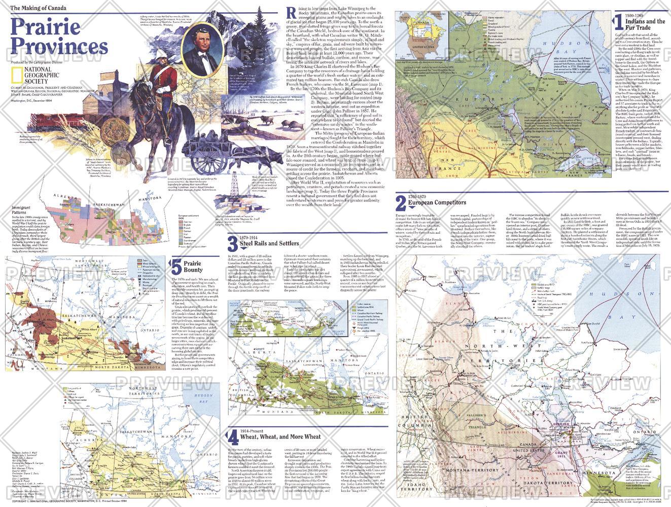
A rich companion to the Prairie Provinces map, this Theme Map (Side Two) traces the evolution of Canada’s vast interior—from early exploration to modern agricultural landscapes. Published by National Geographic in December 1994 as part of the Making of Canada series, it presents a layered narrative of growth across Alberta, Saskatchewan, and Manitoba.
Through a series of thematic maps, it connects the past with the present—showing how exploration, settlement, and infrastructure shaped the Prairie Provinces into Canada’s agricultural heartland.
Why This Map Stands Out
A deeper historical perspective
Expands on the regional map with detailed thematic insights.
Part of a two-map set
Designed as Side Two, complementing the primary Prairie Provinces map.
Multi-period storytelling
Traces exploration, settlement, and modern development.
Balanced and informative
Links early frontier history with contemporary regional life.
A refined wall map
Ideal for pairing or standalone display.
🗺️ What the Map Shows
- A collection of thematic maps detailing:
- Early exploration routes across the plains
- Patterns of settlement and agricultural expansion
- The transformation from frontier landscapes to organised provinces
- Development of towns, transport networks, and farming regions
- Geographic factors influencing growth and land use
- A cohesive view linking history, environment, and present-day prairie life
📐 Size & Format
686 mm (W) × 518 mm (H)
Landscape orientation
A practical format ideal for:
- Classrooms and history education
- Home offices and studies
- Libraries and regional displays
- Pairing with the companion Prairie Provinces map
✨ Premium Finishes
| Format | Description |
|---|---|
| 📜 Paper (160 gsm) | Heavyweight matte-coated paper—ideal for framing. Preserves clarity across thematic panels. |
| 🧼 Laminated (Encapsulated) | Sealed in 2 × 80-micron gloss laminate. Durable, wipe-clean, and suitable for reference use. |
| 🪵 Laminated + Timber Hang Rails | Laminated map mounted with lacquered natural timber rails and hanging cord—ready to display. |
| 🖼️ Canvas (395 gsm HP Professional Matte) | Printed with archival pigment inks. Adds depth and visual richness. |
| 🪵 Canvas + Timber Hang Rails | Canvas paired with timber rails for a refined, gallery-style presentation. |
🔨 Please allow up to 10 working days for professionally mounted hang-railed finishes.
📊 Specifications
| Feature | Detail |
|---|---|
| Title | Making of Canada: Prairie Provinces — Theme Map |
| Publisher | National Geographic |
| Published | 1994 |
| Dimensions | 686 mm × 518 mm |
| Orientation | Landscape |
| Map Type | Historical / Thematic |
| Coverage | Alberta, Saskatchewan & Manitoba |
| Collections | North America, Historical |
| Materials | 160 gsm matte paper / 2 × 80-micron laminate / 395 gsm HP Professional Matte Canvas |
| Printing | Pigment-based, fade-resistant inks |
| Origin | Printed in Australia |
🎯 Ideal For
- Students and educators of Canadian history and regional development
- Those interested in settlement and agricultural expansion
- Collectors of National Geographic historical series maps
- Interiors seeking a clean, heritage-focused display piece
- Gift buyers looking for a meaningful companion map
🌾 From Frontier to Breadbasket
The Prairie Provinces tell a story of transformation:
- Early exploration across vast open landscapes
- Settlement shaped by opportunity and geography
- Expansion of agriculture across fertile plains
- Growth into one of Canada’s most productive regions
This map captures that journey—offering a clear view of how the prairies became a place of scale, productivity, and enduring significance.
🤝 Our Commitment
- Printed in Australia using archival-quality production
- Faithfully reproduced to preserve clarity and historical detail
- Premium materials selected for durability and longevity
- Each map is hand-checked before dispatch
- Carefully packaged for safe delivery
🚚 Delivery
- Paper, Laminated, Canvas (rolled): Dispatch within 1–2 business days
- Hang-Railed Maps: Made to order—allow up to 10 working days
- Packaging: Securely rolled in protective tubing
Complete the Prairie Provinces story—
a map that brings exploration, settlement, and modern life into focus.
👉 Order now and pair it with the companion map for a full regional narrative.
Original: $57.20
-65%$57.20
$20.02Product Information
Product Information
Shipping & Returns
Shipping & Returns
Description
Historical & Thematic Map | Exploration, Settlement & Modern Prairie Life | Wall Format (686 × 518 mm) | Premium Finishes
A rich companion to the Prairie Provinces map, this Theme Map (Side Two) traces the evolution of Canada’s vast interior—from early exploration to modern agricultural landscapes. Published by National Geographic in December 1994 as part of the Making of Canada series, it presents a layered narrative of growth across Alberta, Saskatchewan, and Manitoba.
Through a series of thematic maps, it connects the past with the present—showing how exploration, settlement, and infrastructure shaped the Prairie Provinces into Canada’s agricultural heartland.
Why This Map Stands Out
A deeper historical perspective
Expands on the regional map with detailed thematic insights.
Part of a two-map set
Designed as Side Two, complementing the primary Prairie Provinces map.
Multi-period storytelling
Traces exploration, settlement, and modern development.
Balanced and informative
Links early frontier history with contemporary regional life.
A refined wall map
Ideal for pairing or standalone display.
🗺️ What the Map Shows
- A collection of thematic maps detailing:
- Early exploration routes across the plains
- Patterns of settlement and agricultural expansion
- The transformation from frontier landscapes to organised provinces
- Development of towns, transport networks, and farming regions
- Geographic factors influencing growth and land use
- A cohesive view linking history, environment, and present-day prairie life
📐 Size & Format
686 mm (W) × 518 mm (H)
Landscape orientation
A practical format ideal for:
- Classrooms and history education
- Home offices and studies
- Libraries and regional displays
- Pairing with the companion Prairie Provinces map
✨ Premium Finishes
| Format | Description |
|---|---|
| 📜 Paper (160 gsm) | Heavyweight matte-coated paper—ideal for framing. Preserves clarity across thematic panels. |
| 🧼 Laminated (Encapsulated) | Sealed in 2 × 80-micron gloss laminate. Durable, wipe-clean, and suitable for reference use. |
| 🪵 Laminated + Timber Hang Rails | Laminated map mounted with lacquered natural timber rails and hanging cord—ready to display. |
| 🖼️ Canvas (395 gsm HP Professional Matte) | Printed with archival pigment inks. Adds depth and visual richness. |
| 🪵 Canvas + Timber Hang Rails | Canvas paired with timber rails for a refined, gallery-style presentation. |
🔨 Please allow up to 10 working days for professionally mounted hang-railed finishes.
📊 Specifications
| Feature | Detail |
|---|---|
| Title | Making of Canada: Prairie Provinces — Theme Map |
| Publisher | National Geographic |
| Published | 1994 |
| Dimensions | 686 mm × 518 mm |
| Orientation | Landscape |
| Map Type | Historical / Thematic |
| Coverage | Alberta, Saskatchewan & Manitoba |
| Collections | North America, Historical |
| Materials | 160 gsm matte paper / 2 × 80-micron laminate / 395 gsm HP Professional Matte Canvas |
| Printing | Pigment-based, fade-resistant inks |
| Origin | Printed in Australia |
🎯 Ideal For
- Students and educators of Canadian history and regional development
- Those interested in settlement and agricultural expansion
- Collectors of National Geographic historical series maps
- Interiors seeking a clean, heritage-focused display piece
- Gift buyers looking for a meaningful companion map
🌾 From Frontier to Breadbasket
The Prairie Provinces tell a story of transformation:
- Early exploration across vast open landscapes
- Settlement shaped by opportunity and geography
- Expansion of agriculture across fertile plains
- Growth into one of Canada’s most productive regions
This map captures that journey—offering a clear view of how the prairies became a place of scale, productivity, and enduring significance.
🤝 Our Commitment
- Printed in Australia using archival-quality production
- Faithfully reproduced to preserve clarity and historical detail
- Premium materials selected for durability and longevity
- Each map is hand-checked before dispatch
- Carefully packaged for safe delivery
🚚 Delivery
- Paper, Laminated, Canvas (rolled): Dispatch within 1–2 business days
- Hang-Railed Maps: Made to order—allow up to 10 working days
- Packaging: Securely rolled in protective tubing
Complete the Prairie Provinces story—
a map that brings exploration, settlement, and modern life into focus.
👉 Order now and pair it with the companion map for a full regional narrative.


